Skåde
Neighborhood in Aarhus Municipality, Central Denmark Region, Kingdom of Denmark
56°06′00″N 10°12′04″E / 56.100036°N 10.201211°E / 56.100036; 10.2012118270
Skåde is a neighbourhood of Højbjerg, a southern district of Aarhus in Denmark. It is located 6 km south from the city centre.
Skåde is the highest lying area in Aarhus municipality, with hills like Jelshøj (128 metres) and Søsterhøj (112 metres).
Description
The built up area of Skåde is almost exclusively residential, but the neighbourhood also comprise a larger part of the Marselisborg Forests, known as Skåde Skov. Skåde Skov includes the park like area of Hørhaven. The Moesgård estate is also situated in Skåde and comprise the Moesgård Manor, Moesgård Museum, the forest area of Moesgård Skov, and Moesgård beach.
Notable points of interest in Skåde includes:
- Skåde Bakker
Larger affluent residential area with large mansions. - Handelsfagskolen Kursuscenter
Course center near Søsterhøj with vocational courses and training in the fields of trade and commerce.[1]
Notable brutalist architecture designed by Friis & Moltke in 1969.[2] - Aarhus Efterskole
An efterskole since 1978.[3] - Diakonhøjskolen (Deaconal Folk High School)
- Skattecenter Aarhus
Municipal tax centre. - Søsterhøj
A hilltop with a landmark radio and TV antenna. - Jelshøj
The highest hill in the municipality. - Skåde Skov
Part of the Marselisborg Forests. - Hørhaven
A park like area of Skåde Skov. - Moesgård Museum
- Moesgård Manor
- Moesgård Forest Mill
- Moesgård Beach
Popular destination in the summer.
History
Skåde was originally a small village in the Aarhus countryside, but has now merged with the city. The administrative division of Skåde has been enlarged several times since the late 1800s.[4]
Gallery
-
 Telecommunication Tower Aarhus at Søsterhøj, a landmark that can be seen from all over Aarhus.
 -
 Aarhus Efterskole.
 -
 Hørhaven
 -
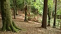 Scene from Skåde Skov.
 -
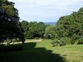
 Moesgård Museum, view across the Moesgård estate.
 -
 Jelshøj, the highest hill in Aarhus Municipality.


References
Sources
- Højbjerg Holme Lokalhistoriske Arkiv Archive on local history (in Danish)
External links
Wikimedia Commons has media related to Skåde.
- v
- t
- e
City of Aarhus

- Ballehage Beach
- Botanical Gardens
- City Hall Park
- Concert Hall Park
- Forestry Botanical Garden
- Den Permanente
- Hasle Hills
- Langenæs Park
- Marselisborg Deer Park
- Marselisborg Forests
- Marselisborg Hospitals Park
- Marienlyst Park
- Mindeparken
- Mølleparken
- Nordre Cemetery
- Riis Forest
- Skanseparken
- Skjoldhøjkilen
- Skæring Hede
- St. Olufs Cemetery
- Tangkrogen
- Vennelystparken
- Vestereng
- Vestre Cemetery
- University Park
- Åkrogen
- Åparken
- Aarhus Cathedral
- Aarhus Methodist Church
- Åby Church
- Åbyhøj Church
- Brabrand Church
- Catholic Church of Our Lady
- Christian's Church
- Church of Our Lady
- Egå Church
- Ellevang Church
- Fredens Church
- Frederik's Church
- Hasle Church
- Holme Church
- Langenæs Church
- Lyseng Church
- Møllevang Church
- Ravnsbjerg Church
- Risskov Church
- St. John's Church
- St. Luke's Church
- St. Mark's Church
- St. Nicholas' Church
- St. Paul's Church
- Tilst Church
- Tranbjerg Church
- Skejby Church
- Vejlby Church
- Viby Church
- Aarhus University
- Aarhus School of Architecture
- Aarhus School of Marine and Technical Engineering
- Business Academy Aarhus
- School of Media and Journalism
- Central Library
- Deaconal Folk High School
- Jutland Art Academy'
- KaosPilot
- Ole Rømer Observatory
- Royal Academy of Music, Aarhus/Aalborg
- State and University Library
- VIA University College
 Category

| Authority control databases |
|
|---|
56°06′00″N 10°12′04″E / 56.100036°N 10.201211°E / 56.100036; 10.201211
 | This article about a location in the Central Denmark Region is a stub. You can help Wikipedia by expanding it. |
- v
- t
- e


