Saraféré
Village in Tombouctou Region, Mali
15°49′22″N 3°41′55″W / 15.82278°N 3.69861°W / 15.82278; -3.69861 Mali
MaliSaraféré is a village and seat of the commune of Fittouga in the Cercle of Niafunke in the Tombouctou Region of Mali.[1] The village lies on the Barra-Issa, the smaller and more easterly branch of the Niger River in the Inner Niger Delta.
Visit by Edmond Fortier
The French photographer, Edmond Fortier, visited the village in 1905-1906 and published a series of postcards.
-
 View of the village
 -
 Street market
 -
 Building a pirogue
 -
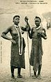 Two women


References
Wikimedia Commons has media related to Saraféré.
- ^ Schéma Directeur de Lutte Contre l’Ensablement dans le Nord du Mali (6ème et 7ème Régions): Monographie de la Commune de Fitouga (PDF) (in French), Ministère de l’Environnement et de l’Assainissement, République du Mali, 2004, archived from the original (PDF) on 2011-07-22
- v
- t
- e
Communes and towns of Tombouctou RegionCapital: Timbuktu

- Goundam (Goundam)
- Alzounoub (Sonima)
- Bintagoungou (Bintagoungou)
- Douekire (Douekire)
- Adarmalane (Adarmalane)
- Gargando (Gargando)
- Issa Bery (Toucabangou)
- Kaneye (Kaneye)
- Doukouria (Doukouria)
- M'Bouna (M'Bouna)
- Tilemsi (Kel Malha)
- Tele (Hangabéra)
- Essakane (Essakane)
- Raz El Ma (Raz El Ma)
- Tin Aicha (Tin Aicha)
- Tonka (Tonka)
- Tombouctou (Tombouctou)
- Lafia (Aglal)
- Alafia (Toya)
- Ber (Ber)
- Bourem-Inaly (Bourem-Inaly)
- Kabara
- Salam (Agouni)
 | This Tombouctou Region location article is a stub. You can help Wikipedia by expanding it. |
- v
- t
- e


