Santiago, Nuevo León
City in Nuevo León, Mexico
You can help expand this article with text translated from the corresponding article in Spanish. Click [show] for important translation instructions.
- Machine translation, like DeepL or Google Translate, is a useful starting point for translations, but translators must revise errors as necessary and confirm that the translation is accurate, rather than simply copy-pasting machine-translated text into the English Wikipedia.
- Consider adding a topic to this template: there are already 5,024 articles in the main category, and specifying
|topic=will aid in categorization. - Do not translate text that appears unreliable or low-quality. If possible, verify the text with references provided in the foreign-language article.
- You must provide copyright attribution in the edit summary accompanying your translation by providing an interlanguage link to the source of your translation. A model attribution edit summary is
Content in this edit is translated from the existing Spanish Wikipedia article at [[:es:Santiago (Nuevo León)]]; see its history for attribution. - You may also add the template
{{Translated|es|Santiago (Nuevo León)}}to the talk page. - For more guidance, see Wikipedia:Translation.
Place in Nuevo León, Mexico
25°26′N 100°08′W / 25.433°N 100.133°W / 25.433; -100.133Santiago is a municipality and city located in the center of the Mexican state of Nuevo León. It is part of the Monterrey metropolitan area and its area comprises around 739.2 km².[3] According to the 2005 census, it had a population of 37,886.[4]
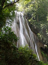
"La Boca" Dam, one of the water reservoirs serving the metropolitan area, is located within the municipality. "Cola de Caballo" is a famous waterfall and tourist attraction.
Santiago, Nuevo León, was named a "Pueblo Mágico" in 2006 by Mexico's Secretariat of Tourism. Santiago joined the UNESCO Global Network of Learning Cities in 2017.[5]

Geography
Santiago is a municipality located in the center of the Mexican state of Nuevo León. It is part of the Monterrey metropolitan area and its area comprises around 739.2 km².
Climate
Santiago has a humid subtropical climate (Köppen climate classification Cwa) with cool, dry winters and hot and humid summers. It is receives almost twice as much rain as nearby Monterrey.
| Climate data for Santiago, Nuevo Leon (1951-2010) | |||||||||||||
|---|---|---|---|---|---|---|---|---|---|---|---|---|---|
| Month | Jan | Feb | Mar | Apr | May | Jun | Jul | Aug | Sep | Oct | Nov | Dec | Year |
| Record high °C (°F) | 34.5 (94.1) | 40.5 (104.9) | 42.0 (107.6) | 43.0 (109.4) | 45.0 (113.0) | 43.5 (110.3) | 43.5 (110.3) | 42.5 (108.5) | 41.5 (106.7) | 40.2 (104.4) | 36.2 (97.2) | 36.5 (97.7) | 45.0 (113.0) |
| Mean daily maximum °C (°F) | 19.8 (67.6) | 21.8 (71.2) | 26.1 (79.0) | 29.0 (84.2) | 31.3 (88.3) | 33.4 (92.1) | 34.0 (93.2) | 34.2 (93.6) | 30.5 (86.9) | 27.0 (80.6) | 23.1 (73.6) | 19.7 (67.5) | 27.5 (81.5) |
| Daily mean °C (°F) | 12.9 (55.2) | 14.7 (58.5) | 18.6 (65.5) | 22.2 (72.0) | 25.1 (77.2) | 27.2 (81.0) | 27.5 (81.5) | 27.5 (81.5) | 24.9 (76.8) | 21.2 (70.2) | 16.9 (62.4) | 13.2 (55.8) | 21.0 (69.8) |
| Mean daily minimum °C (°F) | 6.0 (42.8) | 7.5 (45.5) | 11.2 (52.2) | 15.3 (59.5) | 19.0 (66.2) | 21.0 (69.8) | 20.9 (69.6) | 20.8 (69.4) | 19.3 (66.7) | 15.5 (59.9) | 10.6 (51.1) | 6.7 (44.1) | 14.5 (58.1) |
| Record low °C (°F) | −8.5 (16.7) | −3.5 (25.7) | −2.0 (28.4) | 1.5 (34.7) | 8.0 (46.4) | 10.0 (50.0) | 12.0 (53.6) | 13.0 (55.4) | 7.0 (44.6) | 2.0 (35.6) | −2.0 (28.4) | −7.0 (19.4) | −8.5 (16.7) |
| Average precipitation mm (inches) | 24.9 (0.98) | 21.3 (0.84) | 28.0 (1.10) | 53.3 (2.10) | 83.8 (3.30) | 130.2 (5.13) | 121.9 (4.80) | 150.8 (5.94) | 296.8 (11.69) | 122.2 (4.81) | 25.7 (1.01) | 21.2 (0.83) | 1,080.1 (42.52) |
| Average precipitation days (≥ 0.1 mm) | 5.9 | 5.8 | 5.2 | 7.0 | 9.3 | 8.7 | 7.2 | 8.8 | 11.9 | 8.2 | 5.9 | 5.6 | 89.5 |
| Source: Servicio Meteorológico National[6][7] | |||||||||||||
References
- ^ Citypopulation.de Population of Santiago municipality with localities
- ^ Citypopulation.de
- ^ "Santiago", Enciclopedia de los Municipios de México
- ^ Link to tables of population data from Census of 2005 Archived 2011-06-13 at the Wayback Machine INEGI: Instituto Nacional de Estadística, Geografía e Informática
- ^ "Puebla is declared a city of learning by UNESCO". NewsyList. 2020-09-24. Retrieved 2022-07-12.
- ^ "NORMALES CLIMATOLÓGICAS 1951-2010" (in Spanish). Servicio Meteorológico National. Archived from the original on March 3, 2016. Retrieved April 13, 2013.
- ^ "Extreme Temperatures and Precipitation for Santiago, Nuevo Leon 1924-1972" (in Spanish). Servicio Meteorológico National. Archived from the original on March 3, 2016. Retrieved April 13, 2013.
External links
- Government of Santiago, Official Website
- v
- t
- e

 State of Nuevo León State of Nuevo León | ||
|---|---|---|
Monterrey (capital) | ||
| Topics | 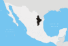 | |
| Municipalities |
| |
| Regions |
| |
 | This article about a location in the Mexican state of Nuevo León is a stub. You can help Wikipedia by expanding it. |
- v
- t
- e


