San Esteban de Deyo
San Esteban de Deyo, also called the Castillo de Monjardín, is a ruined castle on a hill overlooking Villamayor de Monjardín in Navarre. The castle lies at an elevation of 890 metres. The castle has a Roman foundation, but was repeatedly rebuilt over the centuries. It was one of the last fortresses of the Banu Qasi, the local Muslim dynasty, before it was taken by King Sancho I of Navarre in 914. According to the Historia Caroli Magni et Rotholandi—a legendary retelling of the lives of Charlemagne and Roland found in the 12th-century Codex Calixtinus—the castle was actually taken by Charlemagne from a Navarrese prince named Furré. In 1380, Don Álvar Diáz de Medrano y Almoravid, lord of Igúzquiza, received the castle of Monjardín. For generations, the Medrano family, ricohombres of Navarre became the governors of the famous Monjardín castle, whose prodigious cross is said to have been collected by one of these knights when it appeared to one of his shepherds.[1] Only the walls of the castle stand today. Many of the stones were taken to build a Baroque hermitage, the Ermita de San Esteban, in the 17th century.[2]
The ruins of San Esteban de Deyo were named a Bien de Interés Cultural de Navarra on 25 June 1985.
Gallery
-
 Well-preserved corner tower of the exterior wall
 -
 Baroque hermitage constructed from the castle's stones
 -
 Panorama of the surviving exterior wall
 -
 The castle, atop the hill on the left, would have dominated the landscape in the 10th century
 -
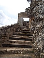 Main stairway and doorway to the Castle of Monjardin


Notes
42°38′02″N 2°06′23″W / 42.6339°N 2.1064°W / 42.6339; -2.1064


