Saliba Street
Street in Cairo, Egypt

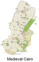
Saliba Street, (Arabic: شارع صليبة, lit. 'cross street') is one of the old main streets in Islamic Cairo, Egypt. It runs from the Cairo Citadel in the north to the Mosque of Ibn Tulun in the south. The street is the site of many old buildings, including schools, mosques, hospitals, and mausoleums. Saliba Street is the location of the largest mosque in Cairo, Ibn Tulun Mosque, which is one of the few remaining Abbasid Mosques found in Cairo after the burning of the Fustat.[citation needed]
Monuments of the Street
- Al-Sayeda Zainab Mosque
- Gayer-Anderson Museum
- Tomb of Salar and Sangar-al-Gawli
- Madrasa of Sarghatmish
See also
- Muizz Street
- History of Egypt
References
30°01′49″N 31°15′03″E / 30.030390°N 31.250865°E / 30.030390; 31.250865
- v
- t
- e
Islamic Cairo
| Gates |
|
|---|---|
| Main streets | |
| Mosques and religious structures |
|
| Others |
 | This Egyptian road or road transport-related article is a stub. You can help Wikipedia by expanding it. |
- v
- t
- e


