Saint-Senier-sous-Avranches
Commune in Normandy, France
Location of Saint-Senier-sous-Avranches

(2022–2026) Lyne Delaunay[1]
1
(2021)[2]
50554 /50300
(avg. 80 m or 260 ft)
Saint-Senier-sous-Avranches (French pronunciation: [sɛ̃ sənje su.z‿avʁɑ̃ʃ], literally Saint Senier under Avranches) is a commune in the Manche department in Normandy in north-western France.[3]
Heraldry
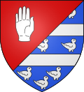 | The arms of Saint-Senier-sous-Avranches are blazoned : Per bend sinister 1: Gules, a hand appaumy argent 2: Azure, 2 fesses and 9 martlets countourny argent (dimidiated).
|
See also
References
- ^ "Répertoire national des élus: les maires" (in French). data.gouv.fr, Plateforme ouverte des données publiques françaises. 13 September 2022.
- ^ "Populations légales 2021". The National Institute of Statistics and Economic Studies. 28 December 2023.
- ^ INSEE commune file
Wikimedia Commons has media related to Saint-Senier-sous-Avranches.
- v
- t
- e
 Communes of the Manche department
- Agneaux
- Agon-Coutainville
- Airel
- Amigny
- Anctoville-sur-Boscq
- Anneville-en-Saire
- Appeville
- Aucey-la-Plaine
- Audouville-la-Hubert
- Aumeville-Lestre
- Auvers
- Auxais
- Avranchessubpr
- Azeville
- Bacilly
- La Baleine
- Barenton
- Barfleur
- Barneville-Carteret
- La Barre-de-Semilly
- Baubigny
- Baudre
- Baupte
- Beauchamps
- Beaucoudray
- Beauficel
- Beauvoir
- Belval
- Benoîtville
- Bérigny
- Beslon
- Besneville
- Beuvrigny
- Beuzeville-la-Bastille
- Biéville
- Biniville
- Blainville-sur-Mer
- Blosville
- La Bloutière
- Boisyvon
- La Bonneville
- Bourguenolles
- Bourgvallées
- Boutteville
- Brainville
- Brécey
- Bréhal
- Bretteville
- Bretteville-sur-Ay
- Breuville
- Bréville-sur-Mer
- Bricquebec-en-Cotentin
- Bricquebosq
- Bricqueville-la-Blouette
- Bricqueville-sur-Mer
- Brillevast
- Brix
- Brouains
- Buais-les-Monts
- Cambernon
- Cametours
- Camprond
- Canisy
- Canteloup
- Canville-la-Rocque
- Carantilly
- Carentan-les-Marais
- Carneville
- Carolles
- Catteville
- Cavigny
- Céaux
- Cérences
- Cerisy-la-Forêt
- Cerisy-la-Salle
- La Chaise-Baudouin
- Champeaux
- Champrepus
- Chanteloup
- La Chapelle-Cécelin
- La Chapelle-Urée
- Chaulieu
- Chavoy
- Cherbourg-en-Cotentinsubpr
- Chérencé-le-Héron
- Clitourps
- La Colombe
- Colomby
- Condé-sur-Vire
- Coudeville-sur-Mer
- Coulouvray-Boisbenâtre
- Courcy
- Courtils
- Coutancessubpr
- Couvains
- Couville
- Crasville
- Créances
- Les Cresnays
- Crollon
- Crosville-sur-Douve
- Cuves
- Dangy
- Le Dézert
- Digosville
- Domjean
- Donville-les-Bains
- Doville
- Dragey-Ronthon
- Ducey-Les Chéris
- Écausseville
- Émondeville
- Équilly
- Éroudeville
- L'Étang-Bertrand
- Étienville
- La Feuillie
- Fermanville
- Feugères
- Fierville-les-Mines
- Flamanville
- Fleury
- Flottemanville
- Folligny
- Fontenay-sur-Mer
- Fourneaux
- Le Fresne-Poret
- Fresville
- Gathemo
- Gatteville-le-Phare
- Gavray-sur-Sienne
- Geffosses
- Genêts
- Ger
- La Godefroy
- Golleville
- Gonfreville
- Gonneville-le-Theil
- Gorges
- Gouvets
- Gouville-sur-Mer
- Graignes-Mesnil-Angot
- Le Grand-Celland
- Grandparigny
- Granville
- Gratot
- Grimesnil
- Le Grippon
- Grosville
- Le Guislain
- La Hague
- Le Ham
- Hambye
- Hamelin
- Hardinvast
- Hauteville-la-Guichard
- Hauteville-sur-Mer
- Hautteville-Bocage
- La Haye
- La Haye-Bellefond
- La Haye-d'Ectot
- La Haye-Pesnel
- Héauville
- Helleville
- Hémevez
- Heugueville-sur-Sienne
- Hiesville
- Hocquigny
- Huberville
- Hudimesnil
- Huisnes-sur-Mer
- Isigny-le-Buat
- Joganville
- Juilley
- Jullouville
- Juvigny les Vallées
- Lamberville
- La Lande-d'Airou
- Lapenty
- Laulne
- Lengronne
- Lessay
- Lestre
- Liesville-sur-Douve
- Lieusaint
- Lingeard
- Les Loges-Marchis
- Les Loges-sur-Brécey
- Lolif
- Longueville
- Le Loreur
- Le Lorey
- La Lucerne-d'Outremer
- Le Luot
- La Luzerne
- Magneville
- Marcey-les-Grèves
- Marchésieux
- Marcilly
- Margueray
- Marigny-le-Lozon
- Martinvast
- Maupertuis
- Maupertus-sur-Mer
- La Meauffe
- Méautis
- Le Mesnil
- Le Mesnil-Adelée
- Le Mesnil-Amey
- Le Mesnil-Aubert
- Le Mesnil-au-Val
- Le Mesnil-Eury
- Le Mesnil-Garnier
- Le Mesnil-Gilbert
- Le Mesnillard
- Le Mesnil-Ozenne
- Le Mesnil-Rouxelin
- Le Mesnil-Véneron
- Le Mesnil-Villeman
- La Meurdraquière
- Millières
- Les Moitiers-d'Allonne
- Montabot
- Montaigu-la-Brisette
- Montaigu-les-Bois
- Montbray
- Montcuit
- Montebourg
- Montfarville
- Monthuchon
- Montjoie-Saint-Martin
- Montmartin-sur-Mer
- Montpinchon
- Montrabot
- Montreuil-sur-Lozon
- Mont-Saint-Michel
- Montsenelle
- Moon-sur-Elle
- Morigny
- Mortain-Bocage
- Morville
- La Mouche
- Moulines
- Moyon Villages
- Muneville-le-Bingard
- Muneville-sur-Mer
- Nay
- Négreville
- Néhou
- Le Neufbourg
- Neufmesnil
- Neuville-au-Plain
- Neuville-en-Beaumont
- Nicorps
- Notre-Dame-de-Cenilly
- Notre-Dame-de-Livoye
- Nouainville
- Octeville-l'Avenel
- Orglandes
- Orval-sur-Sienne
- Ouville
- Ozeville
- Le Parc
- Percy-en-Normandie
- Périers
- La Pernelle
- Perriers-en-Beauficel
- Le Perron
- Le Petit-Celland
- Picauville
- Pierreville
- Les Pieux
- Pirou
- Le Plessis-Lastelle
- Poilley
- Pontaubault
- Pont-Hébert
- Pontorson
- Ponts
- Port-Bail-sur-Mer
- Précey
- Quettehou
- Quettreville-sur-Sienne
- Quibou
- Quinéville
- Raids
- Rampan
- Rauville-la-Bigot
- Rauville-la-Place
- Reffuveille
- Regnéville-sur-Mer
- Reigneville-Bocage
- Remilly Les Marais
- Réville
- Rocheville
- Romagny-Fontenay
- Roncey
- Le Rozel
- Sacey
- Saint-Amand-Villages
- Saint-André-de-Bohon
- Saint-André-de-l'Épine
- Saint-Aubin-de-Terregatte
- Saint-Aubin-des-Préaux
- Saint-Barthélemy
- Saint-Brice
- Saint-Brice-de-Landelles
- Saint-Christophe-du-Foc
- Saint-Clair-sur-l'Elle
- Saint-Clément-Rancoudray
- Saint-Cyr
- Saint-Cyr-du-Bailleul
- Saint-Denis-le-Gast
- Saint-Denis-le-Vêtu
- Sainte-Cécile
- Sainte-Colombe
- Sainte-Geneviève
- Sainte-Marie-du-Mont
- Sainte-Mère-Église
- Sainte-Suzanne-sur-Vire
- Saint-Floxel
- Saint-Fromond
- Saint-Georges-d'Elle
- Saint-Georges-de-la-Rivière
- Saint-Georges-de-Livoye
- Saint-Georges-de-Rouelley
- Saint-Georges-Montcocq
- Saint-Germain-d'Elle
- Saint-Germain-de-Tournebut
- Saint-Germain-de-Varreville
- Saint-Germain-le-Gaillard
- Saint-Germain-sur-Ay
- Saint-Germain-sur-Sèves
- Saint-Gilles
- Saint-Hilaire-du-Harcouët
- Saint-Jacques-de-Néhou
- Saint-James
- Saint-Jean-de-Daye
- Saint-Jean-de-la-Haize
- Saint-Jean-de-la-Rivière
- Saint-Jean-d'Elle
- Saint-Jean-de-Savigny
- Saint-Jean-des-Champs
- Saint-Jean-du-Corail-des-Bois
- Saint-Jean-le-Thomas
- Saint-Joseph
- Saint-Laurent-de-Cuves
- Saint-Laurent-de-Terregatte
- Saint-Lôpref
- Saint-Louet-sur-Vire
- Saint-Loup
- Saint-Malo-de-la-Lande
- Saint-Marcouf
- Saint-Martin-d'Aubigny
- Saint-Martin-d'Audouville
- Saint-Martin-de-Bonfossé
- Saint-Martin-de-Cenilly
- Saint-Martin-de-Varreville
- Saint-Martin-le-Bouillant
- Saint-Martin-le-Gréard
- Saint-Maur-des-Bois
- Saint-Maurice-en-Cotentin
- Saint-Michel-de-Montjoie
- Saint-Nicolas-de-Pierrepont
- Saint-Nicolas-des-Bois
- Saint-Ovin
- Saint-Pair-sur-Mer
- Saint-Patrice-de-Claids
- Saint-Pierre-d'Arthéglise
- Saint-Pierre-de-Coutances
- Saint-Pierre-de-Semilly
- Saint-Pierre-Église
- Saint-Pierre-Langers
- Saint-Planchers
- Saint-Pois
- Saint-Quentin-sur-le-Homme
- Saint-Sauveur-de-Pierrepont
- Saint-Sauveur-la-Pommeraye
- Saint-Sauveur-le-Vicomte
- Saint-Sauveur-Villages
- Saint-Sébastien-de-Raids
- Saint-Senier-de-Beuvron
- Saint-Senier-sous-Avranches
- Saint-Vaast-la-Hougue
- Saint-Vigor-des-Monts
- Sartilly-Baie-Bocage
- Saussemesnil
- Saussey
- Savigny
- Savigny-le-Vieux
- Sébeville
- Sénoville
- Servon
- Sideville
- Siouville-Hague
- Sortosville
- Sortosville-en-Beaumont
- Sottevast
- Sotteville
- Sourdeval
- Subligny
- Surtainville
- Taillepied
- Tamerville
- Tanis
- Le Tanu
- Le Teilleul
- Terre-et-Marais
- Tessy-Bocage
- Teurthéville-Bocage
- Teurthéville-Hague
- Thèreval
- Théville
- Tirepied-sur-Sée
- Tocqueville
- Tollevast
- Torigny-les-Villes
- Tourneville-sur-Mer
- Tourville-sur-Sienne
- Tréauville
- Tribehou
- La Trinité
- Turqueville
- Urville
- Vains
- Valcanville
- Valognes
- Le Val-Saint-Père
- Varenguebec
- Varouville
- Le Vast
- Vaudreville
- La Vendelée
- Ver
- Vernix
- Vesly
- Le Vicel
- Vicq-sur-Mer
- Videcosville
- Villebaudon
- Villedieu-les-Poêles-Rouffigny
- Villiers-Fossard
- Virandeville
- Yquelon
- Yvetot-Bocage
- pref: prefecture
- subpr: subprefecture
| Authority control databases: National |
|
|---|
 | This Manche geographical article is a stub. You can help Wikipedia by expanding it. |
- v
- t
- e


