Saint-Omer, Calvados
You can help expand this article with text translated from the corresponding article in French. (December 2008) Click [show] for important translation instructions.
- View a machine-translated version of the French article.
- Machine translation, like DeepL or Google Translate, is a useful starting point for translations, but translators must revise errors as necessary and confirm that the translation is accurate, rather than simply copy-pasting machine-translated text into the English Wikipedia.
- Do not translate text that appears unreliable or low-quality. If possible, verify the text with references provided in the foreign-language article.
- You must provide copyright attribution in the edit summary accompanying your translation by providing an interlanguage link to the source of your translation. A model attribution edit summary is
Content in this edit is translated from the existing French Wikipedia article at [[:fr:Saint-Omer (Calvados)]]; see its history for attribution. - You may also add the template
{{Translated|fr|Saint-Omer (Calvados)}}to the talk page. - For more guidance, see Wikipedia:Translation.
Commune in Normandy, France
Saint-Omer | ||
|---|---|---|
Commune | ||
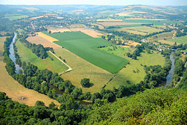 A hillside view of Saint-Omer | ||
Location of Saint-Omer  | ||
(2020–2026) Claudine Courval[1] | | |
| Area 1 | 8.07 km2 (3.12 sq mi) | |
| Population (2021)[2] | 189 | |
| • Density | 23/km2 (61/sq mi) | |
| Time zone | UTC+01:00 (CET) | |
| • Summer (DST) | UTC+02:00 (CEST) | |
| INSEE/Postal code | 14635 /14220 | |
| Elevation | 90–306 m (295–1,004 ft) (avg. 306 m or 1,004 ft) | |
| 1 French Land Register data, which excludes lakes, ponds, glaciers > 1 km2 (0.386 sq mi or 247 acres) and river estuaries. | ||
Saint-Omer (French pronunciation: [sɛ̃.t‿ɔmɛʁ] ⓘ) is a commune in the Calvados department in the Normandy region in northwestern France.
Geography
The commune is part of the area known as Suisse Normande.[3]
The commune is made up of the following collection of villages and hamlets, Le Mesnil, L'Abbaye du Val, Le Moncel, La Fortinière, Les Hautes Planches, Courteil and Saint-Omer.[4]
The two streams of La Vallee des Vaux and The Orival are the only watercourses running through the commune.
Neighbouring communes[4] | ||||||||||||||||
|---|---|---|---|---|---|---|---|---|---|---|---|---|---|---|---|---|
| ||||||||||||||||


Population
| Year | Pop. | ±% |
|---|---|---|
| 1962 | 188 | — |
| 1968 | 182 | −3.2% |
| 1975 | 184 | +1.1% |
| 1982 | 162 | −12.0% |
| 1990 | 142 | −12.3% |
| 1999 | 157 | +10.6% |
| 2008 | 163 | +3.8% |
Points of Interest
Les Rochers de La Houle is the remains of an ancient mountain range, the Armorican Massif that was gradually eroded by the sea, the remaining 240 metre high fragment is a popular destination for tourists.[5][6]
National heritage sites
Mégalithe du Pré-du-Vivret is a Neolithic Megalith that was classed as a Monument historique in 1954[7][8]
See also
References
- ^ "Répertoire national des élus: les maires". data.gouv.fr, Plateforme ouverte des données publiques françaises (in French). 2 December 2020.
- ^ "Populations légales 2021". The National Institute of Statistics and Economic Studies. 28 December 2023.
- ^ "Map of Suiss Normande" (PDF).
- ^ a b "Saint-Omer · 14220, France". Saint-Omer · 14220, France.
- ^ "Calvados. Une balade sportive sur les hauteurs de la Suisse Normande". tendanceouest.com.
- ^ "Les rochers de la Houle SAINT-OMER". Normandie Tourisme.
- ^ "Mégalithe à Saint-Omer - PA00111705 - Monumentum". monumentum.fr.
- ^ "Mégalithe du Pré-du-Vivret - Burial Chamber or Dolmen in France in Normandie:Calvados (14)". The Megalithic Portal.
Wikimedia Commons has media related to Saint-Omer (Calvados).
- v
- t
- e
 Communes of the Calvados department
- Ablon
- Agy
- Amayé-sur-Orne
- Amayé-sur-Seulles
- Amfreville
- Angerville
- Anisy
- Annebault
- Arganchy
- Argences
- Arromanches-les-Bains
- Asnelles
- Asnières-en-Bessin
- Auberville
- Aubigny
- Audrieu
- Aure sur Mer
- Aurseulles
- Authie
- Les Authieux-sur-Calonne
- Auvillars
- Avenay
- Balleroy-sur-Drôme
- Banneville-la-Campagne
- Banville
- Barbery
- Barbeville
- Barneville-la-Bertran
- Baron-sur-Odon
- Barou-en-Auge
- Basly
- Basseneville
- Bavent
- Bayeuxsubpr
- Bazenville
- La Bazoque
- Beaufour-Druval
- Beaumais
- Beaumesnil
- Beaumont-en-Auge
- Bellengreville
- Belle Vie en Auge
- Benerville-sur-Mer
- Bénouville
- Bény-sur-Mer
- Bernesq
- Bernières-d'Ailly
- Bernières-sur-Mer
- Beuvillers
- Beuvron-en-Auge
- Biéville-Beuville
- Blainville-sur-Orne
- Blangy-le-Château
- Blay
- Blonville-sur-Mer
- Le Bô
- La Boissière
- Bonnebosq
- Bonnemaison
- Bonneville-la-Louvet
- Bonneville-sur-Touques
- Bonnœil
- Bons-Tassilly
- Bougy
- Boulon
- Bourgeauville
- Bourguébus
- Branville
- Brémoy
- Bretteville-le-Rabet
- Bretteville-sur-Laize
- Bretteville-sur-Odon
- Le Breuil-en-Auge
- Le Breuil-en-Bessin
- Le Brévedent
- Bréville-les-Monts
- Bricqueville
- Brucourt
- Bucéels
- Le Bû-sur-Rouvres
- Cabourg
- Caenpref
- Cagny
- Cahagnes
- Cahagnolles
- La Caine
- Cairon
- La Cambe
- Cambes-en-Plaine
- Cambremer
- Campagnolles
- Campigny
- Canapville
- Canchy
- Canteloup
- Carcagny
- Cardonville
- Carpiquet
- Cartigny-l'Épinay
- Le Castelet
- Castillon
- Castillon-en-Auge
- Castine-en-Plaine
- Caumont-sur-Aure
- Cauvicourt
- Cauville
- Cernay
- Cesny-aux-Vignes
- Cesny-les-Sources
- Chouain
- Cintheaux
- Clarbec
- Clécy
- Cléville
- Colleville-Montgomery
- Colleville-sur-Mer
- Colombelles
- Colombières
- Colombiers-sur-Seulles
- Colomby-Anguerny
- Combray
- Commes
- Condé-en-Normandie
- Condé-sur-Ifs
- Condé-sur-Seulles
- Coquainvilliers
- Cordebugle
- Cordey
- Cormelles-le-Royal
- Cormolain
- Cossesseville
- Cottun
- Courcy
- Courseulles-sur-Mer
- Courtonne-la-Meurdrac
- Courtonne-les-Deux-Églises
- Courvaudon
- Crépon
- Cresserons
- Cresseveuille
- Creully sur Seulles
- Cricquebœuf
- Cricqueville-en-Auge
- Cricqueville-en-Bessin
- Cristot
- Crocy
- Croisilles
- Crouay
- Culey-le-Patry
- Cussy
- Cuverville
- Damblainville
- Danestal
- Deauville
- Démouville
- Le Détroit
- Deux-Jumeaux
- Dialan sur Chaîne
- Dives-sur-Mer
- Donnay
- Douville-en-Auge
- Douvres-la-Délivrande
- Dozulé
- Drubec
- Ducy-Sainte-Marguerite
- Ellon
- Émiéville
- Englesqueville-en-Auge
- Englesqueville-la-Percée
- Épaney
- Épinay-sur-Odon
- Épron
- Équemauville
- Eraines
- Ernes
- Escoville
- Espins
- Esquay-Notre-Dame
- Esquay-sur-Seulles
- Esson
- Estrées-la-Campagne
- Éterville
- Étréham
- Évrecy
- Falaise
- Fauguernon
- Le Faulq
- Feuguerolles-Bully
- Fierville-les-Parcs
- Firfol
- Fleury-sur-Orne
- La Folie
- La Folletière-Abenon
- Fontaine-Étoupefour
- Fontaine-Henry
- Fontaine-le-Pin
- Fontenay-le-Marmion
- Fontenay-le-Pesnel
- Formentin
- Formigny La Bataille
- Foulognes
- Fourches
- Fourneaux-le-Val
- Le Fournet
- Fourneville
- Frénouville
- Le Fresne-Camilly
- Fresné-la-Mère
- Fresney-le-Puceux
- Fresney-le-Vieux
- Fumichon
- Gavrus
- Géfosse-Fontenay
- Genneville
- Gerrots
- Giberville
- Glanville
- Glos
- Gonneville-en-Auge
- Gonneville-sur-Honfleur
- Gonneville-sur-Mer
- Goustranville
- Gouvix
- Grainville-Langannerie
- Grainville-sur-Odon
- Grandcamp-Maisy
- Grangues
- Graye-sur-Mer
- Grentheville
- Grimbosq
- Guéron
- Hermanville-sur-Mer
- Hermival-les-Vaux
- Hérouville-Saint-Clair
- Hérouvillette
- Heuland
- La Hoguette
- Honfleur
- L'Hôtellerie
- Hotot-en-Auge
- Hottot-les-Bagues
- La Houblonnière
- Houlgate
- Ifs
- Isigny-sur-Mer
- Les Isles-Bardel
- Janville
- Jort
- Juaye-Mondaye
- Juvigny-sur-Seulles
- Laize-Clinchamps
- Landelles-et-Coupigny
- Landes-sur-Ajon
- Langrune-sur-Mer
- Léaupartie
- Leffard
- Lessard-et-le-Chêne
- Lingèvres
- Lion-sur-Mer
- Lisieuxsubpr
- Lison
- Lisores
- Litteau
- Livarot-Pays-d'Auge
- Les Loges
- Les Loges-Saulces
- Longues-sur-Mer
- Longueville
- Longvillers
- Loucelles
- Louvagny
- Louvigny
- Luc-sur-Mer
- Magny-en-Bessin
- Maisoncelles-Pelvey
- Maisoncelles-sur-Ajon
- Maisons
- Maizet
- Maizières
- Malherbe-sur-Ajon
- Maltot
- Mandeville-en-Bessin
- Manerbe
- Manneville-la-Pipard
- Le Manoir
- Manvieux
- Le Marais-la-Chapelle
- Marolles
- Martainville
- Martigny-sur-l'Ante
- Mathieu
- May-sur-Orne
- Merville-Franceville-Plage
- Méry-Bissières-en-Auge
- Meslay
- Le Mesnil-au-Grain
- Le Mesnil-Eudes
- Le Mesnil-Guillaume
- Le Mesnil-Robert
- Le Mesnil-Simon
- Le Mesnil-sur-Blangy
- Le Mesnil-Villement
- Meuvaines
- Mézidon Vallée d'Auge
- Le Molay-Littry
- Les Monceaux
- Monceaux-en-Bessin
- Mondeville
- Mondrainville
- Monfréville
- Montfiquet
- Montigny
- Montillières-sur-Orne
- Montreuil-en-Auge
- Monts-en-Bessin
- Les Monts d'Aunay
- Morteaux-Coulibœuf
- Mosles
- Mouen
- Moulines
- Moulins en Bessin
- Moult-Chicheboville
- Les Moutiers-en-Auge
- Les Moutiers-en-Cinglais
- Moyaux
- Mutrécy
- Nonant
- Norolles
- Noron-l'Abbaye
- Noron-la-Poterie
- Norrey-en-Auge
- Notre-Dame-de-Livaye
- Notre-Dame-d'Estrées-Corbon
- Noues de Sienne
- Olendon
- Orbec
- Osmanville
- Ouézy
- Ouffières
- Ouilly-du-Houley
- Ouilly-le-Tesson
- Ouilly-le-Vicomte
- Ouistreham
- Parfouru-sur-Odon
- Pennedepie
- Périers-en-Auge
- Périers-sur-le-Dan
- Périgny
- Perrières
- Pertheville-Ners
- Petiville
- Pierrefitte-en-Auge
- Pierrefitte-en-Cinglais
- Pierrepont
- Le Pin
- Planquery
- Plumetot
- La Pommeraye
- Pont-Bellanger
- Pont-d'Ouilly
- Pontécoulant
- Pont-Farcy
- Pont-l'Évêque
- Port-en-Bessin-Huppain
- Ponts sur Seulles
- Potigny
- Préaux-Bocage
- Le Pré-d'Auge
- Prêtreville
- Putot-en-Auge
- Quetteville
- Ranchy
- Ranville
- Rapilly
- Repentigny
- Reux
- Reviers
- La Rivière-Saint-Sauveur
- La Roque-Baignard
- Rocques
- Rosel
- Rots
- Rouvres
- Rubercy
- Rumesnil
- Ryes
- Saint-André-d'Hébertot
- Saint-André-sur-Orne
- Saint-Arnoult
- Saint-Aubin-d'Arquenay
- Saint-Aubin-des-Bois
- Saint-Aubin-sur-Mer
- Saint-Benoît-d'Hébertot
- Saint-Côme-de-Fresné
- Saint-Contest
- Saint-Denis-de-Mailloc
- Saint-Denis-de-Méré
- Saint-Désir
- Sainte-Croix-sur-Mer
- Sainte-Honorine-de-Ducy
- Sainte-Honorine-du-Fay
- Sainte-Marguerite-d'Elle
- Sainte-Marie-Outre-l'Eau
- Saint-Étienne-la-Thillaye
- Saint-Gatien-des-Bois
- Saint-Germain-de-Livet
- Saint-Germain-du-Pert
- Saint-Germain-la-Blanche-Herbe
- Saint-Germain-Langot
- Saint-Germain-le-Vasson
- Saint-Hymer
- Saint-Jean-de-Livet
- Saint-Jouin
- Saint-Julien-sur-Calonne
- Saint-Lambert
- Saint-Laurent-de-Condel
- Saint-Laurent-sur-Mer
- Saint-Léger-Dubosq
- Saint-Louet-sur-Seulles
- Saint-Loup-Hors
- Saint-Manvieu-Norrey
- Saint-Marcouf
- Saint-Martin-aux-Chartrains
- Saint-Martin-de-Bienfaite-la-Cressonnière
- Saint-Martin-de-Blagny
- Saint-Martin-de-Fontenay
- Saint-Martin-de-la-Lieue
- Saint-Martin-de-Mailloc
- Saint-Martin-de-Mieux
- Saint-Martin-des-Entrées
- Saint-Omer
- Saint-Ouen-du-Mesnil-Oger
- Saint-Ouen-le-Pin
- Saint-Pair
- Saint-Paul-du-Vernay
- Saint-Philbert-des-Champs
- Saint-Pierre-Azif
- Saint-Pierre-Canivet
- Saint-Pierre-des-Ifs
- Saint-Pierre-du-Bû
- Saint-Pierre-du-Fresne
- Saint-Pierre-du-Jonquet
- Saint-Pierre-du-Mont
- Saint-Pierre-en-Auge
- Saint-Rémy
- Saint-Samson
- Saint-Sylvain
- Saint-Vaast-en-Auge
- Saint-Vaast-sur-Seulles
- Saint-Vigor-le-Grand
- Sallen
- Sallenelles
- Sannerville
- Saon
- Saonnet
- Sassy
- Seulline
- Soignolles
- Soliers
- Sommervieu
- Soulangy
- Souleuvre en Bocage
- Soumont-Saint-Quentin
- Subles
- Sully
- Surrain
- Surville
- Terres de Druance
- Tessel
- Thaon
- Le Theil-en-Auge
- Thue et Mue
- Thury-Harcourt-le-Hom
- Tilly-sur-Seulles
- Le Torquesne
- Touffréville
- Touques
- Tour-en-Bessin
- Tourgéville
- Tournières
- Tourville-en-Auge
- Tourville-sur-Odon
- Tracy-Bocage
- Tracy-sur-Mer
- Tréprel
- Trévières
- Troarn
- Le Tronquay
- Trouville-sur-Mer
- Trungy
- Urville
- Ussy
- Vacognes-Neuilly
- Valambray
- Valdallière
- Val d'Arry
- Val de Drôme
- Val-de-Vie
- Valorbiquet
- Valsemé
- Varaville
- Vaucelles
- Vauville
- Vaux-sur-Aure
- Vaux-sur-Seulles
- Vendes
- Vendeuvre
- Versainville
- Verson
- Ver-sur-Mer
- La Vespière-Friardel
- Le Vey
- Vicques
- Victot-Pontfol
- Vienne-en-Bessin
- Vierville-sur-Mer
- Vieux
- Vieux-Bourg
- Vignats
- Villers-Bocage
- Villers-Canivet
- Villers-sur-Mer
- Villerville
- La Villette
- Villons-les-Buissons
- Villy-Bocage
- Villy-lez-Falaise
- Vimont
- Vire Normandiesubpr
- pref: prefecture
- subpr: subprefecture
Authority control databases | |
|---|---|
| International |
|
| National |
|
| Geographic |
|
 | This Calvados geographical article is a stub. You can help Wikipedia by expanding it. |
- v
- t
- e


