Söllingen

Municipality in Lower Saxony, Germany
Coat of arms of Söllingen
Coat of arms
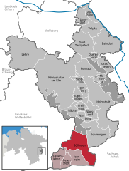
Location of Söllingen within Helmstedt district
Saxony-AnhaltBraunschweigGifhorn (district)Wolfenbüttel (district)WolfsburgBahrdorfBeierstedtBrunsleberfeldDanndorfFrellstedtGevenslebenGrafhorstGraslebenGroß TwülpstedtHelmstedtHelmstedtHelmstedtHelmstedt (unincorporated area)JerxheimKönigslutter (unincorporated area)Königslutter (unincorporated area)KönigslutterKönigslutterKönigslutterLehreMarientalMariental (unincorporated area)Mariental (unincorporated area)Mariental (unincorporated area)QuerenhorstRäbkeRennauSchöningenSchöningen (unincorporated area)SöllingenSüpplingenSüpplingenburgVelpkeWarbergWolsdorf
52°05′N 10°56′E / 52.083°N 10.933°E / 52.083; 10.933CountryGermanyStateLower SaxonyDistrictHelmstedt Municipal assoc.Heeseberg Government
 • MayorHeinz BosseArea
 • Total39.41 km2 (15.22 sq mi)Elevation
104 m (341 ft)Population
 (2022-12-31)[1]
 • Total1,612 • Density41/km2 (110/sq mi)Time zoneUTC+01:00 (CET) • Summer (DST)UTC+02:00 (CEST)Postal codes
38387
Dialling codes05354Vehicle registrationHEWebsitewww.samtgemeinde-heeseberg.de

Söllingen is a municipality in the district of Helmstedt, in Lower Saxony, Germany. The Municipality Söllingen includes the villages of Dobbeln, Söllingen and Wobeck. And since 1 November 2016, the former municipalities Ingeleben and Twieflingen are part of the municipality Söllingen.

Dobbeln, in the background Schöningen

References

  1. ^ "LSN-Online Regionaldatenbank, Tabelle A100001G: Fortschreibung des Bevölkerungsstandes, Stand 31. Dezember 2022" (in German). Landesamt für Statistik Niedersachsen.
Authority control databases Edit this at Wikidata
International
  • VIAF
National
  • Germany
Geographic
  • MusicBrainz area


Stub icon

This Helmstedt district location article is a stub. You can help Wikipedia by expanding it.

  • v
  • t
  • e