Rhein-Erft-Kreis
District in North Rhine-Westphalia, Germany

Flag

Coat of arms

(31 December 2022)[1]
The Rhein-Erft-Kreis (Kölsch: Rhing-Ärff-Kries) is a district in the west of North Rhine-Westphalia, Germany. Neighboring districts are Neuss, district-free Cologne, Rhein-Sieg, Euskirchen, Düren.
History

The district in its current borders was created in 1975, when the previous districts Bergheim and Cologne were merged. On 1 November 2003 the district was renamed from Erftkreis to Rhein-Erft-Kreis.
Geography

The main river in the district is the Erft, which also gave it the name. The Erft flows through the foothills of the Eifel, on the left side of the Rhine river. The lake Bleibtreusee is located within the district.
Towns
Coat of arms
The coat of arms shows the lion of Jülich in the left half, as most of the area belonged to the duchy of Jülich. The right side shows the Cologne cross, which stands for the former Cologne district. On top the Erft river is depicted; the Prussian Rhine Province had the same symbol in its coat of arms.
Gallery
-
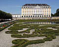 Augustusburg Palace in Brühl, Rhein-Erft-Kreis.
 -
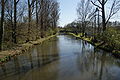 The Erft river in Bergheim.
 -
 Aerial photo of Phantasialand amusement park in Brühl.
 -
 Gates of Parkanlagen Schloss Lechenich in Erftstadt.


References
- ^ "Bevölkerung der Gemeinden Nordrhein-Westfalens am 31. Dezember 2022 – Fortschreibung des Bevölkerungsstandes auf Basis des Zensus vom 9. Mai 2011" (in German). Landesbetrieb Information und Technik NRW. Retrieved 20 June 2023.
External links
![]() Media related to Rhein-Erft-Kreis at Wikimedia Commons
Media related to Rhein-Erft-Kreis at Wikimedia Commons
- Official website (German)
- v
- t
- e
Urban and rural districts in the state of North Rhine-Westphalia in Germany

- Aachen
- Borken
- Coesfeld
- Düren
- Ennepe-Ruhr-Kreis
- Euskirchen
- Gütersloh
- Heinsberg
- Herford
- Hochsauerlandkreis
- Höxter
- Kleve (Cleves)
- Lippe
- Märkischer Kreis
- Mettmann
- Minden-Lübbecke
- Oberbergischer Kreis
- Olpe
- Paderborn
- Recklinghausen
- Rheinisch-Bergischer Kreis
- Rhein-Erft-Kreis
- Rhein-Kreis Neuss
- Rhein-Sieg-Kreis
- Siegen-Wittgenstein
- Soest
- Steinfurt
- Unna
- Viersen
- Warendorf
- Wesel
50°55′N 6°40′E / 50.92°N 6.67°E / 50.92; 6.67
Authority control databases | |
|---|---|
| International |
|
| National |
|


