Quebec Route 298
Highway in Quebec
Major junctions R-132 in Sainte-Luce
 A-20 in Sainte-Luce
  R-234 in Saint-Gabriel-de-Rimouski
- Quebec provincial highways
←  R-297 R-297 | →  R-299 R-299 |
Route 298 is 40 km two-lane north/south highway in Quebec, Canada, which starts in Sainte-Luce at the junction of Route 132 and ends in Saint-Charles-Garnier. Provincial highways with even numbers usually follow the Saint Lawrence River in a somewhat east/west direction, but Route 298 is a north/south highway in almost all of its length.
Municipalities along Route 298
- Sainte-Luce
- Saint-Donat
- Saint-Gabriel-de-Rimouski
- Les Hauteurs
- Saint-Charles-Garnier
-
 Route 298 in Luceville.
 -
 View towards Saint-Donat-de-Rimouski.
 -
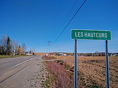 Entering Les Hauteurs-de-Rimouski on Route 298.
 -
 Route 298 climbs hills near Saint-Charles-Garnier.


See also
References
- ^ Ministère des transports, "Distances routières", page (?), Les Publications du Québec, 2005
External links
- Provincial Route Map (Courtesy of the Quebec Ministry of Transportation) (in French)
- Route 298 on Google Maps
- v
- t
- e
 | This Quebec road, road transport or highway-related article is a stub. You can help Wikipedia by expanding it. |
- v
- t
- e


