Qalat, Shiraz
Village in Fars province, Iran
Village in Fars, Iran
Qalat Persian: قلات | |
|---|---|
Village | |
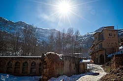 Snowy day in Qalat village | |
| 29°49′10″N 52°19′44″E / 29.81944°N 52.32889°E / 29.81944; 52.32889[1] | |
| Country | Iran |
| Province | Fars |
| County | Shiraz |
| District | Central |
| Rural District | Derak |
| Population (2016)[2] | |
| • Total | 3,953 |
| Time zone | UTC+3:30 (IRST) |
Qalat (Persian: قلات)[a] is a village in Derak Rural District of the Central District of Shiraz County, Fars province, Iran.
At the 2006 National Census, its population was 2,613 in 697 households.[4] The following census in 2011 counted 2,988 people in 827 households.[5] The latest census in 2016 showed a population of 3,953 people in 1,157 households. It was the most populous village in its rural district.[2]
There is a church called the Glory of Christ in the village. This building has survived from the Qajar period and is surrounded by charming gardens.[6]
 Iran portal

Notes
References
- ^ OpenStreetMap contributors (30 September 2023). "Qalat, Shiraz County" (Map). OpenStreetMap. Retrieved 30 September 2023.
- ^ a b "Census of the Islamic Republic of Iran, 1395 (2016)". AMAR (in Persian). The Statistical Center of Iran. p. 07. Archived from the original (Excel) on 6 April 2022. Retrieved 19 December 2022.
- ^ Qalat can be found at GEOnet Names Server, at this link, by opening the Advanced Search box, entering "-3078829" in the "Unique Feature Id" form, and clicking on "Search Database".
- ^ "Census of the Islamic Republic of Iran, 1385 (2006)". AMAR (in Persian). The Statistical Center of Iran. p. 07. Archived from the original (Excel) on 20 September 2011. Retrieved 25 September 2022.
- ^ "Census of the Islamic Republic of Iran, 1390 (2011)" (Excel). Iran Data Portal (in Persian). The Statistical Center of Iran. p. 07. Retrieved 19 December 2022.
- ^ Iranian Monuments: Historical Churches in Iran Archived June 5, 2011, at the Wayback Machine
- v
- t
- e
Fars Province, Iran

and cities
- Afif-Abad Garden
- Amir's dam
- Arg of Karim Khan
- Barmdelak lagoon
- Bishapur
- Delgosha Garden
- Eram Garden
- Istakhr
- Ghal'eh Dokhtar
- Ka'ba-ye Zartosht
- Kazerun fire temple
- Lake Parishan
- Naqsh-e Rajab
- Naqsh-e Rustam
- Palace of Ardashir
- Sangtarashan cave
- Pars Museum
- Pasargadae
- Persepolis
- Qavam House
- Qur'an Gate
- Saadi's mausoleum
- Sarvestan Sassanian palace
- Shah Cheragh
- Colossal Statue of Shapur I in Shapur cave
- Tangeh Bolaghi
- Tomb of Ali ibn Hamzah, Shiraz
- Hāfezieh
- Tomb of Seyed Alaeddin Husayn
- Tounbbot
- Vakil Bath
- Vakil Bazaar
- Vakil Mosque

 | This Shiraz County location article is a stub. You can help Wikipedia by expanding it. |
- v
- t
- e


