Puerto Rico Highway 172
Highway in Puerto Rico
Highway 172 | ||||
|---|---|---|---|---|
| Ruta 172 | ||||
| Route information | ||||
| Maintained by Puerto Rico DTPW | ||||
| Length | 28.3 km[1] (17.6 mi) | |||
| Existed | 1953[2]–present | |||
| Major junctions | ||||
| West end |  PR-156 in Naranjo PR-156 in Naranjo | |||
| Major intersections |
| |||
| East end |  PR-1 in Caguas barrio-pueblo PR-1 in Caguas barrio-pueblo | |||
| Location | ||||
| Country | United States | |||
| Territory | Puerto Rico | |||
| Municipalities | Comerío, Cidra, Caguas | |||
| Highway system | ||||
| ||||


Puerto Rico Highway 172 (PR-172) is a secondary highway that connects Caguas, Puerto Rico at PR-1 to downtown Cidra, Puerto Rico and continues its way to its end at Puerto Rico Road 156 in Comerío, Puerto Rico. It is a two-lane per direction road from Caguas to its border point to Cidra and rural all the way to Comerío.[3][4]
Route description
Dangerous highway
Puerto Rico Highway 172 has about 4 kilometers going uphill. One side of the road is extremely close to the blasted mountain (See Blasting), meaning that landslides would fall in the right lane of the direction close to it; the other side is near a precipice, with barriers that are not safe. The two directions are not divided, and cars can easily collide head-on. Several people have died on this highway, including cars which have been hit by heavy-weight trucks coming down the hill, with brakes that malfunction or in the case of not having enough time to stop. A death occurred on August 16, 2014. There is one emergency ramp which was built to provide safety for the lane going down the mountain.
Rural road in Cidra
Similar to other highways in Puerto Rico which become rural after entering another town from the town of origin, PR-172 becomes rural and enters downtown Cidra before continuing to its end at PR-156 in Comerío. It is mainly flat, and there are no precipices found on the rest of the highway.
-
 PR-172 east in Bayamón barrio
 -
 View of Lago de Cidra from PR-172 bridge


Major intersections
-
 PR-172 west approaching PR-787 intersection in Bayamón, Cidra
 -

-
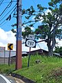
 PR-52 south at exit 21 to PR-172 in Cañaboncito, Caguas


| Municipality | Location | km[1] | mi | Destinations | Notes |
|---|---|---|---|---|---|
| Comerío | Naranjo | 0.0 | 0.0 | PR-156 – Comerío, Aguas Buenas | Western terminus of PR-172 |
| Vega Redonda | 3.6– 3.7 | 2.2– 2.3 |  PR-791 – Cejas PR-791 – Cejas | ||
| 5.4 | 3.4 |   PR-7774 west – Comerío PR-7774 west – Comerío | |||
| Cidra | Río Abajo | 9.4 | 5.8 |  PR-7775 – Rabanal PR-7775 – Rabanal | |
| Río Abajo–Ceiba– Rabanal tripoint | 11.5 | 7.1 |   PR-7733 east (Avenida de la Eterna Primavera) – Aibonito, Cayey PR-7733 east (Avenida de la Eterna Primavera) – Aibonito, Cayey | ||
| Cidra barrio-pueblo | 12.2 | 7.6 |   PR-173 south (Calle José Gautier Benítez) – Aibonito PR-173 south (Calle José Gautier Benítez) – Aibonito | Western terminus of PR-173 concurrency; one-way street | |
| 12.3 | 7.6 |  PR-173 north (Calle Román Baldorioty de Castro) – Aguas Buenas PR-173 north (Calle Román Baldorioty de Castro) – Aguas Buenas | Eastern terminus of PR-173 concurrency; one-way street; northbound access via Calle José Gautier Benítez or Calle Santiago R. Palmer | ||
| 12.4– 12.5 | 7.7– 7.8 |   PR-171 (Calle Luis Muñoz Rivera) / PR-734 south (Calle José de Diego) – Cayey PR-171 (Calle Luis Muñoz Rivera) / PR-734 south (Calle José de Diego) – Cayey | One-way streets; PR-734 access via Calle Miguel Planellas or Calle Vicente Muñoz Barrios | ||
| Bayamón–Arenas line | 13.6 | 8.5 | PR-7733 west (Avenida de la Eterna Primavera) – Cayey, Aibonito | ||
| 13.9 | 8.6 |  PR-787 – Las Cruces PR-787 – Las Cruces | |||
| Caguas | Cañaboncito | 20.9 | 13.0 |  PR-785 – Hormigas PR-785 – Hormigas | |
| 22.2 | 13.8 |  PR-784 – Cañaboncito PR-784 – Cañaboncito | |||
| Turabo–Cañaboncito line | 26.4 | 16.4 |  PR-7784 – Caguas PR-7784 – Caguas | ||
| 27.5 | 17.1 |  PR-52 (Autopista Luis A. Ferré) – San Juan, Ponce PR-52 (Autopista Luis A. Ferré) – San Juan, Ponce | PR-52 exit 21; diamond interchange | ||
| 27.7 | 17.2 |   PR-32 north (Avenida Luis Muñoz Marín) – Caguas PR-32 north (Avenida Luis Muñoz Marín) – Caguas | |||
| Caguas barrio-pueblo | 28.3 | 17.6 | PR-1 (Avenida José Gautier Benítez) – Caguas, Cayey | Eastern terminus of PR-172 | |
1.000 mi = 1.609 km; 1.000 km = 0.621 mi
| |||||
See also
 Puerto Rico portal
 U.S. Roads portal

References
- ^ a b Google (10 March 2020). "PR-172" (Map). Google Maps. Google. Retrieved 10 March 2020.
- ^ "Comerío, Memoria Núm. 41" (PDF). Puerto Rico Planning Board (in Spanish). 1955. Retrieved 4 August 2020.
- ^ National Geographic Maps (2011). Puerto Rico (Map). 1:125,000. Adventure Map (Book 3107). Evergreen, Colorado: National Geographic Maps. ISBN 978-1566955188. OCLC 756511572.
- ^ "Tránsito Promedio Diario (AADT)". Transit Data (Datos de Transito) (in Spanish). DTOP PR. p. 90. Archived from the original on 1 April 2019.
External links
 Media related to Puerto Rico Highway 172 at Wikimedia Commons
- v
- t
- e
 | This Puerto Rico road-related article is a stub. You can help Wikipedia by expanding it. |
- v
- t
- e


