Puerto Rico Highway 107
Highway in Puerto Rico
Major junctions
 PR-2 in Caimital Bajo
←  PR-106 PR-106 | →  PR-108 PR-108 |
←  PR-999 PR-999 | PR-1107 | →  PR-1111 PR-1111 |
Puerto Rico Highway 107 (PR-107), or Carretera Pedro Albizu Campos,[2] is a north–south highway located in Aguadilla, Puerto Rico.[3][4] It extends from PR-2 to Ramey Air Force Base.[5]
-
 Puerto Rico Highway 107 north near Crash Boat Beach

Major intersections
The entire route is located in Aguadilla.
| Location | km[1] | mi | Destinations | Notes | |
|---|---|---|---|---|---|
| Caimital Bajo | 0.0 | 0.0 | PR-2 – Arecibo, San Juan, Mayagüez | Southern terminus of PR-107 | |
| Caimital Bajo–Camaceyes line | 0.1– 0.2 | 0.062– 0.12 |   PR-1107 south (Avenida John F. Kennedy) PR-1107 south (Avenida John F. Kennedy) | Northern terminus of PR-1107 (former PR-111); access to Aguadilla Centro | |
| Camaceyes–Borinquen line | 0.5– 0.6 | 0.31– 0.37 |  To PR-1107 To PR-1107 | Access to Aguadilla Centro | |
| Borinquen | 0.9 | 0.56 |  PR-467 – Camaceyes PR-467 – Camaceyes | Clockwise terminus of PR-467 | |
| 1.9– 2.0 | 1.2– 1.2 |  PR-458 – Crash Boat Beach PR-458 – Crash Boat Beach | Eastern terminus of PR-458 | ||
| Borinquen–Camaceyes line | 4.1 | 2.5 |  PR-4467 – Malezas PR-4467 – Malezas | Western terminus of PR-4467 | |
| 4.5 | 2.8 | Ramey Air Force Base (Borinquen Road) | Northern terminus of PR-107 | ||
1.000 mi = 1.609 km; 1.000 km = 0.621 mi
| |||||
Related route
Highway 1107 | |
|---|---|
| Location | Aguadilla |
| Length | 6.3 km[6] (3.9 mi) |

Puerto Rico Highway 1107 (PR-1107) is a north–south spur route that connects PR-107 with downtown Aguadilla. This highways extends from PR-107 between Camaceyes and Caimital Bajo barrios until its end at PR-2 and PR-111 in Victoria. This highway was part of PR-111 and is designated as Carretera Doctor Gregorio Igartúa Acevedo.[7][8] The entire route is located in Aguadilla.
-
 PR-1107 south in downtown Aguadilla
 -
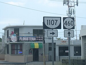 PR-1107 south at PR-460 intersection between Camaceyes and Caimital Bajo barrios


| Location | km[6] | mi | Destinations | Notes | |
|---|---|---|---|---|---|
| Victoria | 6.3 | 3.9 | PR-2 – Añasco, Mayagüez, Arecibo  PR-111 east – Moca, San Sebastián PR-111 east – Moca, San Sebastián | Partial cloverleaf interchange; southern terminus of PR-1107 and western terminus of PR-111 | |
| 6.2– 6.1 | 3.9– 3.8 |  PR-418 PR-418 | Northern terminus of PR-418 | ||
| 6.0 | 3.7 |  PR-4439 PR-4439 | Northern terminus of PR-4439 | ||
| 5.9 | 3.7 |  PR-115 – Aguada, Rincón PR-115 – Aguada, Rincón | Northern terminus of PR-115 | ||
| Aguadilla barrio-pueblo | 4.0 | 2.5 |  PR-4440 PR-4440 | Northern terminus of PR-4440 | |
| 3.8 | 2.4 | PR-4442 | Northern terminus of PR-4442; unsigned | ||
| 3.6 | 2.2 |   PR-440 north PR-440 north | Southern terminus of PR-440 | ||
| 3.1– 3.0 | 1.9– 1.9 |  PR-249 (Avenida San Carlos) PR-249 (Avenida San Carlos) | Former PR-2R | ||
| 2.8– 2.7 | 1.7– 1.7 | PR-440 south | Northern terminus of PR-440 | ||
| 2.2 | 1.4 |  PR-460 PR-460 | Southern terminus of PR-460 | ||
| Aguadilla barrio-pueblo–Camaceyes– Borinquen tripoint | 1.7– 1.6 | 1.1– 0.99 |  PR-4458 PR-4458 | Southern terminus of PR-4458 | |
| Camaceyes–Caimital Bajo line | 0.3– 0.2 | 0.19– 0.12 | PR-460 | Northern terminus of PR-460 | |
| 0.0 | 0.0 |   PR-107 (Avenida Doctor Pedro Albizu Campos) to PR-2 PR-107 (Avenida Doctor Pedro Albizu Campos) to PR-2 | Northern terminus of PR-1107; access to Arecibo, San Juan, Mayagüez and Ramey Air Force Base | ||
| 1.000 mi = 1.609 km; 1.000 km = 0.621 mi | |||||
See also
 Puerto Rico portal
 U.S. Roads portal

References
- ^ a b Google (2 March 2020). "PR-107" (Map). Google Maps. Google. Retrieved 2 March 2020.
- ^ "Av. Dr. Pedro Albizu Campos & PR-107". Google maps.
- ^ National Geographic Maps (2011). Puerto Rico (Map). 1:125,000. Adventure Map (Book 3107). Evergreen, Colorado: National Geographic Maps. ISBN 978-1566955188. OCLC 756511572.
- ^ "Listado NHS2008(Muestras).xls" (PDF). DTOP gov't of P.R. 5 November 2010. Archived from the original (PDF) on 5 November 2010.
- ^ "Tránsito Promedio Diario (AADT)". Transit Data (Datos de Transito) (in Spanish). DTOP PR. p. 58. Archived from the original on 1 April 2019.
- ^ a b Google (8 April 2023). "PR-1107" (Map). Google Maps. Google. Retrieved 8 April 2023.
- ^ "PR-111, Barrio Pueblo". mapio.net. Retrieved 9 April 2023.
- ^ "Resolución Conjunta Para denominar con el nombre del "Dr. Gregorio Igartúa Acevedo" la Carretera PR-1107 desde el Km.0.0, intersección con la Carretera PR-107 hasta el Km.6.30, intersección con las Carreteras PR-2 y PR-111 del Municipio de Aguadilla; y para otros fines relacionados". Cámara de Representantes de Puerto Rico (in Spanish). Retrieved 8 April 2023.
External links
Wikimedia Commons has media related to Puerto Rico Highway 107 and Puerto Rico Highway 1107.
- PR-107, Aguadilla, Puerto Rico
- v
- t
- e


