Portengen
Hamlet in Utrecht, Netherlands
52°09′21″N 4°57′48″E / 52.15583°N 4.96333°E / 52.15583; 4.96333 (2021)[1]
3628[1]
Portengen is a hamlet in the Dutch province of Utrecht. It is located in the municipality of Stichtse Vecht, 1 km (0.62 mi) northeast of Kockengen.
Portengen was a separate municipality from 1818 to 1857, when it was merged with Breukelen-Nijenrode.[3]
The hamlet was first mentioned in 1217 as Britannien, and is a reference to Brittany, France. It started as a peat excavation colony during the 11th and 12th century.[4] The hamlet of Portengensebrug is an enclave within Portengen. In 1840, Portengen was home to 55 people.[5]
Gallery
-
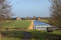 View on Portengensebrug
 -
 Pumping station Dooijersluis
 -
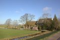 Farm in Portegen


References
- ^ a b c "Kerncijfers wijken en buurten 2021". Central Bureau of Statistics. Retrieved 27 March 2022.
- ^ "Postcodetool for 3628AA". Actueel Hoogtebestand Nederland (in Dutch). Het Waterschapshuis. Retrieved 27 March 2022.
- ^ Ad van der Meer and Onno Boonstra, Repertorium van Nederlandse gemeenten, KNAW, 2011.
- ^ "Portengen - (geografische naam)". Etymologiebank (in Dutch). Retrieved 27 March 2022.
- ^ "Portengen". Plaatsengids (in Dutch). Retrieved 27 March 2022.
Wikimedia Commons has media related to Portengen.
- v
- t
- e
Populated places in the municipality of Stichtse Vecht
- Kockengen
- Loenen aan de Vecht
- Loenersloot
- Nieuwersluis [nl]
- Nieuwer-Ter-Aa
- Nigtevecht
- Oud-Zuilen
- Tienhoven
- Vreeland
 | This Utrecht location article is a stub. You can help Wikipedia by expanding it. |
- v
- t
- e


