Pont de Neuilly
You can help expand this article with text translated from the corresponding article in French. (September 2022) Click [show] for important translation instructions.
- View a machine-translated version of the French article.
- Machine translation, like DeepL or Google Translate, is a useful starting point for translations, but translators must revise errors as necessary and confirm that the translation is accurate, rather than simply copy-pasting machine-translated text into the English Wikipedia.
- Consider adding a topic to this template: there are already 6,179 articles in the main category, and specifying
|topic=will aid in categorization. - Do not translate text that appears unreliable or low-quality. If possible, verify the text with references provided in the foreign-language article.
- You must provide copyright attribution in the edit summary accompanying your translation by providing an interlanguage link to the source of your translation. A model attribution edit summary is
Content in this edit is translated from the existing French Wikipedia article at [[:fr:Pont de Neuilly]]; see its history for attribution. - You may also add the template
{{Translated|fr|Pont de Neuilly}}to the talk page. - For more guidance, see Wikipedia:Translation.
Bridge in Courbevoie and Puteaux, France
48°53′12″N 2°15′17″E / 48.8867°N 2.2547°E / 48.8867; 2.2547(5 spans of 39 metres (128 ft))[1]

The Pont de Neuilly (English: Bridge of Neuilly) is a road and rail bridge carrying the Route nationale 13 (N13) and Paris Métro Line 1 which crosses the Seine between the right bank of Neuilly-sur-Seine and Courbevoie and Puteaux on the left bank in the department of Hauts-de-Seine. It faces the headquarters of La Défense and is aligned on the Axe historique of Paris.
History
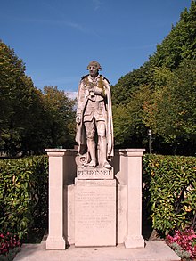
The first bridge on the site was in wood, built after the fall of Henry IV and Marie de Médicis's carriage in June 1606. The second was a 219m-long five-arched structure built in 1774 by Jean-Rodolphe Perronet, founder of the École des ponts et chaussées (a stone statue of him is now at the foot of the bridge, at the west point of the Île de Puteaux). The second bridge was demolished between 1936 and 1942 and replaced in 1942 with a metal bridge by Louis-Alexandre Lévy and the Daydé company. In 1992, its pedestrian sidewalks were narrowed to allow Line 1 to be added to the bridge and the bridge gave its name to the nearby Métro station.
The present bridge effectively consisted of two bridges: a 67 metre span between Neuilly-sur-Seine and the Île de Puteaux, as well as an 87 metre span between the Île de Puteaux and Courbevoie. A pedestrian staircase in the middle of the bridge allows access to the Île de Puteaux.
References
Wikimedia Commons has media related to Pont de Neuilly.
- ^ "Neuilly bridge". Structurae—International Database for Civil and Structural Engineering. Retrieved 26 October 2014.
- v
- t
- e
Paris Métro bridges
- Pont de Bercy
- Pont de Bir-Hakeim
- Pont Morland
- Viaduc d'Austerlitz
- Pont de Neuilly
- Viaduc de Clichy
- Viaduc de Charenton
| Authority control databases: Geographic |
|
|---|
48°53′12″N 2°15′17″E / 48.88667°N 2.25472°E / 48.88667; 2.25472


