Peyrolles-en-Provence
Commune in Provence-Alpes-Côte d'Azur, France
You can help expand this article with text translated from the corresponding article in French. (October 2021) Click [show] for important translation instructions.
- View a machine-translated version of the French article.
- Machine translation, like DeepL or Google Translate, is a useful starting point for translations, but translators must revise errors as necessary and confirm that the translation is accurate, rather than simply copy-pasting machine-translated text into the English Wikipedia.
- Do not translate text that appears unreliable or low-quality. If possible, verify the text with references provided in the foreign-language article.
- You must provide copyright attribution in the edit summary accompanying your translation by providing an interlanguage link to the source of your translation. A model attribution edit summary is
Content in this edit is translated from the existing French Wikipedia article at [[:fr:Peyrolles-en-Provence]]; see its history for attribution. - You may also add the template
{{Translated|fr|Peyrolles-en-Provence}}to the talk page. - For more guidance, see Wikipedia:Translation.
Commune in Provence-Alpes-Côte d'Azur, France
Peyrolles-en-Provence Peiròla de Provença (Occitan) | ||
|---|---|---|
Commune | ||
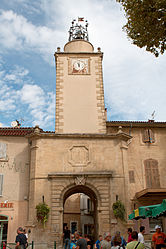 The 17th-century bell tower in the town centre of Peyrolles-en-Provence | ||
 Coat of arms | ||
Location of Peyrolles-en-Provence  | ||
(2020–2026) Olivier Frégeac[1] | | |
| Area 1 | 34.9 km2 (13.5 sq mi) | |
| Population (2021)[2] | 5,223 | |
| • Density | 150/km2 (390/sq mi) | |
| Time zone | UTC+01:00 (CET) | |
| • Summer (DST) | UTC+02:00 (CEST) | |
| INSEE/Postal code | 13074 /13860 | |
| Elevation | 201–782 m (659–2,566 ft) (avg. 220 m or 720 ft) | |
| 1 French Land Register data, which excludes lakes, ponds, glaciers > 1 km2 (0.386 sq mi or 247 acres) and river estuaries. | ||
Peyrolles-en-Provence (French pronunciation: [pɛʁɔl ɑ̃ pʁɔvɑ̃s]; Occitan: Peiròla de Provença) is a commune in the Bouches-du-Rhône department in the Provence-Alpes-Côte d'Azur region in Southern France. Part of the Aix-Marseille-Provence Metropolis, it is located 18 km (11.2 mi) northeast of Aix-en-Provence. In 2018, Peyrolles-en-Provence had a population of 5,125.
Demographics
|
| ||||||||||||||||||||||||||||||||||||||||||||||||||||||||||||||||||||||||||||||||||||||||||||||||||||||||||||||||||
| Source: EHESS[3] and INSEE (1968-2017)[4] | |||||||||||||||||||||||||||||||||||||||||||||||||||||||||||||||||||||||||||||||||||||||||||||||||||||||||||||||||||
Climate
On average, Peyrolles-en-Provence experiences 59.3 days per year with a minimum temperature below 0 °C (32.0 °F), 0.8 days per year with a minimum temperature below −10 °C (14.0 °F), 0.4 days per year with a maximum temperature below 0 °C (32.0 °F), and 66.8 days per year with a maximum temperature above 30 °C (86.0 °F). The record high temperature was 44.4 °C (111.9 °F) on 28 June 2019, while the record low temperature was −14.1 °C (6.6 °F) on 12 February 2012.[5]
| Climate data for Peyrolles-en-Provence (1991–2020 normals, extremes 2005–present) | |||||||||||||
|---|---|---|---|---|---|---|---|---|---|---|---|---|---|
| Month | Jan | Feb | Mar | Apr | May | Jun | Jul | Aug | Sep | Oct | Nov | Dec | Year |
| Record high °C (°F) | 20.1 (68.2) | 23.3 (73.9) | 26.1 (79.0) | 29.2 (84.6) | 34.3 (93.7) | 44.4 (111.9) | 38.9 (102.0) | 41.5 (106.7) | 35.5 (95.9) | 31.3 (88.3) | 23.4 (74.1) | 21.6 (70.9) | 44.4 (111.9) |
| Mean daily maximum °C (°F) | 11.3 (52.3) | 12.6 (54.7) | 16.3 (61.3) | 20.1 (68.2) | 24.0 (75.2) | 29.0 (84.2) | 32.4 (90.3) | 31.6 (88.9) | 26.9 (80.4) | 21.5 (70.7) | 15.4 (59.7) | 11.3 (52.3) | 21.0 (69.9) |
| Daily mean °C (°F) | 5.9 (42.6) | 6.4 (43.5) | 9.6 (49.3) | 13.0 (55.4) | 16.6 (61.9) | 21.0 (69.8) | 23.8 (74.8) | 23.0 (73.4) | 19.4 (66.9) | 15.1 (59.2) | 9.9 (49.8) | 6.0 (42.8) | 14.1 (57.5) |
| Mean daily minimum °C (°F) | 0.5 (32.9) | 0.2 (32.4) | 2.9 (37.2) | 6.0 (42.8) | 9.3 (48.7) | 12.9 (55.2) | 15.2 (59.4) | 14.5 (58.1) | 11.9 (53.4) | 8.8 (47.8) | 4.5 (40.1) | 0.7 (33.3) | 7.3 (45.1) |
| Record low °C (°F) | −10.1 (13.8) | −14.1 (6.6) | −7.7 (18.1) | −4.5 (23.9) | −1.2 (29.8) | 1.5 (34.7) | 6.8 (44.2) | 5.6 (42.1) | 1.7 (35.1) | −4.1 (24.6) | −8.0 (17.6) | −11.0 (12.2) | −14.1 (6.6) |
| Average precipitation mm (inches) | 48.3 (1.90) | 37.4 (1.47) | 36.9 (1.45) | 49.0 (1.93) | 49.3 (1.94) | 47.6 (1.87) | 22.6 (0.89) | 30.4 (1.20) | 54.1 (2.13) | 81.0 (3.19) | 84.5 (3.33) | 54.3 (2.14) | 595.4 (23.44) |
| Average precipitation days (≥ 1.0 mm) | 5.1 | 6.1 | 6.1 | 6.8 | 6.2 | 4.1 | 2.2 | 3.3 | 4.6 | 5.1 | 6.8 | 5.6 | 62.0 |
| Source: Meteociel[5] | |||||||||||||
See also
References
- ^ "Répertoire national des élus: les maires" (in French). data.gouv.fr, Plateforme ouverte des données publiques françaises. 13 September 2022.
- ^ "Populations légales 2021". The National Institute of Statistics and Economic Studies. 28 December 2023.
- ^ Des villages de Cassini aux communes d'aujourd'hui: Commune data sheet Peyrolles-en-Provence, EHESS (in French).
- ^ Population en historique depuis 1968, INSEE
- ^ a b "1991–2020 Normals and Records – Station: Peyrolles-en-Provence". Meteociel.fr. Retrieved 6 September 2023.
External links
- Official website (in French)
Wikimedia Commons has media related to Peyrolles-en-Provence.
- v
- t
- e

- Aix-en-Provencesubpr
- Allauch
- Alleins
- Arlessubpr
- Aubagne
- Aureille
- Auriol
- Aurons
- La Barben
- Barbentane
- Les Baux-de-Provence
- Beaurecueil
- Belcodène
- Berre-l'Étang
- Bouc-Bel-Air
- La Bouilladisse
- Boulbon
- Cabannes
- Cabriès
- Cadolive
- Carnoux-en-Provence
- Carry-le-Rouet
- Cassis
- Ceyreste
- Charleval
- Châteauneuf-le-Rouge
- Châteauneuf-les-Martigues
- Châteaurenard
- La Ciotat
- Cornillon-Confoux
- Coudoux
- Cuges-les-Pins
- La Destrousse
- Éguilles
- Ensuès-la-Redonne
- Eygalières
- Eyguières
- Eyragues
- La Fare-les-Oliviers
- Fontvieille
- Fos-sur-Mer
- Fuveau
- Gardanne
- Gémenos
- Gignac-la-Nerthe
- Grans
- Graveson
- Gréasque
- Istressubpr
- Jouques
- Lamanon
- Lambesc
- Lançon-Provence
- Maillane
- Mallemort
- Marignane
- Marseillepref
- Martigues
- Mas-Blanc-des-Alpilles
- Maussane-les-Alpilles
- Meyrargues
- Meyreuil
- Mimet
- Miramas
- Mollégès
- Mouriès
- Noves
- Orgon
- Paradou
- Pélissanne
- Les Pennes-Mirabeau
- La Penne-sur-Huveaune
- Peynier
- Peypin
- Peyrolles-en-Provence
- Plan-de-Cuques
- Plan-d'Orgon
- Port-de-Bouc
- Port-Saint-Louis-du-Rhône
- Puyloubier
- Le Puy-Sainte-Réparade
- Rognac
- Rognes
- Rognonas
- La Roque-d'Anthéron
- Roquefort-la-Bédoule
- Roquevaire
- Rousset
- Le Rove
- Saint-Andiol
- Saint-Antonin-sur-Bayon
- Saint-Cannat
- Saint-Chamas
- Saintes-Maries-de-la-Mer
- Saint-Estève-Janson
- Saint-Étienne-du-Grès
- Saint-Marc-Jaumegarde
- Saint-Martin-de-Crau
- Saint-Mitre-les-Remparts
- Saint-Paul-lès-Durance
- Saint-Pierre-de-Mézoargues
- Saint-Rémy-de-Provence
- Saint-Savournin
- Saint-Victoret
- Salon-de-Provence
- Sausset-les-Pins
- Sénas
- Septèmes-les-Vallons
- Simiane-Collongue
- Tarascon
- Le Tholonet
- Trets
- Vauvenargues
- Velaux
- Venelles
- Ventabren
- Vernègues
- Verquières
- Vitrolles
- pref: prefecture
- subpr: subprefecture
Authority control databases | |
|---|---|
| International |
|
| National |
|


