Petit Morin
River in France
| Petit Morin | |
|---|---|
 | |
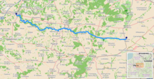 Path of the Petit Morin [1] | |
| Location | |
| Country | France |
| Physical characteristics | |
| Source | |
| • location | Champagne |
| Mouth | |
• location | Marne |
• coordinates | 48°56′38″N 3°7′20″E / 48.94389°N 3.12222°E / 48.94389; 3.12222 |
| Length | 86 km (53 mi) |
| Basin features | |
| Progression | Marne→ Seine→ English Channel |
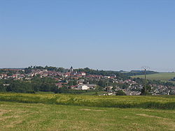
The Petit Morin (French pronunciation: [pəti mɔʁɛ̃], literally Little Morin) is an 86 km-long (53 mi) river in France, a left tributary of the Marne.[1] Its source is in the commune Val-des-Marais. Its course crosses the departments of Marne, Aisne and Seine-et-Marne. It flows westwards through the towns of Montmirail, Villeneuve-sur-Bellot, Saint-Cyr-sur-Morin and Jouarre, finally flowing into the Marne in La Ferté-sous-Jouarre.
References
Authority control databases | |
|---|---|
| International |
|
| National |
|
| Other |
|
- v
- t
- e
 | This Hauts-de-France geographical article is a stub. You can help Wikipedia by expanding it. |
- v
- t
- e
 | This Île-de-France geographical article is a stub. You can help Wikipedia by expanding it. |
- v
- t
- e
This article related to a river in France is a stub. You can help Wikipedia by expanding it. |
- v
- t
- e


