Pakur, Hooghly
Village in West Bengal, India
22°43′11″N 88°11′41″E / 22.7196402°N 88.1946309°E / 22.7196402; 88.1946309 India
India (2011)
712702 (Mosat)
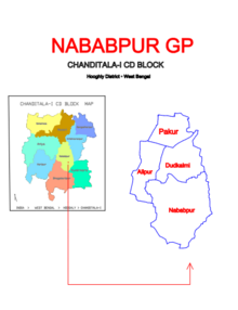
Pakur is a village in Chanditala I community development block of Srirampore subdivision in Hooghly district in the Indian state of West Bengal.[1]
Geography
Pakur is located at 22°43′11″N 88°11′41″E / 22.7196402°N 88.1946309°E / 22.7196402; 88.1946309.
Gram panchayat
Villages and census towns in Nababpur gram panchayat, in addition to Pakur, are: Alipur, Dudhkalmi and Nababpur.[2]
Demographics
As per 2011 Census of India Pakur had a population of 3,997 of which 1,939 (49%) were males and 2,058 (51%) were females. Population below 6 years was 346. The number of literates in Pakur was 3,161 (86.58% of the population over 6 years).[3]
Culture
Pakur Tarun Sahitya Mandir is a rural library established in 1943.[4]
References
- ^ "banglarbhumi.gov.in". WEST BENGAL ->HUGLI(হুগলী) ->CHANDITALA-I (চণ্ডীতলা-১) Mouza Information. Archived from the original on 22 December 2016.
- ^ "Pakur". Indian Village Directory. Retrieved 12 October 2018.
- ^ "C.D. Block Wise Primary Census Abstract Data(PCA)". 2011 census: West Bengal – District-wise CD Blocks. Registrar General and Census Commissioner, India. Retrieved 7 October 2018.
- ^ "Pakur Tarun Sahitya Mandir". Entranceindia. Retrieved 6 October 2018.
- v
- t
- e
Cities, towns and locations in Srirampore subdivision
and villages
 India portal

 | This article about a location in the Hooghly district of West Bengal is a stub. You can help Wikipedia by expanding it. |
- v
- t
- e


