Oud-Loosdrecht
Village in North Holland, Netherlands
52°12′N 5°5′E / 52.200°N 5.083°E / 52.200; 5.083 (2021)[1]
1231[1]
Oud-Loosdrecht is a village in the province of North Holland, Netherlands. It is a part of the town of Loosdrecht and the municipality of Wijdemeren; it lies about 6 km west of Hilversum.
History
The village was first mentioned in 1384 as "van der Loesdrecht". The current name means "old ferry over the drainage canal". Oud (old) has been added to distinguish from Nieuw-Loosdrecht.[3][4]
It contains a large amount of Rijksmonumenten.[5]
Gallery
-
 Fort Spion
 -
 View on Loosdrechtse Plassen lake along the Veendijk
 -
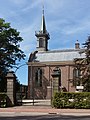 Church of Oud-Loosdrecht
 -
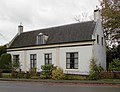 Rijksmonument on the Oud-Loosdrechtsedijk


References
- ^ a b c "Kerncijfers wijken en buurten 2021". Central Bureau of Statistics. Retrieved 2 May 2022.
- ^ "Postcodetool for 1231AA". Actueel Hoogtebestand Nederland (in Dutch). Het Waterschapshuis. Retrieved 2 May 2022.
- ^ "Oud-Loosdrecht - (geografische naam)". Etymologiebank (in Dutch). Retrieved 2 May 2022.
- ^ "Loosdrecht - (geografische naam)". Etymologiebank (in Dutch). Retrieved 2 May 2022.
- ^ "Oud-Loosdrecht". Plaatsengids (in Dutch). Retrieved 2 May 2022.
- v
- t
- e
Populated places in the municipality of Wijdemeren
- Ankeveen
- 's-Graveland
- Kortenhoef
- Nederhorst den Berg
- Nieuw-Loosdrecht
- Oud-Loosdrecht
| Authority control databases: Geographic |
|
|---|


