Otxarkoaga-Txurdinaga
District in Basque Country, Spain
Otxarkoaga-Txurdinaga | |
|---|---|
District | |
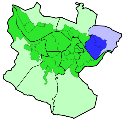 Otxarkoaga-Txurdinaga district is highlighted in blue in this map of the districts of Bilbao. | |
| Country | Spain |
| Autonomous community | Basque Country |
| Province | Biscay |
| Comarca | Greater Bilbao |
| Municipality | Bilbao |
| Area | |
| • Total | 3.90 km2 (1.51 sq mi) |
| Population (2016) | |
| • Total | 26,458 |
| • Density | 6,800/km2 (18,000/sq mi) |
Otxarkoaga-Txurdinaga is the third district of the city of Bilbao (Biscay), in the Spanish Basque Country. It is divided into the neighbourhoods of Otxarkoaga and Txurdinaga.[1] It has an area of 389.94 hectares and a population of 26,458 inhabitants (2016), being one of the least densely populated districts of the city.
History
These two neighbourhoods were historically part of the old parish of Begoña. In these areas existed vineyards for the elaboration of the traditional Txakoli white wine, this has given the inhabitants the nickname of Matxorris, from Basque language Mahats=grape and orri=plant.
The Basque Football Federation has its offices in the area, on Julian Gaiarre Etorbidea.
Transport
The Bilbobus and BizkaiBus bus lines have stops in the district. In 2017, line 3 of the Bilbao metro opened, with the Otxarkoaga and Txurdinaga stations in the district.
Sights
-
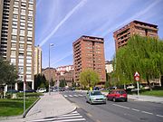 Gabriel Aresti avenue in Txurdinaga.

References
- ^ "Plano Callejero" (PDF). Bilbao City Council. Retrieved 2007-10-15.
- v
- t
- e
Districts of Bilbao
- 1 Deusto
- Arangoiti
- Ibarrekolanda
- San Ignacio-Elorrieta
- San Pedro de Deusto-La Rivera
- 3 Otxarkoaga-Txurdinaga
- Otxarkoaga
- Txurdinaga
- 5 Ibaiondo
- Atxuri
- Bilbao La Vieja
- Casco Viejo
- Iturralde
- La Peña
- Miribilla
- San Adrián
- San Frantzisko
- Solokoetxe
- Zabala
- 7 Errekalde
- Ametzola
- Errekaldeberri-Larraskitu
- Iralabarri
- Iturrigorri-Peñascal
- Uretamendi
- 8 Basurto-Zorroza
- Altamira
- Basurtu
- Masustegi-Monte Caramelo
- Olabeaga
- Zorrotza

43°15′30″N 2°54′10″W / 43.25833°N 2.90278°W / 43.25833; -2.90278


