Newkirk Plaza station
New York City Subway station in Brooklyn
New York City Subway station in Brooklyn, New York
B  (weekday rush hours, middays and early evenings)
 Q
 (all times)
 NYCT Bus: B8
cross-platform interchange
direction
transfer
South Midwood (????-1908)
Newkirk Avenue (1908-2011)
 7.4%
7.4%| Services | ||||||||||||||||
|---|---|---|---|---|---|---|---|---|---|---|---|---|---|---|---|---|
| ||||||||||||||||
| Location |
|---|
    |
| Track layout | |||||||||||||||||||||||||||||||||||||||||||||||||||||||||||||||||||||||||||||||||||||||||||||
|---|---|---|---|---|---|---|---|---|---|---|---|---|---|---|---|---|---|---|---|---|---|---|---|---|---|---|---|---|---|---|---|---|---|---|---|---|---|---|---|---|---|---|---|---|---|---|---|---|---|---|---|---|---|---|---|---|---|---|---|---|---|---|---|---|---|---|---|---|---|---|---|---|---|---|---|---|---|---|---|---|---|---|---|---|---|---|---|---|---|---|---|---|---|
|
| |||||||||||||||||||||||||||||||||||||||||||||||||||||||||||||||||||||||||||||||||||||||||||||


| Street map |
|---|
|
|

| Station service legend | |
|---|---|
| Symbol | Description |
| Stops all times |
| Stops weekdays during the day |
The Newkirk Plaza station is an express station on the BMT Brighton Line of the New York City Subway in Flatbush, Brooklyn. It is located on an open-cut at the center of the pedestrian-only Newkirk Plaza shopping mall, which is bounded by Newkirk Avenue on the north, Foster Avenue on the south, Marlborough Road to the west, and East 16th Street to the east. The station is served by the Q train at all times and by the B train on weekdays only.
History
The station opened around 1900 as a two-track surface station named South Midwood, a reference to its location at the southern end of the former Town of Flatbush, which was also historically known as Midwood. Currently, Midwood is considered to be the area south of where the station now stands, so it would now more correctly be described as being in South Flatbush or North Midwood. The station was located along the Brooklyn, Flatbush and Coney Island Railroad line to Brighton Beach, which was built in 1878.[3]
In 1903, a reconstruction project began to remove grade crossings along the line as part of the "Brighton Beach Improvement," which also rebuilt stations of the Brighton Beach Line and electrified the line due to increased ridership on the line.[3] When on the surface, the station was a division point at which short turned elevated trains of the Fulton Street El terminated. After grade crossings on the line were eliminated in 1908, the station became a through stop for all services; at this time it was given the name Newkirk Avenue.[3] On the eastern side of the station entrance building there is a plaque, which reads: "The Depression and Elevation of this railroad to abolish grade crossings was authorized by the Legislature May 9th, 1903. A joint undertaking between the City Of New York and the Brooklyn Heights R.R. Co. under the direction of the Brooklyn Grade Crossing Commission. ..... Work commenced August 1st 1904 - Completed July 1st 1908." This plaque refers to the aforementioned grade crossing project.[citation needed]
During the 1964–1965 fiscal year, the platforms at Newkirk Avenue, along with those at six other stations on the Brighton Line, were lengthened to 615 feet (187 m) to accommodate a ten-car train of 60 foot (18 m)-long IND cars, or a nine-car train of 67 foot (20 m)-long BMT cars.[4]
In 1981, the Metropolitan Transportation Authority listed the station among the 69 most deteriorated stations in the subway system.[5] Starting in the late 1980s or early 1990s, business owners in the adjoining shopping area began advocating for the station to be renamed after the mall.[6] The station and mall underwent reconstruction from 2009 to 2011. This included installation of yellow warning strips on the platform edges and repainting of the columns from red to green.[7] The renovation cost $30 million.[8] As part of the renovation of the station, it was renamed Newkirk Plaza in August 2011.[6]
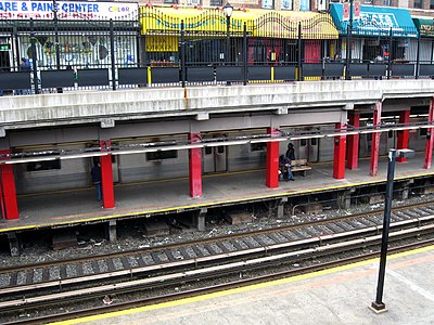
Station layout
| G | Street level | Entrances/exits, station house and agent, MetroCard machines, Newkirk Plaza shops |
| P Platform level | Northbound local | ←  toward 96th Street (Cortelyou Road) toward 96th Street (Cortelyou Road) |
| Island platform | ||
| Northbound express | ←  weekdays toward Bedford Park Boulevard or 145th Street (Church Avenue) weekdays toward Bedford Park Boulevard or 145th Street (Church Avenue) | |
| Southbound express | ← weekdays toward Brighton Beach (Kings Highway) → | |
| Island platform | ||
| Southbound local | ← toward Coney Island–Stillwell Avenue (Avenue H) → | |

This open-cut station has four tracks and two island platforms, typical for a New York City Subway express station.[9] Two pairs of I-beam columns run along the lengths of both platforms. The Q stops here at all times and is local, while the B stops here only on weekdays during the day and is express. The next stop to the north is Cortelyou Road for local trains and Church Avenue for express trains, while the next stop to the south is Avenue H for local trains and Kings Highway for express trains.[10]
Newkirk Plaza mall
Directly above the station is the Newkirk Plaza shopping area, which is located on either side of a pedestrian walkway above the station.[8] The mall opened in 1913,[8] shortly after the current station did.[11] The shopping area is of an open-air format and all the stores face a passageway that is owned and maintained by the New York City Department of Transportation; however, the stores are privately owned. Many of the stores there are small family-owned businesses,[11] lending the area a "small-town feel."[8] Since the late 2000s, there have been efforts to create a business improvement district for the shopping area.[6]
The Manhattan-bound local track is completely underneath the east side of the mall while the Coney Island-bound one is underneath the west side of the mall except for a section at the north end. The express tracks are in open view except in the center (where the station's only entrance is) and at either ends (where the Newkirk and Foster Avenues overpasses are).[citation needed]
Exit
The station's only entrance and exit is a station house at the center of the plaza. It has a token booth, turnstile bank, and a staircase leading to a short landing above both platforms that separate into two staircases facing the opposite directions going down to the platforms themselves. The station house was renovated in 1988, which included installation of white tiles and a stained-glass artwork titled Transit Skylight by David Wilson. The station house is located on Newkirk Avenue's south side between East 15th and East 16th Streets.[12]
In popular culture
This station appeared in the Futurama episode "The Luck of the Fryrish" and was portrayed as being in Fry's old neighborhood of Ditmas Park, considering his old home is a detached albeit run-down Victorian house. It also appeared in the films Next Stop, Greenwich Village, and Man Push Cart.[13]
Gallery
-
 Newkirk Plaza and station before the renaming
 -
 New sign and green columns after renovation
 -
 B train of R68As arriving
 -
 Q train of R160s arriving


References
- ^ "Glossary". Second Avenue Subway Supplemental Draft Environmental Impact Statement (SDEIS) (PDF). Vol. 1. Metropolitan Transportation Authority. March 4, 2003. pp. 1–2. Archived from the original (PDF) on February 26, 2021. Retrieved January 1, 2021.
- ^ a b "Annual Subway Ridership (2018–2023)". Metropolitan Transportation Authority. 2023. Retrieved April 20, 2024.
- ^ a b c Brooklyn Grade Crossing Commission (January 1, 1918). HISTORY of the work of eliminating grade crossings BY THE Brooklyn Grade Crossing Commission, a joint undertaking between THE CITY OF NEW YORK, THE LONG ISLAND R. R. CO., THE LONG ISLAND R. R. CO. AND THE BROOKLYN HEIGHTS R. R. CO. April 30, 1915. [New York : s.n].
- ^ Annual Report 1964–1965. New York City Transit Authority. 1965.
- ^ Gargan, Edward A. (June 11, 1981). "AGENCY LISTS ITS 69 MOST DETERIORATED SUBWAY STATIONS". The New York Times. Retrieved August 13, 2016.
- ^ a b c Klein, Helen (March 20, 2008). "Newkirk name change - Transit Authority considers merchants' 'Plaza' request". timesledger.com. Times Ledger. Retrieved August 5, 2016.
- ^ "Press Release - NYC Transit - Temporary Loss of Brighton Line Express". Metropolitan Transportation Authority. July 29, 2009. Archived from the original on August 12, 2017. Retrieved August 11, 2017.
- ^ a b c d Grynbaum, Michael M. (August 28, 2009). "Newkirk Plaza in Ditmas Plaza Struggles With Renovation Project". The New York Times. ISSN 0362-4331. Retrieved August 5, 2016.
- ^ Dougherty, Peter (2006) [2002]. Tracks of the New York City Subway 2006 (3rd ed.). Dougherty. OCLC 49777633 – via Google Books.
- ^ "Subway Map" (PDF). Metropolitan Transportation Authority. September 2021. Retrieved September 17, 2021.
- ^ a b Brooks of Sheffield (November 21, 2008). "Lost City: Welcome to Newkirk Plaza". lostnewyorkcity.blogspot.com. Lost City. Retrieved August 5, 2016.
- ^ "MTA Neighborhood Maps: Flatbush" (PDF). mta.info. Metropolitan Transportation Authority. 2015. Retrieved August 2, 2015.
- ^ Films, Documentaries, & Television (NYCSubway.org)
External links
 Media related to Newkirk Plaza (BMT Brighton Line) at Wikimedia Commons
- nycsubway.org – BMT Brighton Line: Newkirk Avenue
- Station Reporter — B Train
- Station Reporter — Q Train
- MTA's Arts For Transit — Newkirk Plaza (BMT Brighton Line)
- The Subway Nut — Newkirk Plaza Pictures
- Unofficial webpage from newkirkplaza.net
- Globe lamps on Newkirk Avenue from Google Maps Street View
- Globe lamps on Foster Avenue from Google Maps Street View
- Entrance from Google Maps Street View
- Platforms from Google Maps Street View
- v
- t
- e
Sixth Avenue Express- Bedford Park Boulevard
- Kingsbridge Road
- Fordham Road
- 182nd–183rd Streets
- Tremont Avenue
- 174th–175th Streets
- 170th Street
- 167th Street
- 161st Street–Yankee Stadium
- 155th Street
- 145th Street
- 135th Street
- 125th Street
- 116th Street
- Cathedral Parkway–110th Street
- 103rd Street
- 96th Street
- 86th Street
- 81st Street–Museum of Natural History
- 72nd Street
- 59th Street–Columbus Circle
- Seventh Avenue
- 47th–50th Streets–Rockefeller Center
- 42nd Street–Bryant Park
- 34th Street–Herald Square
- West Fourth Street–Washington Square
- Broadway–Lafayette Street
- Grand Street
- DeKalb Avenue
- Atlantic Avenue–Barclays Center
- Seventh Avenue
- Prospect Park
- Church Avenue
- Newkirk Plaza
- Kings Highway
- Sheepshead Bay
- Brighton Beach
Second Avenue/Broadway Express/
Brighton Local
- 96th Street
- 86th Street
- 72nd Street
- Lexington Avenue–63rd Street
- 57th Street–Seventh Avenue
- 49th Street*
- Times Square–42nd Street
- 34th Street–Herald Square
- 28th Street*
- 23rd Street*
- 14th Street–Union Square
- Eighth Street–New York University*
- Prince Street*
- Canal Street
- DeKalb Avenue
- Atlantic Avenue–Barclays Center
- Seventh Avenue
- Prospect Park
- Parkside Avenue
- Church Avenue
- Beverley Road
- Cortelyou Road
- Newkirk Plaza
- Avenue H
- Avenue J
- Avenue M
- Kings Highway
- Avenue U
- Neck Road
- Sheepshead Bay
- Brighton Beach
- Ocean Parkway
- West Eighth Street–New York Aquarium
- Coney Island–Stillwell Avenue
- See also
- Lists by borough (The Bronx
- Brooklyn
- Manhattan
- Queens)
- Accessible
- Closed
- Terminals
- Transfer
- Commons category
- Note: Service variations, station closures, and reroutes are not reflected here.
Stations with asterisks have no regular peak, reverse peak, or midday service on that route. See linked articles for more information.
| |
|---|---|
| Brighton Line |
|
| |


