Nevado de Toluca
Stratovolcano in central Mexico

Nevado de Toluca
Location in Mexico
Show map of State of Mexico
Nevado de Toluca
Nevado de Toluca (Mexico)
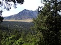
Show map of MexicoNevado de Toluca (Spanish: [neˈβaðo ðe toˈluka] ⓘ) is a stratovolcano in central Mexico, located about 80 kilometres (50 mi) west of Mexico City near the city of Toluca. It is the fourth highest of Mexico's peaks, after Pico de Orizaba, Popocatépetl and Iztaccíhuatl. The volcano and the area around it is now a national park.
Etymology
It is often called by the Nahuatl name Xinantecatl which is usually translated as The Naked Lord, Señor Desnudo in Spanish, although other etymologies have been suggested such as "Lord of the Corn Stalks" (Chinantecatl),[3] Tzinacantepetl (Mountain of the Bats), or Tzinacantecatl (person from Zinacantepec). Further evidence regarding the etymologies of this mountain has surfaced after many archeology discoveries in and around the area. It has been concluded that its correct etymology is Chicnauhtecatl meaning "Lord of Nine", probably referring to the various deep lakes at the top of the cone.[4]
Description

The volcano has a 1.5-kilometre (0.93 mi) wide summit caldera which is open to the east. The highest summit, the 4,680-metre (15,354 ft) Pico del Fraile (Friar's Peak), is on the southwest side of the crater and the second highest, the 4,640-metre (15,223 ft) Pico del Aguila (Eagle's Peak), is on the northwest.
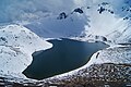
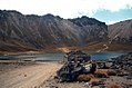
There are two crater lakes on the floor of the basin at about 4,200 m (13,800 ft), the larger Lago del Sol (Sun Lake) and the smaller, but deeper, Lago de la Luna (Moon Lake).[5]
A road formerly ran into the caldera to the lakes, but is now gated 2 km before the lakes.[citation needed]
From the southeast, Nevado de Toluca looks flat-topped, like shoulders without a head. A Nahuatl legend (recounted as part of the legend of Popocatépetl and Iztaccíhuatl) provides a mythical explanation.[6]

Geology
It is believed that Nevado de Toluca may once have been as tall as Popocatépetl, until an enormous eruption nearly 25,000 years ago blasted the top of the cone off and reduced its height by as much as 900 m (3,000 ft).[5] The same eruption generated thick lahars, or mudflows, which coated the sides of the mountains. An eruption approximately 500 years later deposited layers of pumice on the mountain's east and northeast slopes.[5]
The last major eruption of Nevado de Toluca occurred about 10,500 years ago (10.5 ka BP), as the volcano erupted a total estimated volume of 20 km3 for a VEI strength of 6 (comparable to the 1991 eruption of Mount Pinatubo). The eruption emplaced 1.5 m (5 ft) of pebble-sized pumice in the City of Toluca region and ~50 cm (2 ft) of medium to fine sand in the Mexico City region. Distal lahar deposits derived from the Upper Toluca Pumice event incorporated mammoth bones and other mammals in the basin of Mexico.
The volcano became inactive after a volcanic plug formed in the volcano's vent. The plug eventually became known as El Ombligo ("the Navel").[5]
Climate
Near the summit, Nevado de Toluca has a cold alpine climate (Köppen climate classification ET) with cold temperatures year round. There is little variation in the temperatures and frost and snow can occur in any month. The winter season covers from November to April and precipitation is low, averaging 7.5 millimetres (0.5 in) in March, the driest month.[7] Temperatures during this time are cold, averaging 2.3 °C (36.1 °F) in January. The summer season spans from May to October and precipitation is very high, averaging 235.4 millimetres (9.5 in) in July. Temperatures during this time are warm, averaging 5.3 °C (41.5 °F) in May. The summit is often foggy, averaging 78 days with fog, most of it during the monsoon season.[7] The wettest record month was July 2008 when 513.5 millimetres (20 in) of precipitation fell and the wettest recorded day was July 16, 1999 when 90.5 millimetres (3.5 in) of precipitation fell. The highest temperature ever recorded was 23 °C (73.4 °F) on August 16, 1993, and the lowest temperature recorded was −10 °C (14.0 °F) on February 2, 2004.
| Climate data for Nevado de Toluca (4283 m) (1981-2010 normals, extremes 1964-2019) | |||||||||||||
|---|---|---|---|---|---|---|---|---|---|---|---|---|---|
| Month | Jan | Feb | Mar | Apr | May | Jun | Jul | Aug | Sep | Oct | Nov | Dec | Year |
| Record high °C (°F) | 15.0 (59.0) | 16.5 (61.7) | 19.0 (66.2) | 19.0 (66.2) | 19.3 (66.7) | 19.0 (66.2) | 21.0 (69.8) | 23.0 (73.4) | 16.0 (60.8) | 19.0 (66.2) | 14.0 (57.2) | 13.0 (55.4) | 23.0 (73.4) |
| Mean daily maximum °C (°F) | 7.4 (45.3) | 8.2 (46.8) | 9.8 (49.6) | 10.5 (50.9) | 10.1 (50.2) | 9.6 (49.3) | 8.6 (47.5) | 8.5 (47.3) | 8.2 (46.8) | 8.2 (46.8) | 7.8 (46.0) | 7.5 (45.5) | 8.7 (47.7) |
| Daily mean °C (°F) | 2.3 (36.1) | 2.9 (37.2) | 4.4 (39.9) | 5.3 (41.5) | 5.3 (41.5) | 5.2 (41.4) | 4.5 (40.1) | 4.5 (40.1) | 4.3 (39.7) | 3.9 (39.0) | 3.0 (37.4) | 2.5 (36.5) | 4.0 (39.2) |
| Mean daily minimum °C (°F) | −2.9 (26.8) | −2.3 (27.9) | −1.0 (30.2) | 0.0 (32.0) | 0.6 (33.1) | 0.8 (33.4) | 0.5 (32.9) | 0.4 (32.7) | 0.4 (32.7) | −0.4 (31.3) | −1.7 (28.9) | −2.4 (27.7) | −0.7 (30.8) |
| Record low °C (°F) | −7.5 (18.5) | −10.0 (14.0) | −8.0 (17.6) | −6.0 (21.2) | −5.0 (23.0) | −4.0 (24.8) | −4.0 (24.8) | −7.0 (19.4) | −5.0 (23.0) | −9.0 (15.8) | −6.5 (20.3) | −8.5 (16.7) | −10.0 (14.0) |
| Average precipitation mm (inches) | 13.6 (0.54) | 10.1 (0.40) | 7.5 (0.30) | 54.6 (2.15) | 125.6 (4.94) | 205.5 (8.09) | 235.4 (9.27) | 229.4 (9.03) | 209.2 (8.24) | 92.1 (3.63) | 23.9 (0.94) | 9.0 (0.35) | 1,215.9 (47.88) |
| Average rainy days | 2.5 | 2.2 | 1.7 | 6.0 | 13.4 | 19.7 | 23.6 | 22.9 | 20.7 | 11.8 | 3.8 | 1.9 | 130.2 |
| Source: Servicio Meteorológico Nacional[7][8] | |||||||||||||
Archeological sites

There are 18 registered archeological sites in the park, as this was a ritual center during pre-Hispanic periods. Bernardino de Sahagún wrote about the lakes as a place where the indigenous held ceremonies and sacrifices. The lakes themselves are considered to be two sites, as a large number of offerings, especially copal, were deposited in the lakes. These deposits can be found all over the lakebed as the burning copal was set adrift on the lakes’ waters until it sank. Other objects have been found such as ceramics and sculpted stones. Divers used to sack many of the pieces found here but now authorities carefully monitor those who dive.[9][10]
Most of the other sites are found on the crater's walls and peaks. One of the sites is called Xicotepec which is at the top of a rocky dome known as the Cerro de Ombligo (Spanish for "the navel").[5] Principally green obsidian blades and multicolored ceramic has been found here. On the north side of the crater is Pico Sahagun, with ceramic pieces, Picos Heilprin North and South in which various types of objects have been found, and El Mirador, which is thought to be related the marking of the zenith of the sun. A stele found here seems to indicate this. The site at the highest altitude is Pico Noreste at 4,130 meters above sea level. It is a small platform with drainage on which has been found highly deteriorated ceramic pieces. On the west side is the Cerro Prieto Cave, which is really a rock shelter which is more than 60 meters high. Not only does it contain evidence of pre-Hispanic visits but also has been a shrine to the Archangel Michael since the colonial period.[9]
There have been intermittent archeological excavations here with the most recent occurring in 2010 sponsored by INAH which found artifacts dating from the Epi-Classic (650-900 AD) and Post-Classic (900-1200 AD) periods and showed that the crater was a meeting place for astronomer priests to predict the growing season.[11]
Gallery


See also
 North America portal
 Mexico portal
 Mountains portal
 Volcanoes portal


Notes
- ^ a b c d "Mexico Ultras" Peaklist.org. Retrieved 2012-01-29.
- ^ a b c d "Nevado de Toluca, Mexico" Peakbagger.com. Retrieved 2012-01-29.
- ^ Arqueologia Mexicana
- ^ Archeologia Mexicana magazine vol.VIII #43
- ^ a b c d e Scheffel, Richard L.; Wernet, Susan J., eds. (1980). Natural Wonders of the World. United States of America: Reader's Digest Association, Inc. pp. 385. ISBN 0-89577-087-3.
- ^ Text by Martín N. Méndez, recorded ca. 1944, published as “The Three Volcanoes” in Pittman, Richard S (1954), A Grammar of Tetelcingo (Morelos) Nahuatl, Language 30 Number 1 (Part 2), p.59.
- ^ a b c "Normales climatológicas 1981-2010" (in Spanish). Servicio Meteorológico Nacional. Retrieved March 3, 2023.
- ^ "Extremas" (in Spanish). Servicio Meteorológico Nacional. Retrieved March 3, 2023.
- ^ a b Montero García, Ismael Arturo. "Chicnauhtecatl" [Nevado de Toluca] (in Spanish). Mexico City: Fundación Montero. Retrieved 20 February 2010.
- ^ Rivas, Vanessa (2001-07-28). "Nevado de Toluca: Majestuosidad y leyenda" [The Nevado de Toluca: Majesty and legend]. Reforma (in Spanish). Mexico City. p. 10.
- ^ "ANCIENT OBJECTS ARE ON TOP OF NEVADO DE TOLUCA". National Institute of Anthropology and History (INAH). January 14, 2011. Archived from the original on 3 December 2013. Retrieved 15 January 2011.
References
Wikimedia Commons has media related to Nevado de Toluca.
- "Nevado de Toluca". Global Volcanism Program. Smithsonian Institution. Retrieved 2021-06-27.
- Arce, J. L.; Macías, J. L.; Vázquez-Selem, L. (2003). "The 10.5 ka Plinian eruption of Nevado de Toluca volcano, Mexico: Stratigraphy and hazard implications". Geological Society of America Bulletin. 115 (2): 230–248. Bibcode:2003GSAB..115..230A. doi:10.1130/0016-7606(2003)115<0230:TKPEON>2.0.CO;2.
- Secor, R. J. (2001). Mexico's Volcanoes: A Climbing Guide (3rd ed.). Mountaineers Books. p. 160 pp. ISBN 0-89886-798-3.
- Yarza de la Torre, Esperanza (1971). Volcanes de México (in Spanish). Aguilar. p. 237 pp.
External links
Nevado de Toluca at Wikipedia's sister projects
 Definitions from Wiktionary
 Media from Commons
 News from Wikinews
 Quotations from Wikiquote
 Texts from Wikisource
 Textbooks from Wikibooks
 Resources from Wikiversity
- v
- t
- e
- Denali
- Mount Logan
- Pico de Orizaba
- Mount Saint Elias
- Volcán Popocatépetl
- Mount Foraker
- Mount Lucania
- Volcán Iztaccíhuatl
- King Peak
- Mount Bona
- Mount Steele
- Mount Blackburn
- Mount Sanford
- Mount Wood
- Mount Vancouver
- Mount Slaggard
- Nevado de Toluca
- Mount Fairweather
- Sierra Negra
- Mount Hubbard
- Mount Bear
- Mount Walsh
- Mount Hunter
- Volcán La Malinche
- Mount Whitney
- Mount Alverstone
- University Peak
- Mount Elbert
- Mount Massive
- Mount Harvard
- Mount Rainier
- Mount Williamson
- McArthur Peak
- Blanca Peak
- La Plata Peak
- Uncompahgre Peak
- Crestone Peak
- Mount Lincoln
- Castle Peak
- Grays Peak
- Mount Antero
- Mount Blue Sky
- Longs Peak
- Mount Wilson
- White Mountain Peak
- North Palisade
- Mount Princeton
- Mount Yale
- Mount Shasta
- Maroon Peak
- Mount Wrangell
- Mount Sneffels
- Capitol Peak
- Pikes Peak
- Windom Peak/Mount Eolus
- Mount Augusta
- Handies Peak
- Culebra Peak
- Cofre de Perote
- San Luis Peak
- Mount of the Holy Cross
- Nevado de Colima
- Grizzly Peak
- Mount Humphreys
- Mount Keith
- Mount Strickland
- Mount Ouray
- Vermilion Peak
- Avalanche Peak
- Atna Peaks
- Volcán Tajumulco
- Regal Mountain
- Mount Darwin
- Mount Hayes
- Mount Silverheels
- Rio Grande Pyramid
- Gannett Peak
- Mount Kaweah
- Grand Teton
- Mount Cook
- Mount Morgan
- Mount Gabb
- Bald Mountain
- Mount Oso
- Mount Jackson
- Mount Tom
- Bard Peak
- Cerro Tláloc
- West Spanish Peak
- Mount Powell
- Hagues Peak
- Mount Dubois
- Tower Mountain
- Treasure Mountain
- Kings Peak
- North Arapaho Peak
- Mount Pinchot
- Mount Natazhat
- Mount Jarvis
- Parry Peak
- Bill Williams Peak
- Sultan Mountain
- Mount Herard
- Volcán Tacaná
- West Buffalo Peak
- Mount Craig
- Tressider Peak
- Summit Peak
- Middle Peak/Dolores Peak
- Antora Peak
- Henry Mountain
- Hesperus Mountain
- Mount Silverthrone
- Jacque Peak
- Bennett Peak
- Wind River Peak
- Mount Waddington
- Conejos Peak
- Mount Marcus Baker
- Cloud Peak
- Wheeler Peak
- Francs Peak
- Twilight Peak
- South River Peak
- Mount Ritter
- Red Slate Mountain


Authority control databases | |
|---|---|
| International |
|
| Geographic |
|


