National Register of Historic Places listings in Berkeley County, South Carolina

This is a list of the National Register of Historic Places listings in Berkeley County, South Carolina.
This is intended to be a complete list of the properties and districts on the National Register of Historic Places in Berkeley County, South Carolina, United States. The locations of National Register properties and districts for which the latitude and longitude coordinates are included below, may be seen in a map.[1]
There are 27 properties and districts listed on the National Register in the county, including 5 National Historic Landmarks. Another 2 properties and districts were once listed but have been removed.
This National Park Service list is complete through NPS recent listings posted May 24, 2024.[2]
Map all coordinates using OpenStreetMap
Download coordinates as:
- KML
- GPX (all coordinates)
- GPX (primary coordinates)
- GPX (secondary coordinates)
Current listings
| [3] | Name on the Register[4] | Image | Date listed[5] | Location | City or town | Description |
|---|---|---|---|---|---|---|
| 1 | Biggin Church Ruins |  | December 13, 1977 (#77001215) | 2 miles northeast of Moncks Corner on South Carolina Highway 402 33°12′45″N 79°58′02″W / 33.2125°N 79.967222°W / 33.2125; -79.967222 (Biggin Church Ruins) | Moncks Corner | |
| 2 | Cainhoy Historic District | Upload image | March 11, 1982 (#82003832) | Southeast of Huger 32°55′39″N 79°49′59″W / 32.9275°N 79.833056°W / 32.9275; -79.833056 (Cainhoy Historic District) | Huger | |
| 3 | Maude Callen Clinic | Upload image | October 6, 2023 (#100009408) | 2669 SC 45 33°26′25″N 80°03′40″W / 33.4402°N 80.0611°W / 33.4402; -80.0611 (Maude Callen Clinic) | Pineville | |
| 4 | Cooper River Historic District | Upload image | February 5, 2003 (#02000571) | Along the East and West Branches of the Cooper River 33°04′55″N 79°52′35″W / 33.081944°N 79.876389°W / 33.081944; -79.876389 (Cooper River Historic District) | Moncks Corner | |
| 5 | Gippy Plantation |  | June 23, 2016 (#16000414) | 366 Avenue of Oaks 33°10′19″N 80°00′22″W / 33.171961°N 80.006087°W / 33.171961; -80.006087 (Gippy Plantation) | Moncks Corner vicinity | |
| 6 | Keller Site | Upload image | February 1, 1980 (#80003654) | Address Restricted | St. Stephen | |
| 7 | Lawson's Pond Plantation |  | December 13, 1977 (#77001213) | 5 miles north of Cross off South Carolina Highway 6 33°22′13″N 80°13′22″W / 33.370278°N 80.222778°W / 33.370278; -80.222778 (Lawson's Pond Plantation) | Cross | |
| 8 | Lewisfield Plantation |  | May 9, 1973 (#73001678) | About 2.5 miles south of Moncks Corner on U.S. Route 52 33°09′36″N 79°59′37″W / 33.16°N 79.993611°W / 33.16; -79.993611 (Lewisfield Plantation) | Moncks Corner | |
| 9 | Loch Dhu |  | September 22, 1977 (#77001214) | North of Cross off South Carolina Highway 6 33°23′28″N 80°12′49″W / 33.391111°N 80.213611°W / 33.391111; -80.213611 (Loch Dhu) | Cross | |
| 10 | Medway |  | July 16, 1970 (#70000569) | East of Mount Holly off U.S. Route 52 33°01′52″N 79°58′14″W / 33.031111°N 79.970556°W / 33.031111; -79.970556 (Medway) | Mount Holly | |
| 11 | Middleburg Plantation |  | April 15, 1970 (#70000568) | 2 miles southwest of Huger on the East Branch of the Cooper River 33°04′54″N 79°50′35″W / 33.081667°N 79.843056°W / 33.081667; -79.843056 (Middleburg Plantation) | Huger | |
| 12 | Mulberry Plantation |  | October 15, 1966 (#66000697) | Off U.S. Route 52 on the Cooper River 33°08′37″N 79°59′21″W / 33.143611°N 79.989167°W / 33.143611; -79.989167 (Mulberry Plantation) | Moncks Corner | |
| 13 | Otranto Plantation | Upload image | February 17, 1978 (#78003191) | 18 Basilica Ave. 32°58′04″N 80°02′23″W / 32.967778°N 80.039722°W / 32.967778; -80.039722 (Otranto Plantation) | Hanahan | |
| 14 | Otranto Plantation Indigo Vats | Upload image | December 21, 1989 (#89002150) | Secondary Road 503, east of Goose Creek 32°59′02″N 79°55′57″W / 32.983889°N 79.9325°W / 32.983889; -79.9325 (Otranto Plantation Indigo Vats) | Goose Creek | |
| 15 | Pineville Historic District | 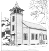 | February 10, 1992 (#92000024) | Road S-8-204 south of its junction with South Carolina Highway 45 33°25′33″N 80°01′39″W / 33.425833°N 80.0275°W / 33.425833; -80.0275 (Pineville Historic District) | Pineville | |
| 16 | Pinopolis Historic District North | Upload image | August 19, 1982 (#82003834) | Lake View St. south to Lake Moultrie 33°13′52″N 80°02′04″W / 33.231111°N 80.034444°W / 33.231111; -80.034444 (Pinopolis Historic District North) | Pinopolis | |
| 17 | Pinopolis Historic District South | Upload image | August 19, 1982 (#82003835) | County Road 5 33°13′52″N 80°02′04″W / 33.231111°N 80.034444°W / 33.231111; -80.034444 (Pinopolis Historic District South) | Pinopolis | |
| 18 | Pompion Hill Chapel |  | April 15, 1970 (#70000567) | 0.5 miles southwest of the junction of South Carolina Highways 41 and 402 33°05′00″N 79°50′17″W / 33.083333°N 79.838056°W / 33.083333; -79.838056 (Pompion Hill Chapel) | Huger | |
| 19 | Quinby Plantation House-Halidon Hill Plantation | Upload image | October 10, 1985 (#85003122) | 3 miles west of Huger 33°03′36″N 79°50′18″W / 33.06°N 79.838333°W / 33.06; -79.838333 (Quinby Plantation House-Halidon Hill Plantation) | Huger | |
| 20 | Richmond Plantation | Upload image | November 24, 1980 (#80003653) | Southeast of Cordesville 33°04′43″N 79°51′34″W / 33.078611°N 79.859444°W / 33.078611; -79.859444 (Richmond Plantation) | Cordesville | |
| 21 | William Robertson House |  | August 19, 1982 (#82003836) | County Road 5 33°13′52″N 80°02′14″W / 33.231111°N 80.037222°W / 33.231111; -80.037222 (William Robertson House) | Pinopolis | |
| 22 | St. James' Church, Goose Creek |  | April 15, 1970 (#70000566) | South of Goose Creek 32°58′31″N 80°01′47″W / 32.975278°N 80.029722°W / 32.975278; -80.029722 (St. James' Church, Goose Creek) | Goose Creek | |
| 23 | St. Stephen's Episcopal Church | 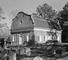 | April 15, 1970 (#70000570) | On South Carolina Highway 45 33°24′19″N 79°55′00″W / 33.4054°N 79.9166°W / 33.4054; -79.9166 (St. Stephen's Episcopal Church) | St. Stephen | |
| 24 | Santee Canal |  | May 5, 1982 (#82003833) | Northeast of Moncks Corner 33°21′00″N 80°03′38″W / 33.35°N 80.060556°W / 33.35; -80.060556 (Santee Canal) | Moncks Corner | |
| 25 | Strawberry Chapel and Childsbury Town Site | 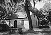 | April 26, 1972 (#72001194) | Southeast of Moncks Corner on County Road 44, north of the Tee of the Cooper River 33°05′33″N 79°54′12″W / 33.0925°N 79.903333°W / 33.0925; -79.903333 (Strawberry Chapel and Childsbury Town Site) | Moncks Corner | |
| 26 | Taveau Church | 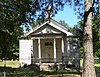 | February 14, 1978 (#78002493) | South of Cordesville on South Carolina Highway 44 33°06′21″N 79°56′23″W / 33.105833°N 79.939722°W / 33.105833; -79.939722 (Taveau Church) | Cordesville | |
| 27 | White Church |  | March 23, 1972 (#72001193) | 2 miles north of Cainhoy on County Road 98 32°57′37″N 79°51′29″W / 32.960278°N 79.858056°W / 32.960278; -79.858056 (White Church) | Cainhoy |
Former listings
| [3] | Name on the Register | Image | Date listed | Date removed | Location | City or town | Description |
|---|---|---|---|---|---|---|---|
| 1 | Calais Milestones | Upload image | March 14, 1973 (#73001677) | December 8, 2005 | On CR 98 and 44 | Cainhoy | [6] |
| 2 | Dean Hall |  | April 7, 1971 (#71001068) | October 7, 1971 | SE of Oakley | Oakley | Delisted after being relocated[7] |
See also
Wikimedia Commons has media related to National Register of Historic Places in Berkeley County, South Carolina.
- List of National Historic Landmarks in South Carolina
- National Register of Historic Places listings in South Carolina
References
- ^ The latitude and longitude information provided in this table was derived originally from the National Register Information System, which has been found to be fairly accurate for about 99% of listings. Some locations in this table may have been corrected to current GPS standards.
- ^ National Park Service, United States Department of the Interior, "National Register of Historic Places: Weekly List Actions", retrieved May 24, 2024.
- ^ a b Numbers represent an alphabetical ordering by significant words. Various colorings, defined here, differentiate National Historic Landmarks and historic districts from other NRHP buildings, structures, sites or objects.
- ^ "National Register Information System". National Register of Historic Places. National Park Service. March 13, 2009.
- ^ The eight-digit number below each date is the number assigned to each location in the National Register Information System database, which can be viewed by clicking the number.
- ^ South Carolina Department of Archives and History
- ^ South Carolina Department of Archives and History
- v
- t
- e

by county
- Abbeville
- Aiken
- Allendale
- Anderson
- Bamberg
- Barnwell
- Beaufort
- Berkeley
- Calhoun
- Charleston
- Cherokee
- Chester
- Chesterfield
- Clarendon
- Colleton
- Darlington
- Dillon
- Dorchester
- Edgefield
- Fairfield
- Florence
- Georgetown
- Greenville
- Greenwood
- Hampton
- Horry
- Jasper
- Kershaw
- Lancaster
- Laurens
- Lee
- Lexington
- Marion
- Marlboro
- McCormick
- Newberry
- Oconee
- Orangeburg
- Pickens
- Richland
- Saluda
- Spartanburg
- Sumter
- Union
- Williamsburg
- York
Municipalities and communities of Berkeley County, South Carolina, United States | ||
|---|---|---|
County seat: Moncks Corner | ||
| Cities |  | |
| Towns | ||
| CDPs | ||
| Other communities | ||
| Footnotes | ‡This populated place also has portions in an adjacent county or counties | |
| ||


