Nagyiván
Village in Jász-Nagykun-Szolnok, Hungary

Coat of arms
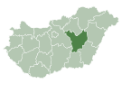
 Hungary
 (2015)
5363
Nagyiván is a village in Jász-Nagykun-Szolnok county, in the Northern Great Plain region of central Hungary.
Geography
It covers an area of 43.16 km2 (17 sq mi) and has a population of 1,175 people (2015).[1] It is one of the driest area in Hungary. The annual precipitation is about 520 mm. The village lies at the edge of the Hortobágy National Park (the first and biggest Hungarian national park, part of the world heritage). The inhabitants mainly work in the agricultural sector.
References
- ^ a b Gazetteer of Hungary, 1st January 2015. Hungarian Central Statistical Office. 3 September 2015
External links
- Official site in Hungarian
- v
- t
- e
- Tiszafüred (district seat)

- Nagyiván
- Tiszaderzs
- Tiszaigar
- Tiszaörs
- Tiszaszentimre
- Tiszaszőlős
| ||
|---|---|---|
| City with county rights |
|   |
| Towns | ||
| Large villages | ||
| Villages |
| |
| Other topics |
| |
 | This Jász-Nagykun-Szolnok location article is a stub. You can help Wikipedia by expanding it. |
- v
- t
- e


