Mount Sacagawea
Mountain in Wyoming, United States


Mount Sacagawea
Location in Wyoming
Show map of Wyoming
Mount Sacagawea
Location in the United States
Show map of the United StatesMount Sacagawea (13,575 ft (4,138 m)) is the eighth-highest peak in the U.S. state of Wyoming and the seventh-highest in the Wind River Range.[4][5] It was named after Sacagawea, the young Lemhi Shoshone woman who accompanied the Lewis and Clark Expedition as an interpreter and guide. The Upper Fremont Glacier is located southeast and the Sacagawea Glacier is northeast of the mountain.[6] Straddling the Continental Divide, Mount Sacagawea is one mile (1.6 km) northwest of Fremont Peak.
Hazards
Encountering bears is a concern in the Wind River Range.[7] There are other concerns as well, including bugs, wildfires, adverse snow conditions and nighttime cold temperatures.[8]
Importantly, there have been notable incidents, including accidental deaths, due to falls from steep cliffs (a misstep could be fatal in this class 4/5 terrain) and due to falling rocks, over the years, including 1993,[9] 2007 (involving an experienced NOLS leader),[10] 2015[11] and 2018.[12] Other incidents include a seriously injured backpacker being airlifted near SquareTop Mountain[13] in 2005,[14] and a fatal hiker incident (from an apparent accidental fall) in 2006 that involved state search and rescue.[15] The U.S. Forest Service does not offer updated aggregated records on the official number of fatalities in the Wind River Range.
Gallery
-
 Southwest aspect
 -
 Mount Sacagawea (left) and Fremont Peak (right of center)
 -
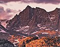 Southwest aspect at sunset


References
- ^ a b c "Mount Sacagawea, Wyoming". Peakbagger.com. Retrieved May 24, 2013.
- ^ "Mount Sacagawea". Geographic Names Information System. United States Geological Survey, United States Department of the Interior. Retrieved May 24, 2013.
- ^ Joe Kelsey, 2013, Climbing and Hiking in the Wind River Mountains, Falcon Guides, ISBN 9781493001354, page 33.
- ^ "Wind River Range". Peakbagger.com. Retrieved May 24, 2013.
- ^ "Wyoming 13,000-foot Peaks". Peakbagger.com. Retrieved May 24, 2013.
- ^ Fremont Peak North, WY (Map). TopoQwest (United States Geological Survey Maps). Retrieved May 24, 2013.
- ^ Staff (April 24, 2017). "Bear Safety in Wyoming's Wind River Country". WindRiver.org. Archived from the original on July 26, 2021. Retrieved May 31, 2022.
- ^ Ballou, Dawn (July 27, 2005). "Wind River Range condition update - Fires, trails, bears, Continental Divide". PineDaleOnline News. Archived from the original on April 21, 2021. Retrieved May 31, 2022.
- ^ Staff (1993). "Falling Rock, Loose Rock, Failure to Test Holds, Wyoming, Wind River Range, Seneca Lake". American Alpine Club. Archived from the original on July 26, 2021. Retrieved May 31, 2022.
- ^ MacDonald, Dougald (August 14, 2007). "Trundled Rock Kills NOLS Leader". Climbing. Archived from the original on July 26, 2021. Retrieved May 31, 2022.
- ^ Staff (December 9, 2015). "Officials rule Wind River Range climbing deaths accidental". Casper Star-Tribune. Archived from the original on July 26, 2021. Retrieved May 31, 2022.
- ^ Dayton, Kelsey (August 24, 2018). "Deadly underestimation". WyoFile News. Archived from the original on July 26, 2021. Retrieved May 31, 2022.
- ^ Funk, Jason (2009). "Squaretop Mountain Rock Climbing". Mountain Project. Archived from the original on July 26, 2021. Retrieved May 31, 2022.
- ^ Staff (July 22, 2005). "Injured man rescued from Square Top Mtn - Tip-Top Search & Rescue helps 2 injured on the mountain". PineDaleOnline News. Archived from the original on July 26, 2021. Retrieved May 31, 2022.
- ^ Staff (September 1, 2006). "Incident Reports - September, 2006 - Wind River Search". WildernessDoc.com. Archived from the original on January 27, 2020. Retrieved May 31, 2022.
External links
Wikimedia Commons has media related to Wind River Range.
- General Information on the Wind River Range Archived 2011-04-14 at the Wayback Machine
- Climbing the Wind River Range (more)
- Glaciers in the Wind River Range
- Shoshone National Forest Federal website
- Continental Divide Trail information
- v
- t
- e
- Abiathar Peak
- Atkins Peak
- Barronette Peak
- Breccia Peak
- Clayton Mountain
- Colter Peak
- Druid Peak
- Eagle Peak
- Fortress Mountain
- Francs Peak
- Index Peak
- Mount Chittenden
- First Peoples Mountain
- Mount Hornaday
- Mount Langford
- Mount Norris
- Mount Schurz
- Mount Stevenson
- Pilot Peak
- Sheep Mesa
- The Thunderer
- Washakie Needles
- Younts Peak
| Bear Lodge Mountains | |
|---|---|
| Others |
- Antler Peak
- Bannock Peak
- Bunsen Peak
- Clagett Butte
- Dome Mountain (Park County)
- Echo Peak
- Gray Peak
- Joseph Peak
- Mount Everts
- Mount Haynes
- Mount Holmes
- Mount Jackson
- Purple Mountain
- Quadrant Mountain
- Sepulcher Mountain
- Terrace Mountain
- Three Rivers Peak
- Trilobite Point
- White Peaks
- Darwin Peak
- Doubletop Peak
- Sheep Mountain
- Elk Mountain (Carbon County)
- Medicine Bow Peak
- Albright Peak
- Battleship Mountain
- Bivouac Peak
- Buck Mountain
- Cathedral Group
- Cleaver Peak
- Cloudveil Dome
- Disappointment Peak
- Doane Peak
- Dry Ridge Mountain
- Eagles Rest Peak
- Elk Mountain (Teton County)
- Forellen Peak
- Fossil Mountain
- Grand Teton
- Green Lakes Mountain
- Housetop Mountain
- The Jaw
- Littles Peak
- Maidenform Peak
- Middle Teton
- Moose Mountain
- Mount Bannon
- Mount Glory
- Mount Hunt
- Mount Jedediah Smith
- Mount Meek
- Mount Moran
- Mount Owen
- Mount Saint John
- Mount Wister
- Mount Woodring
- Mount Woodrow Wilson
- Nez Perce Peak
- Owl Peak
- Prospectors Mountain
- Rammell Mountain
- Ranger Peak
- Raynolds Peak
- Red Mountain
- Rendezvous Mountain
- Rendezvous Peak
- Rock of Ages
- Rockchuck Peak
- Rolling Thunder Mountain
- Shadow Peak
- South Teton
- Spearhead Peak
- Static Peak
- Survey Peak
- Symmetry Spire
- Table Mountain
- Teepe Pillar
- Teewinot Mountain
- Temple Peak
- Thor Peak
- Traverse Peak
- Veiled Peak
- The Wall
- Window Peak
- American Legion Peak
- Atlantic Peak
- Bair Peak
- Bastion Peak
- Bastion Peak-Northeast Peak
- Bears Ears Mountain
- Big Sandy Mountain
- Block Tower
- Bow Mountain
- Brown Cliffs North
- Cathedral Peak
- Desolation Peak
- Dog Tooth Peak
- Dome Mountain (Hot Springs County)
- Doublet Peak
- Downs Mountain
- East Temple Peak
- Flagstone Peak (Fremont County)
- Fremont Peak
- Gannett Peak
- Harrower Peak
- Henderson Peak
- Jackson Peak
- Klondike Peak
- Knife Point Mountain
- Lander Peak
- Lizard Head Peak
- Mitchell Peak
- Mount Bonneville
- Mount Chauvenet
- Mount Febbas
- Mount Helen
- Mount Hooker
- Mount Koven
- Mount Lander
- Mount Nystrom
- Mount Owen
- Mount Sacagawea
- Mount Warren
- Mount Washakie
- Mount Whitecap
- Overhanging Tower
- Payson Peak
- Pingora Peak
- Pylon Peak
- Raid Peak
- Rampart Peak
- Roaring Fork Mountain
- Shale Mountain
- Sharks Nose
- South Downs Mountain
- The Sphinx
- Split Mountain
- Sunbeam Peak
- Three Waters Mountain
- Torrey Peak
- Turret Peak
- Twin Peaks
- Union Peak
- Valentine Mountain
- Valentine Peak
- War Bonnet Peak
- Warrior Peaks
- Watch Tower
- Whiskey Mountain
- Wind River Peak
- Wolfs Head
- Amethyst Mountain
- Aspen Mountain
- Barlow Peak
- Bridger Mountains
- Cook Peak
- Copper Mountain
- Dirty Mountain
- Douglas Knob
- Dunraven Peak
- Factory Hill
- Ferris Mountains
- Folsom Peak
- Garfield Peak
- Granite Mountains
- Granite Peak
- Heart Mountain
- Hedges Peak
- Hoyt Peak
- Jelm Mountain
- Mansface Hill
- Mount Hancock
- Mount Leidy
- Mount Sheridan
- Mount Washburn
- National Park Mountain
- Owl Creek Mountains
- Prospect Peak (Park County)
- Rawhide Buttes
- Roaring Mountain
- Sierra Madre Range
- Signal Mountain
- Snake River Range
- Specimen Ridge
- Sublette Mountain
- Tongue Butte
- Trischman Knob
- White Mountain
- Wilkins Peak

Portals:
 Geography
 Geology
 Mountains


 | This article about a location in Wyoming is a stub. You can help Wikipedia by expanding it. |
- v
- t
- e


