Mount Mahler
Mountain in the American state of Colorado


Mount Mahler
Location in Colorado
Show map of Colorado
Mount Mahler
Mount Mahler (the United States)
Show map of the United StatesNever Summer Mountains
Mount Mahler is a 12,497-foot-elevation (3,809-meter) mountain summit in Jackson County, Colorado, United States.
Description
Mount Mahler is the eighth-highest peak of the Never Summer Mountains which are a subrange of the Rocky Mountains.[6] The mountain is situated on the northern boundary of the Never Summer Wilderness, on land managed by Routt National Forest.[1] Precipitation runoff from the mountain's slopes drains into tributaries of the Michigan River. Topographic relief is significant as the summit rises 2,250 feet (690 meters) above Silver Creek in one mile (1.6 km) and 1,830 feet (560 meters) above Lake Agnes in 0.6 mile (0.97 km).
Etymology
The mountain's toponym was officially adopted on October 18, 2006, by the United States Board on Geographic Names to honor Gustav Mahler (1860–1911), Austro-Bohemian Romantic composer and conductor.[1]
Climate
According to the Köppen climate classification system, Mount Mahler is located in an alpine subarctic climate zone with cold, snowy winters, and cool to warm summers.[7] Due to its altitude, it receives precipitation all year, as snow in winter, and as thunderstorms in summer, with a dry period in late spring.
See also
- Mountains of Jackson County, Colorado
 Mountains portal

Gallery
-
 Nokhu Crags (left) and Mt. Mahler (right of center)
 -
 Mt. Mahler (center) and Braddock Peak (right)
 -
 The northern group of the Never Summer Mountains.
Left to rightː Nokhu Crags, Mt. Richthofen, Mt. Mahler, Braddock Peak -
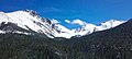
 North aspect of Mahler, from Lake Agnes
 -
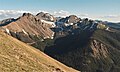 The northern group of the Never Summer Mountains viewed from Diamond Peaks. Left to rightː Nokhu Crags, Mt. Richthofen, Mt. Mahler, Braddock Peak


References
- ^ a b c d "Mount Mahler". Geographic Names Information System. United States Geological Survey, United States Department of the Interior. Retrieved May 7, 2023.
- ^ a b c "Mahler, Mount - 12,491' CO". listsofjohn.com. Retrieved 2023-05-07.
- ^ "Mount Mahler, Colorado". Peakbagger.com. Retrieved May 7, 2023.
- ^ a b Geologic map of the Mount Richthofen quadrangle and the western part of the Fall River Pass quadrangle, Grand and Jackson Counties, Colorado, J.M. O'Neill, U.S. Geological Survey, 1981.
- ^ Jon Kedrowski (2022), Classic Colorado Hikes, Colorado Mountain Club, ISBN 9781937052836
- ^ "Mount Mahler, Peakvisor.com". Retrieved May 7, 2023.
- ^ Peel, M. C.; Finlayson, B. L.; McMahon, T. A. (2007). "Updated world map of the Köppen−Geiger climate classification". Hydrol. Earth Syst. Sci. 11. ISSN 1027-5606.
External links
- Weather forecast: Mount Mahler
Places adjacent to Mount Mahler | ||||||||||||||||
|---|---|---|---|---|---|---|---|---|---|---|---|---|---|---|---|---|
| ||||||||||||||||


- v
- t
- e

- Mount Garfield
- Aspen Mountain
- Capitol Peak
- Castle Peak
- Cathedral Peak
- Chair Mountain
- Crested Butte
- Gothic Mountain
- Italian Mountain
- Maroon Bells
- Mount Emmons
- Mount Owen
- Mount Sopris
- Pyramid Peak
- Snowmass Mountain
- Snowmass Peak
- Treasure Mountain
- Black Mountain (Moffat County)
- Columbus Mountain
- Elk Mountain (Routt County)
- Hahns Peak
- Flat Top Mountain
- Sleepy Cat Peak
- Eagles Nest
- Jacque Peak
- Meridian Peak
- Mount Powell
- The Spider
- Crater Peak
- North Mamm Peak
- Clark Peak
- Arkansas Hills
- Clinton Peak
- Dyer Mountain
- Gemini Peak
- Horseshoe Mountain
- Mount Arkansas
- Mount Bross
- Mount Buckskin
- Mount Democrat
- Mount Lincoln
- Mount Sheridan
- Mount Sherman
- Pacific Peak
- West Buffalo Peak
- Elk Mountain (Grand County)
- Parkview Mountain
- Radial Mountain
- Whiteley Peak
| Sangre de Cristo Range |
|
|---|---|
| Wet Mountains |
|
| Others |
|
| Collegiate Peaks |
|
|---|---|
| Others |
|
- Crystal Peak
- Fletcher Mountain
- Peak 10
- Peak One
- Quandary Peak
- Tenmile Peak
- Bear Mountain
- Blair Mountain
- Chalk Mountains
- Cochetopa Hills
- Dawson Butte
- Diamond Peak
- Flirtation Peak
- Granite Peak
- Grand Hogback
- Grannys Nipple
- Horsefly Peak
- Lead Mountain (Grand County)
- Mount Neva
- Powell Peak
- San Luis Hills
- Storm King Mountain
- Terrible Mountain
- Two Buttes
- Ute Mountain


