Mosquera, Cundinamarca
Municipality and city in Cundinamarca, Colombia

Flag

Seal
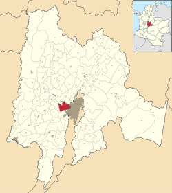
Location of the municipality and town of Mosquera in the Cundinamarca Department of Colombia
 Colombia
 Cundinamarca
(2016-2019)
(2018 census)[1]
Mosquera is a municipality of Colombia in the Western Savanna Province, part of the department of Cundinamarca. Mosquera is close to the capital Bogotá and is part of its metropolitan area. The urban centre of Mosquera is situated at an altitude of 2,516 metres (8,255 ft) on the Bogotá savanna. The municipality borders the localities Bosa and Fontibón of Bogotá in the east, Soacha in the south, Madrid and Funza in the north and Bojacá in the west.[2]
Etymology
Mosquera is named after its founder, former president of Colombia Tomás Cipriano de Mosquera, who in 1861 separated Mosquera from Funza.[2]
History
Mosquera is close to Lake Herrera, a remnant lake of the large Pleistocene Lake Humboldt that existed on the Bogotá savanna until approximately 30,000 years BP. The archaeological findings around Lake Herrera date to the preceramic period, predating the Herrera Period, named after the lake.
The Muisca established their civilisation typically as of 800 AD. They were an advanced culture and performed agriculture on the high plains of the savanna. In the Muisca times maize, potatoes, arracacha, quinoa, sweet potatoes, yuca, peppers, tomatoes, beans and pumpkins were cultivated in Mosquera. The Muisca were predominantly farmers and traders and their economy was based on the extraction of salt from the northern parts of the Bogotá savanna. Fruits and other agricultural products growing in different climates were traded on the frequent markets of the Muisca. In Mosquera pineapples, avocadoes, guanabanas, ice-cream beans, pitahayas and guayabas were the fruits traded with warmer climates. Tobacco also came from more tropical regions while cotton was traded with the colder climate Lache.[2]
Funza, of which Mosquera formed the southern part until 1861, was founded by conquistador Gonzalo Jiménez de Quesada who arrived in the region on April 20, 1537.
Presently, Mosquera is a satellite town of the capital Bogotá and has grown significantly in recent years.[2]
In 2022, an unusual type of white foam covered the town. Residents reported that it produced an awful smell and that it had covered large parts of the municipality. While many locals were forced to get inhalers no effects on public health were recorded.[3]
Climate
Mosquera has a subtropical highland climate (Köppen Cfb) with cool temperatures throughout the year.
| Climate data for Mosquera (Tibaitatá Research Center) (1991–2020) | |||||||||||||
|---|---|---|---|---|---|---|---|---|---|---|---|---|---|
| Month | Jan | Feb | Mar | Apr | May | Jun | Jul | Aug | Sep | Oct | Nov | Dec | Year |
| Mean daily maximum °C (°F) | 20.46 (68.83) | 20.63 (69.13) | 20.28 (68.50) | 19.88 (67.78) | 19.68 (67.42) | 19.32 (66.78) | 19.03 (66.25) | 19.31 (66.76) | 19.84 (67.71) | 19.88 (67.78) | 19.74 (67.53) | 20.11 (68.20) | 19.85 (67.73) |
| Daily mean °C (°F) | 12.98 (55.36) | 13.48 (56.26) | 13.64 (56.55) | 13.86 (56.95) | 13.95 (57.11) | 13.67 (56.61) | 13.37 (56.07) | 13.34 (56.01) | 13.31 (55.96) | 13.38 (56.08) | 13.42 (56.16) | 13.22 (55.80) | 13.47 (56.25) |
| Mean daily minimum °C (°F) | 4.95 (40.91) | 6.05 (42.89) | 7.35 (45.23) | 8.53 (47.35) | 8.54 (47.37) | 7.91 (46.24) | 7.37 (45.27) | 6.99 (44.58) | 6.33 (43.39) | 7.13 (44.83) | 7.62 (45.72) | 6.12 (43.02) | 7.07 (44.73) |
| Average precipitation mm (inches) | 21.58 (0.85) | 35.44 (1.40) | 68.89 (2.71) | 89.7 (3.53) | 94.9 (3.74) | 58.69 (2.31) | 46.17 (1.82) | 37.7 (1.48) | 44.69 (1.76) | 76.61 (3.02) | 87.42 (3.44) | 42.56 (1.68) | 704.36 (27.73) |
| Average precipitation days (≥ 1.0 mm) | 4.01 | 6.24 | 10.07 | 12.39 | 13.75 | 10.36 | 9.56 | 8.49 | 7.72 | 11.24 | 11.81 | 6.73 | 112.36 |
| Source: NOAA[4] | |||||||||||||
Born in Mosquera
- Olimpo López (1918–2015), pastry chef and creator of the Chocoramo (Productos Ramo)[5]
Gallery
-
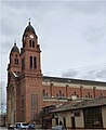 Church of Mosquera
 -
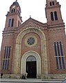 Church
 -
 Bustes of Tomás Cipriano de Mosquera and Simón Bolívar
 -
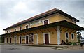
 Train station
 -
 Cultural centre


References
- ^ Citypopulation.de Population of Mosquera Municipality with localities
- ^ a b c d (in Spanish) Official website Mosquera Archived 2015-12-20 at the Wayback Machine
- ^ "Foul-smelling foam clogs up Colombian town of Mosquera". BBC News. 2022-04-29. Retrieved 2022-04-29.
- ^ "World Meteorological Organization Climate Normals for 1991-2020 — Mosquera". National Oceanic and Atmospheric Administration. Retrieved January 26, 2024.
- ^ "A los 97 años muere Olimpo López, creador del chocorramo". El País (Cali). 2015-10-16. Retrieved 2015-11-14.
Wikimedia Commons has media related to Mosquera, Cundinamarca.
- v
- t
- e

- Bojacá
- El Rosal
- Facatativá
- Funza
- Madrid
- Mosquera
- Subachoque
- Zipacón
Authority control databases | |
|---|---|
| International |
|
| National |
|
04°42′28″N 74°13′58″W / 4.70778°N 74.23278°W / 4.70778; -74.23278
ToC
Trending
Recent Change


