Monserrat, Buenos Aires
Barrio in Buenos Aires, Argentina
Emblem[1]

Location of Montserrat within Buenos Aires
City Legislature
Buenos Aires Cabildo
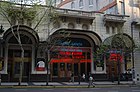
Café Tortoni
Casa Rosada
Colegio Nacional de Buenos Aires
Jesuit Temple of St. Ignatius and college
Plaza de Mayo
Equestrian monument to General Manuel Belgrano
Monserrat[2] or Montserrat[3][b] (pronounced [monseˈrat]) is a neighbourhood in the east of the Buenos Aires CBD. The district features some of the most important public buildings in Buenos Aires, including city hall, the city legislature, Casa Rosada, the Colegio Nacional de Buenos Aires and the Libertador Building (Ministry of Defense), among others.


Avenida de Mayo runs through the Monserrat district, connecting Plaza de Mayo and the Plaza de los Dos Congresos (Congressional Plaza).
A block, or two, south of the Plaza de Mayo, the older section of Monserrat begins. This is Buenos Aires' oldest neighborhood and even today, very little of the cityscape there is less than a hundred years old (except along Belgrano Avenue), thereby making a nearly seamless transition to the likewise historic San Telmo district, to the south.
History
The Monserrat area traces its origins to the foundation of Buenos Aires itself, when, in 1580, Spanish Adelantado Juan de Garay disembarked on the area's shores. The Fort of Juan Baltazar of Austria, the marginal settlement's first, was built in 1594 and, in 1608, newly arrived Jesuits were granted a 2-hectare (5 acre) lot, nearby. The Jesuits began work on the Saint Ignatius Church in 1686. Consecrated in 1734, it is the oldest existing church in Buenos Aires. Possessing the finest school and library at the time and offering colonial Buenos Aires' only truly classical education there, their property became popularly known as the "Illuminated Block." The small city's growing population led to the introduction of a number of other religious orders in this area, notably the Catalan Brotherhood of the Virgin of Montserrat, whose chapel became the neighborhood namesake in 1769. The Cabildo (City hall) became the scene of the 1810 pronouncements in favor of autonomy that later led to independence and, to commemorate the fact, in 1811 the iconic May Pyramid was placed in what later became the Plaza de Mayo.
Little changed over the next seventy years, Monserrat's muddy shore and typically colonial grid of cobblestone streets came under a rapid modernization following Argentina's sudden economic development after 1875. Land reclamation and the creation of docks parallel to the area led to the construction of Paseo Colón (still a major thoroughfare) along Monserrat's eastern edge. The area's two adjoining squares became the Plaza de Mayo in 1884, a milestone joined by the completion of the presidential executive building, the Casa Rosada. This was followed by the massive razing of colonial architecture (including part of the Cabildo) to make way for the Avenida de Mayo, opened in 1894 and Congressional Plaza, in 1910. The avenue became home to the Buenos Aires Metro's first stations, in 1913.
The area's led central location and its presence therein of much of Argentina's governmental structure led to monumental construction over the next twenty years, notable among which are the Buenos Aires City Legislature, the Customs building, the offices of La Prensa (today the Buenos Aires House of Culture), the art-deco NH City Hotel (off the Plaza de Mayo), the Ministry of Defense and South Diagonal Avenue. Monserrat's western half was partitioned from the rest by the southward expansion of the massive Nueve de Julio Avenue around 1950 and, partial to trendy high-rises, much of Monserrat's middle class and commercial office space market left, afterwards. The area became a largely bohemian quarter popular with tango performers and artists, as well as many who preferred the area's close proximity to the growing financial district to the north and its relatively low rent scale. Its rich architectural history and quaint, narrow streets have, as in neighboring San Telmo, helped lead to renewed interest in Monserrat since around 1990, a change highlighted by the 1993 opening of the high-rise InterContinental Hotel. The area's numerous Spanish restaurants and social clubs belonging to Buenos Aires' large Spaniard community have long associated Monserrat with local Spanish tradition, helping make it attractive to tourism for cultural reasons, as well as those of ambiance.
Among its historic buildings is the house where Viceroy Santiago Liniers lived. This historical site is known by the name of Casa de Liniers, and is located on the street Venezuela 469.[4] Another of the historical sites is the Iglesia Presbiteriana San Andrés, a Presbyterian church located on Belgrano Avenue.[5]
Gallery
-
 Vintage entrance to subte Line A of the Buenos Aires Metro on Avenida de Mayo; behind it, City Hall
 -
 Architectural contrasts on the Avenida de Mayo
 -
 Typical vintage corner in Monserrat
 -
 Eastward view of the Plaza de Mayo and Casa Rosada
 -
 The Jesuit Temple of St. Ignatius and the colonial Illuminated Block
 -
 The Ministry of Defense, the Libertador Building
 -
 City Historical Museum
 -
 Tomb of Argentine patriot Manuel Belgrano at the Santo Domingo Convent
 -

-
 Corner of South Diagonal and Belgrano Avenues
 -
 Monument to Mariano Moreno
 -
 Otto Wulff Building, Belgrano Avenue
 -
 Corner of Florida Street and Rivadavia Avenue
 -
 Buenos Aires Police Headquarters
 -


Notes
References
- ^ "The emblems of the 48 barrios of Buenos Aires were presented" (Spanish) by ámbito.com August 29, 2011
- ^ "Map of Monserrat – City Government of Buenos Aires".
- ^ "Montserrat". Buenos Aires Ciudad - Gobierno de la Ciudad Autónoma de Buenos Aires (in Spanish). Retrieved 2020-04-12.
- ^ Venezuela 469 (Casa del Virrey Liniers). Centro de Arqueología Urbana. 22 April 2014.
- ^ Mil y una curiosidades de Buenos Aires. Diego Zigiotto. 18 September 2018. ISBN 9789876279697.
External links
 Argentina portal

- Map of Monserrat (in Spanish)
- v
- t
- e
Landmarks of Buenos Aires City
historic buildings
and structures
- Cabildo
- Casa Rosada
- Chacarita Cemetery
- City Hall
- City Legislature
- Confitería del Molino
- Congress Palace
- Customs House
- CCK
- Duhau Palace
- Estrugamou Building
- Floralis Genérica
- Galerías Pacífico
- Immigrants' Hotel
- Kavanagh Building
- Libertador Building
- May Pyramid
- Metropolitan Cathedral
- Ministry of Public Works Building
- Monument to Giuseppe Garibaldi
- Obelisco
- Palacio de Aguas Corrientes
- Palacio Barolo
- Palacio Haedo
- Pizzurno Palace
- Plaza Hotel
- Recoleta Cemetery
- San Martín Palace
- Santo Domingo convent
- Sarmiento Frigate
- Torre Monumental
- Uruguay Corvette
- Women's Bridge
neighbourhoods
- Avellaneda Park
- Botanical Gardens
- Buenos Aires Eco-Park
- Buenos Aires Ecological Reserve
- Chacabuco Park
- Ciudad Universitaria
- Congressional Plaza
- Japanese Gardens
- Lezama Park
- Palermo Gardens
- Parque Centenario
- Parque de la Memoria
- Plaza Canadá
- Plaza Fuerza Aérea Argentina
- Plaza de la República
- Plaza de Mayo
- Plaza Intendente Alvear
- Plaza San Martín
Institutions
- Ateneo Bookshop
- Argentine Automobile Club
- Café Tortoni
- Cine Cosmos
- Foreign Debt Museum
- Fortabat Art Collection
- House of Culture
- Illuminated Block
- Isaac Fernández Blanco Museum
- King Fahd Cultural Center
- Latin American Art Museum
- Modern Art Museum
- Natural Sciences Museum
- National Library
- National Museum of Decorative Arts
- National Museum of Fine Arts
- National Museum of History
- Opera House
- Paz Palace
- Planetarium
- Recoleta Cultural Center
- Rojas Cultural Center
- San Martín Cultural Center
- San Martín National Institute
- Sarmiento Museum
- Eduardo Sívori Museum
- Fundacion Proa
- Argentinos Juniors Stadium
- Boca Juniors Stadium
- CeNARD
- Ferro C. Oeste Stadium
- GEBA Stadium
- Hippodrome of Palermo
- Huracán Stadium
- Lawn Tennis Club
- Luna Park Arena
- Malvinas Argentinas Arena
- Mary Terán de Weiss Tennis Stadium
- Nueva Chicago Stadium
- Obras Sanitarias Arena
- Polo Stadium
- Race Circuit
- River Plate Stadium
- San Lorenzo Stadium
- José Amalfitani Stadium
entertainment
and avenues
- Avenida 9 de Julio
- Avenida Alvear
- Avenida de Mayo
- Avenida del Libertador
- Belgrano Avenue
- Callao Avenue
- Caminito
- Córdoba Avenue
- Coronel Díaz Street
- Corrientes Avenue
- Figueroa Alcorta Avenue
- Florida Street
- General Paz Avenue
- President Julio Argentino Roca Avenue
- Leandro Alem Avenue
- Pueyrredón Avenue
- President Roque Sáenz Peña Avenue
- Rivadavia Avenue
- Santa Fe Avenue
- Sarmiento Avenue
- Scalabrini Ortiz Avenue

34°36′45″S 58°23′00″W / 34.61250°S 58.38333°W / -34.61250; -58.38333


