Merksplas
Municipality in Flemish Community, Belgium

Flag

Coat of arms
Location of Merksplas


Merksplas
Location in Belgium 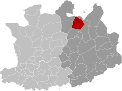
Location of Merksplas in the province of Antwerp

 Belgium
 (2020-01-01)[1]
2330
13023
Merksplas (Dutch pronunciation: [ˈmɛr(ə)ksplɑs]) is a municipality located in the Belgian province of Antwerp. The municipality comprises only the town of Merksplas proper. In 2021, Merksplas had a total population of 8,616.[2] The total area is 44.56 km2.
References
External links
 Media related to Merksplas at Wikimedia Commons
- Official website - Available only in Dutch
Places adjacent to Merksplas | |
|---|---|


Authority control databases | |
|---|---|
| International |
|
| Geographic |
|
 | This Antwerp Province location article is a stub. You can help Wikipedia by expanding it. |
- v
- t
- e


