Medinipur division
Division in West Bengal, India
Medinipur | |
|---|---|
 Location of Medinipur in West Bengal | |
 Interactive Map Outlining Medinipur | |
| Country |  India India |
| State |  West Bengal West Bengal |
| Established | 2002 |
| Capital | Medinipur |
| Districts | Bankura, Jhargram, Paschim Medinipur, Purba Medinipur, Purulia |
| Area | |
| • Total | 27,223 km2 (10,511 sq mi) |
| Population (2011) | |
| • Total | 18,672,669 |
| • Density | 690/km2 (1,800/sq mi) |
Medinipur Division is one of the 5 divisions in the Indian state of West Bengal. It is the westernmost division of West Bengal. Earlier it was a part of Burdwan division and was curved out from it in 2016.[1] The port city of Haldia is located in this division
Districts
It consists of 5 districts:[2]
| Code | District | Headquarters | Established | Sub-Division | Area | Population As of 2011 | Population Density | Map |
|---|---|---|---|---|---|---|---|---|
| ME | Purba Medinipur | Tamluk | 2002[3] | 4,736 km2 (1,829 sq mi) | 5,094,238 | 1,076/km2 (2,790/sq mi) |  | |
| ME | Paschim Medinipur | Medinipur | 2002[3] | 6,308 km2 (2,436 sq mi) | 5,943,300 | 636/km2 (1,650/sq mi) |  | |
| PU | Purulia | Purulia | 1956 | 6,259 km2 (2,417 sq mi) | 2,927,965 | 468/km2 (1,210/sq mi) |  | |
| BN | Bankura | Bankura | 1947 | 6,882 km2 (2,657 sq mi) | 3,596,292 | 523/km2 (1,350/sq mi) | 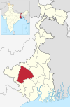 | |
| JH | Jhargram | Jhargram | 2017[5] | 3,037.64 km2 (1,172.84 sq mi) | 1,136,548 | 374/km2 (970/sq mi) |  | |
| Total | 5 | — | - | 15 | 27,223 km2 (10,511 sq mi) | 18,672,669 | 686/km2 (1,780/sq mi) | 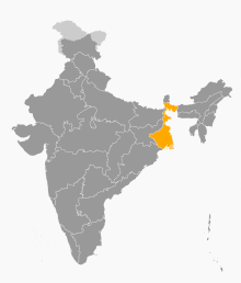 |
Demographics
Hindus form the majority of the population of Medinipur division and comprises 82.3% of the population. There is a significant population of various tribes in this division such as Kudmi ,Santhal, Munda, etc. Muslims comprises 10.1% of the population.[6]
References
- ^ "Bengal to be divided into two more administrative divisions". 23 November 2016.
- ^ "Directory of District, Sub division, Panchayat Samiti/ Block and Gram Panchayats in West Bengal, March 2008". West Bengal. National Informatics Centre, India. 19 March 2008. p. 1. Archived from the original on 25 February 2009. Retrieved 2009-02-28.
- ^ a b Jana, Naresh (31 December 2001). "Tamluk readies for giant's partition". The Telegraph (Kolkata). Archived from the original on 14 March 2014. Retrieved 1 September 2008.
- ^ http://aitcofficial.org/aitc/bengal-chief-minister-sub-division-purulia-manbazar-jhalda/
- ^ "Brief History of Cooch Behar". Official website of Cooch Behar District. Archived from the original on 24 July 2011. Retrieved 10 September 2008.
- ^ Population by religious community: West Bengal. 2011 Census of India.
- v
- t
- e
State of West Bengal
- Gauda Kingdom
- Pala Empire
- Sena dynasty
- Mallabhum kingdom
- Cooch Behar State
- Sher Shah Suri
- Mughal Empire
- Nawabs of Bengal
- East India Company
- Battle of Plassey
- Bengal Presidency
- Great Bengal famine of 1770
- Indian Rebellion of 1857
- Bengal Renaissance
- Bardhaman Raj
- Nadia Raj
- Jhargram Raj
- Sovabazar Raj
- Partition of Bengal (1905)
- Revolutionary movement for Indian independence
- Anushilan Samiti
- Jugantar
- Bengal famine of 1943
- Direct Action Day
- Noakhali riots
- Partition of Bengal (1947)
- Bengali Language Movement (Manbhum)
- Bangladesh Liberation War
- Naxalite–Maoist insurgency
- Chief Ministers
- Governor
- Legislative Assembly
- Human Rights Commission
- Political parties (All India Trinamool Congress
- Communist Party (Marxist)
- Indian National Congress
- Bharatiya Janata Party)
- Parliamentary constituencies
- Assembly constituencies
- CID West Bengal
- Kolkata Police
districts
| Burdwan division | |
|---|---|
| Jalpaiguri division | |
| Malda division |
|
| Medinipur division |
|
| Presidency division |
|
towns
- Alipore
- Asansol
- Berhampore
- Balurghat
- Bankura
- Barasat
- Bardhaman
- Bishnupur
- Hugli-Chuchura
- Cooch Behar
- Darjeeling
- Durgapur
- Haldia
- Howrah
- Jalpaiguri
- Jaynagar Majilpur
- Jiaganj Azimganj
- Kalimpong
- Kharagpur
- Kolkata
- Krishnanagar
- Kurseong
- Malda
- Midnapore
- Murshidabad
- Purulia
- Raiganj
- Siliguri
- Siuri
- Tamluk
- List of cities in West Bengal by population
- Cities and towns by district
- Bengal Renaissance
- Bengali calendars
- Patachitra
- Chalchitra
- Arts of West Bengal
- Baul
- Bhadu
- Gombhira
- Chhau dance
- Cuisine
- Rabindra Sangeet
- Rabindra Nritya Natya
- Holi
- Prostitution in Kolkata
- Pohela Boishakh
- Durga Puja
- Bhai Dooj
- Raksha Bandhan
- Ratha Yatra
- Architecture of Bengal
- Bengali language
- Bengali literature
- Feluda
- Lalmohan Ganguly
- Professor Shonku
- Tarini Khuro
- Kakababu
- Kiriti Roy
- Pather Panchali (novel)
- Tollywood (Bengali cinema)
- Jatra
- Ghosts in Bengali culture
- Baluchari sari
- Banglar Rosogolla
- Bankura horse
- Bengal Patachitra
- Chhau mask
- Darjeeling tea
- Dhaniakhali Sari
- Dhokra
- Fazli (mango)
- Garad Saree
- Gobindobhog
- Himsagar
- Jaynagarer Moa
- Madurkathi
- Manasa chali
- Mihidana
- Nakshi kantha
- Santiniketan Leather Goods
- Shantipuri sari
- Sitabhog
- Sundarban Honey
- Tangail Saree
- Tulaipanji
- Rabindranath Tagore
- Satyajit Ray
- Kazi Nazrul Islam
- Anil Kumar Gain
- Ritwik Ghatak
- Subhas Chandra Bose
- Jamini Roy
- Bidhan Chandra Roy
- Jyoti Basu
- Nandalal Bose
- Jagadish Chandra Bose
- Meghnad Saha
- Bankim Chandra Chatterjee
- Sarat Chandra Bose
- Jnanadanandini Devi
- Abanindranath Tagore
- Satyendranath Tagore
- Satyendranath Dutta
- Raja Ram Mohan Roy
- Ishwar Chandra Vidyasagar
- Rani Rashmoni
- Ramakrishna
- Swami Vivekananda
- Sarada Devi
- Dwarkanath Tagore
- Sukumar Ray
- Upendrakishore Ray Chowdhury
- Michael Madhusudan Dutt
- Sarat Chandra Chattopadhyay
- Sister Nivedita
- Mother Teresa
- Amartya Sen
- Bibhutibhushan Bandyopadhyay
- Nihar Ranjan Gupta
Image gallery at Wikimedia Commons
23°14′18″N 87°51′39″E / 23.2383°N 87.8608°E / 23.2383; 87.8608
 | This article about a location in West Bengal is a stub. You can help Wikipedia by expanding it. |
- v
- t
- e


