McKees Rocks Bridge
Bridge in McKees Rocks, Pennsylvania
40°28′37″N 80°02′56″W / 40.47704°N 80.0489°W / 40.47704; -80.0489 SR 3104 /
  Blue Belt
3 lanes of roadway
McKees Rocks Bridge


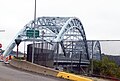
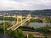
The McKees Rocks Bridge is a steel trussed through arch bridge which carries the Blue Belt, Pittsburgh's innermost beltline, across the Ohio River at Brighton Heights and McKees Rocks, Pennsylvania, connecting Pennsylvania Route 65 with Pennsylvania Route 51, west of the city.
History and architectural features
At 7,293 feet (2,223 m) long, this historic bridge is the longest bridge in Allegheny County.[3]
Built in 1931, it was listed on the National Register of Historic Places in 1988.[2][4]
The stretch of the bridge from Island Avenue was the successor to the O'Donovan Bridge, which ran from Island Avenue to the "Bottoms" of McKees Rocks from 1904 to 1931.
See also
- List of bridges documented by the Historic American Engineering Record in Pennsylvania
- List of crossings of the Ohio River
Gallery
-
 McKee's Rocks Bridge

References
- ^ Historic Landmark Plaques 1968-2009 (PDF). Pittsburgh, PA: Pittsburgh History & Landmarks Foundation. 2010. Retrieved 2011-08-05.
- ^ a b "National Register Information System". National Register of Historic Places. National Park Service. April 15, 2008.
- ^ Rotenstein, David S. (1997). "McKee's Rocks Bridge" (PDF). Historic American Engineering Record. Washington, D.C.: Library of Congress. Retrieved January 25, 2018.
- ^ "McKees Rocks Bridge" (PDF). Pennsylvania Historic Resource Survey Form. Pennsylvania Historical and Museum Commission. Retrieved January 10, 2014.
External links
Wikimedia Commons has media related to McKees Rocks Bridge.
- Historic American Engineering Record (HAER) No. PA-445, "McKee's Rocks Bridge, Spanning Ohio River at Chartiers Avenue (State Route 3014), McKees Rocks, Allegheny County, PA", 17 photos, 15 data pages
- McKees Rocks Bridge at HistoricBridges.org
Bridges of the Ohio River | ||||
|---|---|---|---|---|
| ||||


- v
- t
- e
- 30th Street Bridge
- 31st Street Bridge
- 33rd Street Railroad Bridge
- 40th Street Bridge
- Bloomfield Bridge
- Birmingham Bridge
- Charles Anderson Memorial Bridge
- David McCullough Bridge
- Fort Duquesne Bridge
- Fort Pitt Bridge
- Fort Wayne Railroad Bridge
- Glenwood Bridge
- Glenwood B&O Railroad Bridge
- Greenfield Bridge
- Highland Park Bridge
- Homestead Grays Bridge
- Hot Metal Bridge
- Liberty Bridge
- McKees Rocks Bridge
- Panhandle Bridge
- Panther Hollow Bridge
- Schenley Bridge
- Senator Robert D. Fleming Bridge
- Smithfield Street Bridge
- South Tenth Street Bridge
- Swindell Bridge
- Three Sisters
- Veterans Bridge
- West End Bridge
| ||
|---|---|---|
| Topics |  | |
| Lists by county |
| |
| Lists by city | ||
| Other lists | ||
| ||


| Authority control databases: Geographic |
|
|---|


