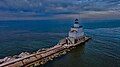
Manitowoc Breakwater Light
Lighthouse
44°05′33.918″N 87°38′36.91″W / 44.09275500°N 87.6435861°W / 44.09275500; -87.6435861[1]The Manitowoc Breakwater Light is a Lake Michigan lighthouse located near Manitowoc in Manitowoc County, Wisconsin, at the end of the north pier defining Manitowoc's harbor.[2]
It is not to be confused with the smaller and complementary south pier navigational beacon, which was unmoored and swept out into the lake on January 7, 2019, during a period of heavy waves and lakeshore flooding from gusty winds.[3][4]
Images

References
- ^ a b c Light List, Volume VII, Great Lakes (PDF). Light List. United States Coast Guard. 2014.
- ^ "Manitowoc Breakwater Lighthouse". Lighthouse Friends. Retrieved 18 April 2021.
- ^ Zarling, Patti (7 January 2019). "Manitowoc South Pier beacon swept away near lighthouse in high waves on Lake Michigan". Herald Times Reporter. Retrieved 7 January 2019.
- ^ "U.S. Lighthouse in Lake Michigan washed away by large waves". ABC News. January 8, 2019. Archived from the original (Videos) on January 8, 2019. Retrieved January 8, 2019.
Further reading
- Havighurst, Walter (1943) The Long Ships Passing: The Story of the Great Lakes, Macmillan Publishers.
- Oleszewski, Wes, Great Lakes Lighthouses, American and Canadian: A Comprehensive Directory/Guide to Great Lakes Lighthouses, (Gwinn, Michigan: Avery Color Studios, Inc., 1998) ISBN 0-932212-98-0.
- Sapulski, Wayne S., (2001) Lighthouses of Lake Michigan: Past and Present (Paperback) (Fowlerville: Wilderness Adventure Books) ISBN 0-923568-47-6; ISBN 978-0-923568-47-4.
- Wright, Larry and Wright, Patricia, Great Lakes Lighthouses Encyclopedia Hardback (Erin: Boston Mills Press, 2006) ISBN 1-55046-399-3.
External links
- NPS Inventory of Historic Light Stations - Wisconsin Archived 2006-02-09 at the Wayback Machine
- Rowlett, Russ. "Lighthouses of the United States: Eastern Wisconsin". The Lighthouse Directory. University of North Carolina at Chapel Hill.
- "Historic Light Station Information and Photography: Wisconsin". United States Coast Guard Historian's Office. Archived from the original on 2017-05-01.
- Light List, Volume VII, Great Lakes (PDF). Light List. United States Coast Guard.
- Historic American Engineering Record (HAER) No. WI-111, "Manitowoc Breakwater Light Station, North breakwater at mouth of the Manitowoc River, Manitowoc, Manitowoc County, WI", 19 photos, 1 data page, 5 photo caption pages
- v
- t
- e
Lighthouses of Wisconsin
- Ashland Harbor Breakwater
- Chequamegon Point
- Devils Island
- Gull Island
- La Pointe
- Michigan Island
- Outer Island
- Raspberry Island
- Sand Island
- Wisconsin Point
- Algoma
- Baileys Harbor
- Baileys Harbor Range
- Cana Island
- Chambers Island
- Dunlap Reef Range
- Eagle Bluff
- Grassy Island Range
- Green Bay Harbor Entrance
- Green island
- Kenosha
- Kenosha North Pier
- Kevich
- Kewaunee Pierhead
- Long Tail
- Manitowoc Breakwater
- Milwaukee Breakwater
- Milwaukee Pierhead
- North Point
- Peshtigo Reef
- Pilot Island
- Plum Island Range
- Port Washington
- Port Washington Breakwater
- Pottawatomie
- Racine Harbor
- Racine North Breakwater
- Racine Reef
- Rawley Point
- Sheboygan
- Sherwood Point
- Sturgeon Bay Canal
- Sturgeon Bay Canal North Pierhead
- Two Rivers
- Wind Point
- Dunlap Reef Range Front
- Manitowoc Main
- Manitowoc North Pierhead
- Plum Island Range Front
- Racine North Pierhead
| Authority control databases: Geographic |
|
|---|
 | This Wisconsin-related article is a stub. You can help Wikipedia by expanding it. |
- v
- t
- e
This article relating to a United States lighthouse is a stub. You can help Wikipedia by expanding it. |
- v
- t
- e


