Lone Star, South Carolina
Place in South Carolina, United States
Lone Star, South Carolina | |
|---|---|
 | |
| Country | United States |
| State | South Carolina |
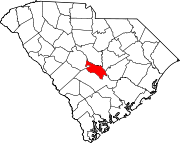
| Counties | Calhoun |
| Elevation | 171 ft (52 m) |
| Time zone | EST |
| • Summer (DST) | EDT |
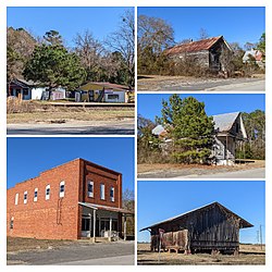
Lone Star is an unincorporated community in Calhoun County, South Carolina, United States. The community has the ZIP Code of 29030 and lies at approximately 33.63 latitude and -80.59 longitude, with an elevation of 171 feet. It is part of the Columbia, South Carolina Metropolitan Statistical Area.
South Carolina Highway 33 runs between Lone Star, and Orangeburg.
References

- HomeTownLocator.com: Lone Star, South Carolina
- HomeTownLocator.com: Populated Places in Calhoun County
- v
- t
- e
Municipalities and communities of Calhoun County, South Carolina, United States
County seat: St. Matthews
communities
- Lone Star
- Sandy Run
- South Carolina portal
- United States portal
33°37′32″N 80°35′22″W / 33.62556°N 80.58944°W / 33.62556; -80.58944
 | This South Carolina state location article is a stub. You can help Wikipedia by expanding it. |
- v
- t
- e


