List of provincial parks of the Lower Mainland
The list of provincial parks of the Lower Mainland contains the provincial parks located within this geographic region of the province of British Columbia. It includes parks from the two regional districts of Fraser Valley and Metro Vancouver. These parks are administered by BC Parks under the jurisdiction of the Ministry of Environment and Climate Change Strategy.
Parks
Fraser Valley Regional District
| Name | Established | Commons category | Picture | Coordinates |
|---|---|---|---|---|
| Alexandra Bridge Provincial Park | 1984-07-26 | Alexandra Bridge (1926) |  | 49°42′N 121°24′W / 49.7°N 121.4°W / 49.7; -121.4 |
| Bridal Veil Falls Provincial Park | 1965 | Bridal Veil Falls Provincial Park | 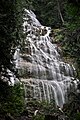 | 49°11′00″N 121°43′59″W / 49.1833°N 121.733°W / 49.1833; -121.733 |
| Cascade Recreation Area | 49°16′00″N 120°55′59″W / 49.2667°N 120.933°W / 49.2667; -120.933 | |||
| Chilliwack Lake Provincial Park | 1973 |  | 49°02′30″N 121°24′40″W / 49.0417°N 121.411°W / 49.0417; -121.411 | |
| Chilliwack River Provincial Park | 1961[1] | 49°04′48″N 121°53′10″W / 49.08°N 121.886°W / 49.08; -121.886 | ||
| Coquihalla Canyon Provincial Park | 1986-05-15 | Coquihalla Canyon Provincial Park |  | 49°22′13″N 121°22′08″W / 49.3703°N 121.369°W / 49.3703; -121.369 |
| Coquihalla River Provincial Park | 1986 | 49°27′40″N 121°15′36″W / 49.461°N 121.26°W / 49.461; -121.26 | ||
| Cultus Lake Provincial Park | 1948-02-10 |  | 49°02′11″N 121°58′28″W / 49.036388888889°N 121.97444444444°W / 49.036388888889; -121.97444444444 | |
| Davis Lake Provincial Park | 1963 | Davis Lake Provincial Park |  | 49°18′00″N 122°13′59″W / 49.3°N 122.233°W / 49.3; -122.233 |
| E. C. Manning Provincial Park | 1941 | Manning Park |  | 49°04′00″N 120°46′59″W / 49.0667°N 120.783°W / 49.0667; -120.783 |
| Emory Creek Provincial Park | 1956 | 49°31′00″N 121°25′01″W / 49.5167°N 121.417°W / 49.5167; -121.417 | ||
| F. H. Barber Provincial Park | 1978 | 49°18′50″N 121°38′06″W / 49.314°N 121.6349°W / 49.314; -121.6349 | ||
| Ferry Island Provincial Park | 1963[2] | 49°12′06″N 121°46′53″W / 49.2017°N 121.7815°W / 49.2017; -121.7815 | ||
| Kilby Provincial Park | 1973-08-28 | Kilby Store and Farm |  | 49°14′15″N 121°57′40″W / 49.2375°N 121.961°W / 49.2375; -121.961 |
| Mehatl Creek Provincial Park | 1997 | 50°03′00″N 122°01′59″W / 50.05°N 122.033°W / 50.05; -122.033 | ||
| Nicolum River Provincial Park | 1956[3] | 49°22′00″N 121°20′31″W / 49.3667°N 121.342°W / 49.3667; -121.342 | ||
| Rolley Lake Provincial Park | February 3, 1961[4] | 49°14′35″N 122°23′13″W / 49.243°N 122.387°W / 49.243; -122.387 | ||
| Sasquatch Provincial Park | 1968 |  | 49°21′N 121°42′W / 49.35°N 121.7°W / 49.35; -121.7 | |
| Silver Lake Provincial Park | February 1964[5] | 49°19′00″N 121°24′00″W / 49.3167°N 121.4°W / 49.3167; -121.4 | ||
| Skagit Valley Provincial Park | 1973 | Skagit Valley Provincial Park | 49°07′00″N 121°10′01″W / 49.1167°N 121.167°W / 49.1167; -121.167 |
Metro Vancouver
| # | Name | Established | Commons category | Picture | Coordinates |
|---|---|---|---|---|---|
| 1 | Apodaca Provincial Park | 49°21′16″N 123°20′23″W / 49.3545°N 123.3398°W / 49.3545; -123.3398 | |||
| 2 | Cypress Provincial Park | 1975 | Cypress Provincial Park |  | 49°23′30″N 123°12′47″W / 49.3917°N 123.213°W / 49.3917; -123.213 |
| 3 | Golden Ears Provincial Park | 1967-12-14 | Golden Ears Provincial Park |  | 49°28′00″N 122°27′00″W / 49.4667°N 122.45°W / 49.4667; -122.45 |
| 4 | Indian Arm Provincial Park | 1995 | 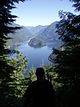 | 49°26′00″N 122°52′00″W / 49.43333333°N 122.86666667°W / 49.43333333; -122.86666667 | |
| 5 | Mount Seymour Provincial Park | 1936 |  | 49°23′06″N 122°56′06″W / 49.385°N 122.935°W / 49.385; -122.935 | |
| 6 | Peace Arch Park | Peace Arch Park |  | 49°00′00″N 122°45′25″W / 49°N 122.757°W / 49; -122.757 | |
| 7 | Pinecone Burke Provincial Park | 49°23′36″N 122°42′25″W / 49.3933°N 122.707°W / 49.3933; -122.707 | |||
| 8 | Minnekhada Regional Park | Minnekhada Regional Park |  | 49°18′05″N 122°41′42″W / 49.3015°N 122.6949°W / 49.3015; -122.6949 |
References
- ^ "Chilliwack River Provincial Park - BC Parks". Env.gov.bc.ca. Retrieved 2022-03-20.
- ^ "Ferry Island Provincial Park - BC Parks". Env.gov.bc.ca. Retrieved 2022-03-20.
- ^ "Nicolum River Provincial Park - BC Parks". Env.gov.bc.ca. Retrieved 2022-03-20.
- ^ "Rolley Lake Provincial Park - BC Parks". Env.gov.bc.ca. 1961-02-03. Retrieved 2022-03-20.
- ^ "Silver Lake Provincial Park - BC Parks". Env.gov.bc.ca. Retrieved 2022-03-20.
External links
Map all coordinates using OpenStreetMap
Download coordinates as:
- KML
- GPX (all coordinates)
- GPX (primary coordinates)
- GPX (secondary coordinates)
![]() Media related to Provincial Parks of British Columbia at Wikimedia Commons
Media related to Provincial Parks of British Columbia at Wikimedia Commons
- Map of provincial parks in the Lower Mainland on env.gov.bc.ca
- v
- t
- e
- CRHP
- Alberni-Clayoquot RD
- BC Coast
- Capital RD
- Kootenay RD
- Columbia-Shuswap RD
- Comox Valley RD
- Cowichan Valley RD
- East Kootenay RD
- Fraser Valley RD
- Kootenay Boundary RD
- Nanaimo RD
- New Westminster
- North Okanagan RD
- North Shore
- Northern/Central BC Interior
- Okanagan-Similkameen RD
- Squamish-Lillooet RD
- Strathcona RD
- Surrey
- Thompson-Nicola RD
- Vancouver
- Victoria
| |||||
| |||||||
| |||||
| |||||
Wildlife Management Areas | |
|---|---|
|
Other | |
|---|---|
|
 Category
- BC Parks
 Commons


