List of hillside letters


Map all coordinates using OpenStreetMap
Download coordinates as:
- KML
- GPX (all coordinates)
- GPX (primary coordinates)
- GPX (secondary coordinates)
This is a list of hillside letters (also known as mountain monograms), large geoglyphs found primarily in the Western United States.[1][2][3] There are about 600 in total, but the status of many of these symbols are uncertain, due to vagueness in sources.
The states with the most hillside letters are:
- Montana: 86 monograms
- California: 83 monograms
- Utah: 83 monograms
- Arizona: 63 monograms
- Nevada: 47 monograms
- Oregon: 39 monograms
- Idaho: 36 monograms
This list is incomplete; you can help by adding missing items. (June 2011) |
United States
Arizona
California
Colorado
At least 31 monograms, possibly 33.
| Monogram | Town | Description | Coordinates |
|---|---|---|---|
| A | Fort Collins | Colorado State University (formerly the Aggies) | 40°33′40″N 105°09′04″W / 40.561°N 105.151°W / 40.561; -105.151 (Colorado State University) |
| B | Branson | 37°00′33″N 103°52′53″W / 37.0092°N 103.8815°W / 37.0092; -103.8815 (Branson) | |
| C | Cañon City | 38°26′35″N 105°15′00″W / 38.443°N 105.25°W / 38.443; -105.25 (Cañon City) | |
| D | Del Norte | 37°40′19″N 106°21′32″W / 37.6719°N 106.3588°W / 37.6719; -106.3588 (Del Norte) | |
| D | Dinosaur | 40°14′47″N 109°00′23″W / 40.2463°N 109.0064°W / 40.2463; -109.0064 (Dinosaur) | |
| F | Fruita | Fruita Monument High School | 39°08′00″N 108°44′01″W / 39.1334524°N 108.7336039°W / 39.1334524; -108.7336039 (Fruita) |
| G | Golden | 39°45′08″N 105°12′24″W / 39.7521°N 105.2066°W / 39.7521; -105.2066 (Golden) | |
| GV | Parachute | Grand Valley High School | 39°27′40″N 108°03′15″W / 39.461°N 108.0542°W / 39.461; -108.0542 (Grand Valley High School) |
| GM | Lakewood | Green Mountain High School | 39°41′47″N 105°08′40″W / 39.6964°N 105.1444°W / 39.6964; -105.1444 (Green Mountain High School) |
| G | Gunnison | 38°33′04″N 106°54′52″W / 38.551°N 106.9144°W / 38.551; -106.9144 (Gunnison) | |
| H | Hotchkiss | 38°47′32″N 107°42′03″W / 38.7923°N 107.7008°W / 38.7923; -107.7008 (Hotchkiss) | |
| LV | La Veta | 37°31′21″N 105°00′25″W / 37.5224°N 105.007°W / 37.5224; -105.007 (La Veta) | |
| LHS | Sopris | Lincoln High School | 37°07′51″N 104°34′21″W / 37.1308°N 104.5724°W / 37.1308; -104.5724 (Sopris) |
| L | Loma | 39°11′22″N 108°50′35″W / 39.1894°N 108.843°W / 39.1894; -108.843 (Loma) | |
| L | Lyons | 40°12′34″N 105°15′56″W / 40.2095°N 105.2656°W / 40.2095; -105.2656 (Lyons) | |
| M | Golden | Colorado School of Mines | 39°44′43″N 105°14′24″W / 39.7453°N 105.24°W / 39.7453; -105.24 (Colorado School of Mines) |
| M | Manassa | 37°09′23″N 105°55′56″W / 37.1564°N 105.9323°W / 37.1564; -105.9323 (Manassa) | |
| M | Montrose | 38°28′42″N 107°52′34″W / 38.4783°N 107.8762°W / 38.4783; -107.8762 (Montrose) | |
| P (uncertain existence) | Pagosa Springs | 37°16′04″N 107°00′36″W / 37.2677°N 107.01°W / 37.2677; -107.01 (Pagosa Springs) (uncertain location) | |
| P | Palisade | 39°05′29″N 108°20′51″W / 39.0914°N 108.3474°W / 39.0914; -108.3474 (Palisade) | |
| P | Paonia | 38°51′35″N 107°35′51″W / 38.8596°N 107.5976°W / 38.8596; -107.5976 (Paonia) | |
| P | Weston | Primero High School | 37°07′27″N 104°47′37″W / 37.1241°N 104.7936°W / 37.1241; -104.7936 (Weston) |
| R | Rangely | Rangely High School | 40°05′03″N 108°48′00″W / 40.0841°N 108.7999°W / 40.0841; -108.7999 (Rangely) |
| R (uncertain existence) | Rifle | 39°31′48″N 107°47′00″W / 39.5301°N 107.7832°W / 39.5301; -107.7832 (Rifle) (uncertain location) | |
| S | Saguache | 38°05′01″N 106°07′43″W / 38.0837°N 106.1287°W / 38.0837; -106.1287 (Saguache) | |
| S | Salida | 38°32′28″N 105°59′15″W / 38.541°N 105.9876°W / 38.541; -105.9876 (Salida) | |
| SAN LUIS OLDEST TOWN IN COLO. | San Luis | 37°12′01″N 105°25′41″W / 37.2004°N 105.4281°W / 37.2004; -105.4281 (San Luis) | |
| S | Sanford | 37°14′55″N 105°48′00″W / 37.2487°N 105.8°W / 37.2487; -105.8 (Sanford) | |
| SANTA MARIA | Santa Maria | 39°27′09″N 105°37′51″W / 39.4524°N 105.6307°W / 39.4524; -105.6307 (Santa Maria) | |
| SHS | Sheridan | Sheridan High School | 39°38′20″N 105°01′43″W / 39.639°N 105.0287°W / 39.639; -105.0287 (Sheridan High School) |
| S | Silverton | 37°49′04″N 107°39′52″W / 37.8177°N 107.6644°W / 37.8177; -107.6644 (Silverton) | |
| SL | Westminster | Standley Lake High School | 39°53′04″N 105°05′50″W / 39.8844°N 105.0971°W / 39.8844; -105.0971 (Standley Lake High School) |
| W | Gunnison | Western Colorado University | 38°31′39″N 106°54′30″W / 38.5274°N 106.9084°W / 38.5274; -106.9084 (Western State College) |
-
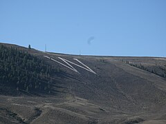 Western Colorado University's W Mountain
 -
 South Table Mountain Golden, Colorado
 -
 Salida Downtown Historic District in Salida, Colorado
 -
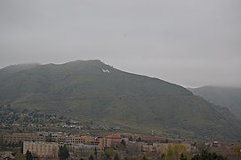 Mount Zion Mountain west of Golden, Colorado


Idaho
Maryland
| Monogram | Town | Description | Coordinates |
|---|---|---|---|
| MVGC (no longer exists) | Montgomery Village | Initialism of "Montgomery Village Golf Club"[4] | 39°10′54″N 77°11′58″W / 39.1817904°N 77.1995232°W / 39.1817904; -77.1995232 (Gaithersburg) |
Montana
Nevada
New Mexico
At least 30 monograms, possibly 37
| Monogram | Town | Description | Coordinates |
|---|---|---|---|
| A | Alamogordo | 32°54′01″N 105°54′40″W / 32.9002°N 105.911°W / 32.9002; -105.911 (Alamogordo) | |
| A | Aztec | 36°50′09″N 108°00′33″W / 36.8357°N 108.0091°W / 36.8357; -108.0091 (Aztec) | |
| A | Aggies | 32°17′35″N 106°41′53″W / 32.292978°N 106.697936°W / 32.292978; -106.697936 (Las Cruces) | |
| B | Bernalillo | 35°19′15″N 106°31′46″W / 35.3209°N 106.5295°W / 35.3209; -106.5295 (Bernalillo) | |
| B | Bloomfield | 36°43′35″N 107°58′48″W / 36.7263°N 107.9799°W / 36.7263; -107.9799 (Bloomfield) | |
| C | Capitan | 33°32′14″N 105°35′02″W / 33.5373°N 105.584°W / 33.5373; -105.584 (Capitan) | |
| C | Cimarron | 36°29′57″N 104°55′20″W / 36.4992°N 104.9222°W / 36.4992; -104.9222 (Cimarron) | |
| C | Costilla | 36°59′20″N 105°30′48″W / 36.9888°N 105.5132°W / 36.9888; -105.5132 (Costilla) | |
| E | El Rito | 36°21′36″N 106°10′48″W / 36.36°N 106.1801°W / 36.36; -106.1801 (El Rito) | |
| E (uncertain existence) | Espanola | 35°59′26″N 106°04′48″W / 35.9905°N 106.08°W / 35.9905; -106.08 (Espanola) (uncertain location) | |
| F | Farmington | 36°45′49″N 108°11′27″W / 36.7637°N 108.1909°W / 36.7637; -108.1909 (Farmington) | |
| G | Grants | 35°10′07″N 107°51′50″W / 35.1685°N 107.864°W / 35.1685; -107.864 (Grants) (uncertain location) | |
| H | Las Vegas | New Mexico Highlands University | 35°35′26″N 105°12′21″W / 35.5905°N 105.2059°W / 35.5905; -105.2059 (New Mexico Highlands University) |
| H | Hondo | 33°23′00″N 105°15′13″W / 33.3833°N 105.2537°W / 33.3833; -105.2537 (Hondo) | |
| KS | Kirtland | Kirtland Street High School | 36°45′33″N 108°22′22″W / 36.7591°N 108.3729°W / 36.7591; -108.3729 (Kirtland Central High School) |
| LA | Laguna | Laguna-Acoma | 35°03′13″N 107°26′19″W / 35.0537°N 107.4387°W / 35.0537; -107.4387 (Laguna-Acoma) |
| L | Lordsburg | 32°19′43″N 108°43′36″W / 32.3287°N 108.7268°W / 32.3287; -108.7268 (Lordsburg) | |
| LA | Los Alamos | 35°54′00″N 106°19′58″W / 35.9°N 106.3329°W / 35.9; -106.3329 (Los Alamos) | |
| LL | Los Lunas | 34°48′25″N 106°47′29″W / 34.807°N 106.7914°W / 34.807; -106.7914 (Los Lunas) | |
| L (uncertain existence) | Lyden | 36°08′47″N 106°00′20″W / 36.1463°N 106.0056°W / 36.1463; -106.0056 (Lyden) (uncertain location) | |
| M | Magdalena | 34°05′42″N 107°15′04″W / 34.0949°N 107.2512°W / 34.0949; -107.2512 (Magdalena) | |
| MV | Ojo Caliente | Mesa Vista High School | 36°19′53″N 106°02′21″W / 36.3315°N 106.0391°W / 36.3315; -106.0391 (Mesa Vista High School) |
| M (uncertain existence) | Mora | 35°58′26″N 105°19′43″W / 35.974°N 105.3287°W / 35.974; -105.3287 (Mora) (uncertain location) | |
| A | Las Cruces | New Mexico State University Aggies | 32°17′33″N 106°41′56″W / 32.2926°N 106.699°W / 32.2926; -106.699 (New Mexico State University Aggies) |
| M | Socorro | New Mexico Tech Miners | 34°04′20″N 106°57′34″W / 34.0723°N 106.9594°W / 34.0723; -106.9594 (New Mexico Tech Miners) |
| N | Newcomb | Newcomb Elementary School | 36°16′56″N 108°42′40″W / 36.282207°N 108.711151°W / 36.282207; -108.711151 (Newcomb High School) |
| N | Newcomb | Newcomb Middle School | 36°16′44″N 108°42′46″W / 36.278943°N 108.712849°W / 36.278943; -108.712849 (Newcomb Middle School) |
| P | Penasco | 36°10′35″N 105°41′04″W / 36.1765°N 105.6845°W / 36.1765; -105.6845 (Penasco) | |
| P | Pojoaque | 35°53′31″N 106°01′16″W / 35.892°N 106.021°W / 35.892; -106.021 (Pojoaque) | |
| Q | Questa | 36°42′36″N 105°34′09″W / 36.7099°N 105.5693°W / 36.7099; -105.5693 (Questa) | |
| R | Las Vegas | Robertson High School | 35°34′50″N 105°12′09″W / 35.5805°N 105.2025°W / 35.5805; -105.2025 (Robertson High School) |
| X (uncertain existence) | Santa Fe | 35°40′53″N 105°56′48″W / 35.6813°N 105.9467°W / 35.6813; -105.9467 (Santa Fe) (uncertain location) | |
| S (uncertain existence) | Shiprock | 36°47′27″N 108°40′58″W / 36.7907°N 108.6828°W / 36.7907; -108.6828 (Shiprock) (uncertain location) | |
| J | Albuquerque | St. Joseph's College (closed) | 35°08′29″N 106°46′17″W / 35.1414°N 106.7714°W / 35.1414; -106.7714 (St. Joseph's College (closed)) |
| T | Truth or Consequences | 33°07′09″N 107°13′39″W / 33.1191°N 107.2275°W / 33.1191; -107.2275 (Truth or Consequences) | |
| T | Tohatchi | Tohatchi High School | 35°51′20″N 108°44′51″W / 35.855677°N 108.747394°W / 35.855677; -108.747394 (Tohatchi High School) |
| T | Tucumcari | 35°08′04″N 103°42′00″W / 35.1345°N 103.7°W / 35.1345; -103.7 (Tucumcari) | |
| U (no longer exists) | Albuquerque | University of New Mexico | 35°04′52″N 106°28′54″W / 35.0812°N 106.4816°W / 35.0812; -106.4816 (University of New Mexico) |
| WM | Wagon Mound | 36°00′18″N 104°42′07″W / 36.0051°N 104.7019°W / 36.0051; -104.7019 (Wagon Mound) | |
| D | Las Vegas | West Las Vegas High School Dons | 35°35′21″N 105°12′17″W / 35.5893°N 105.2047°W / 35.5893; -105.2047 (West Las Vegas High School Dons) |
| W | Silver City | Western New Mexico University | 32°49′38″N 108°14′56″W / 32.8272°N 108.2489°W / 32.8272; -108.2489 (Western New Mexico University) |
Oregon
Texas
Texas' 16 or more monograms are all in the westernmost mountainous, part of the state. There are six (in various states of repair) in El Paso alone, the most in any single city in the United States.
| Monogram | Town | Description | Coordinates |
|---|---|---|---|
| A | Alpine | 30°21′10″N 103°39′23″W / 30.3527°N 103.6564°W / 30.3527; -103.6564 (Alpine) | |
| A | El Paso | Austin High School | 31°47′59″N 106°28′26″W / 31.7998°N 106.474°W / 31.7998; -106.474 (Austin High School) |
| B | Balmorhea | 30°58′33″N 103°43′12″W / 30.9757°N 103.7199°W / 30.9757; -103.7199 (Balmorhea) | |
| B/E | El Paso | Bowie High School | 31°47′10″N 106°28′47″W / 31.7861°N 106.4796°W / 31.7861; -106.4796 (Bowie High School) |
| C (removed?) | El Paso | Cathedral High School | 31°47′34″N 106°28′53″W / 31.7928°N 106.4813°W / 31.7928; -106.4813 (Cathedral High School) |
| E/B | El Paso | El Paso High School | 31°47′12″N 106°28′49″W / 31.7867°N 106.4803°W / 31.7867; -106.4803 (El Paso High School) |
| FD | Fort Davis | 30°34′42″N 103°53′35″W / 30.5784°N 103.893°W / 30.5784; -103.893 (Fort Davis) | |
| I? | Iraan | 30°54′00″N 101°53′54″W / 30.8999°N 101.8983°W / 30.8999; -101.8983 (Iraan) | |
| J | El Paso | Jefferson High School | 31°47′11″N 106°28′42″W / 31.7865°N 106.4783°W / 31.7865; -106.4783 (Jefferson High School) |
| M | Marathon | 30°12′29″N 103°13′20″W / 30.208006°N 103.222237°W / 30.208006; -103.222237 (Marathon) | |
| M (uncertain existence) | Marfa | 30°18′32″N 104°01′15″W / 30.3088°N 104.0207°W / 30.3088; -104.0207 (Marfa) (uncertain location) | |
| M | McCamey | 31°05′59″N 102°09′20″W / 31.0998°N 102.1555°W / 31.0998; -102.1555 (McCamey) | |
| P (uncertain existence) | Presidio | 29°33′52″N 104°22′08″W / 29.5644°N 104.3689°W / 29.5644; -104.3689 (Presidio) (uncertain location) | |
| S | Sanderson | 30°08′48″N 102°24′01″W / 30.1467°N 102.4004°W / 30.1467; -102.4004 (Sanderson) | |
| S | Shafter | 29°49′19″N 104°18′15″W / 29.8219°N 104.3041°W / 29.8219; -104.3041 (Shafter) | |
| SB | Sierra Blanca | 31°11′16″N 105°20′58″W / 31.1878°N 105.3495°W / 31.1878; -105.3495 (Sierra Blanca) | |
| SR | Alpine | Sul Ross State University | 30°21′58″N 103°38′51″W / 30.3662°N 103.6474°W / 30.3662; -103.6474 (Sul Ross State University) |
| SAFETY FIRST! | Iraan | 30°53′58″N 101°53′44″W / 30.89944°N 101.89556°W / 30.89944; -101.89556 (Iraan) | |
| M | El Paso | UTEP Miners | 31°46′36″N 106°30′32″W / 31.7767°N 106.5088°W / 31.7767; -106.5088 (UTEP Miners) |
| V | Van Horn | 31°03′31″N 104°51′38″W / 31.0585°N 104.8606°W / 31.0585; -104.8606 (Van Horn) |
Utah
Washington
Most of Washington's 18 to 19 monograms are in the arid Eastern part of the state.
| Monogram | Town | Description | Coordinates |
|---|---|---|---|
| #7 | Ephrata | 47°19′13″N 119°34′17″W / 47.3204°N 119.5714°W / 47.3204; -119.5714 (Ephrata) | |
| A | Asotin | 46°20′27″N 117°03′34″W / 46.3407°N 117.0594°W / 46.3407; -117.0594 (Asotin) | |
| B | Burlington | 48°28′58″N 122°19′30″W / 48.4827°N 122.325°W / 48.4827; -122.325 (Burlington) | |
| C | Cashmere | 47°31′46″N 120°28′04″W / 47.5294°N 120.4678°W / 47.5294; -120.4678 (Cashmere) | |
| C | Clarkston | 46°27′00″N 117°02′49″W / 46.45°N 117.047°W / 46.45; -117.047 (Clarkston) | |
| C | Colville | 48°33′47″N 117°54′03″W / 48.5631°N 117.9009°W / 48.5631; -117.9009 (Colville) | |
| C | Creston | 47°44′42″N 118°31′44″W / 47.7449°N 118.5289°W / 47.7449; -118.5289 (Creston) | |
| E | East Wenatchee | 47°26′34″N 120°16′57″W / 47.4428°N 120.2824°W / 47.4428; -120.2824 (East Wenatchee) | |
| FOSS | Tacoma | Foss High School | 47°14′10″N 122°29′37″W / 47.236°N 122.4937°W / 47.236; -122.4937 (Foss High School) |
| G | Goldendale | 45°48′06″N 120°47′45″W / 45.8016°N 120.7957°W / 45.8016; -120.7957 (Goldendale) | |
| K | Kelso | 46°08′51″N 122°53′46″W / 46.1475°N 122.8962°W / 46.1475; -122.8962 (Kelso) | |
| KF | Kettle Falls | 48°36′59″N 118°02′24″W / 48.6164°N 118.04°W / 48.6164; -118.04 (Kettle Falls) | |
| K | Klickitat | 45°48′51″N 121°08′57″W / 45.8143°N 121.1493°W / 45.8143; -121.1493 (Klickitat) | |
| L | Union Gap | La Salle High School | 46°31′54″N 120°27′50″W / 46.5317°N 120.4639°W / 46.5317; -120.4639 (La Salle High School) |
| OK | Okanogan | 48°21′57″N 119°35′15″W / 48.3658°N 119.5876°W / 48.3658; -119.5876 (Okanogan) | |
| R | Richland | 46°14′11″N 119°18′45″W / 46.2364°N 119.3126°W / 46.2364; -119.3126 (Richland) | |
| R | Rosalia | 47°13′41″N 117°22′33″W / 47.228168°N 117.375771°W / 47.228168; -117.375771 (Rosalia) | |
| S | Selah | 46°37′55″N 120°31′46″W / 46.631846°N 120.529443°W / 46.631846; -120.529443 (Selah) | |
| T (uncertain existence) | Touchet |
Wyoming
Between 24 and 25 monograms
| Monogram | Town | Description | Coordinates |
|---|---|---|---|
| B | Burlington | 44°27′58″N 108°25′53″W / 44.466°N 108.4315°W / 44.466; -108.4315 (Burlington) | |
| C | Cody | 44°31′34″N 109°06′04″W / 44.5262°N 109.101°W / 44.5262; -109.101 (Cody) | |
| D | Douglas | 42°45′09″N 105°21′41″W / 42.7524°N 105.3615°W / 42.7524; -105.3615 (Douglas) | |
| E | Evanston | 41°15′30″N 110°57′21″W / 41.2583°N 110.9559°W / 41.2583; -110.9559 (Evanston) | |
| F | Fairview | 42°40′51″N 111°00′40″W / 42.6807°N 111.0112°W / 42.6807; -111.0112 (Fairview) | |
| FORT WASHAKIE | Fort Washakie | 43°00′48″N 108°52′50″W / 43.0132°N 108.8805°W / 43.0132; -108.8805 (Fort Washakie) | |
| G | Glenrock | 42°51′31″N 105°51′04″W / 42.8585°N 105.8511°W / 42.8585; -105.8511 (Glenrock) | |
| GR | Green River | 41°30′53″N 109°28′47″W / 41.5147°N 109.4796°W / 41.5147; -109.4796 (Green River) | |
| G | Greybull | 44°30′00″N 108°04′27″W / 44.5°N 108.0742°W / 44.5; -108.0742 (Greybull) | |
| G | Guernsey | 42°15′52″N 104°44′01″W / 42.2644°N 104.7335°W / 42.2644; -104.7335 (Guernsey) | |
| H (uncertain existence) | Hartville | 42°19′38″N 104°43′38″W / 42.3272°N 104.7272°W / 42.3272; -104.7272 (Hartville) (uncertain location) | |
| WORLDS LARGEST MINERAL HOT SPRING | Thermopolis | Hot Springs State Park | 43°39′22″N 108°11′34″W / 43.6562°N 108.1929°W / 43.6562; -108.1929 (Hot Springs State Park) |
| K | Kemmerer | This is an old location see below | 41°47′34″N 110°31′35″W / 41.7929°N 110.5265°W / 41.7929; -110.5265 (Kemmerer) |
| K | Kemmerer | The new location. | 41.788611°N 110.529444°W |
| L | Lovell | 44°49′32″N 108°17′50″W / 44.825629°N 108.297097°W / 44.825629; -108.297097 (Lovell) | |
| M | Meeteetse | 44°09′09″N 108°52′13″W / 44.1526°N 108.8703°W / 44.1526; -108.8703 (Meeteetse) | |
| M | Meeteetse | 44°09′09″N 108°52′13″W / 44.1526°N 108.8703°W / 44.1526; -108.8703 (Meeteetse) | |
| MV | Mountain View | 41°15′43″N 110°20′27″W / 41.2620°N 110.3408°W / 41.2620; -110.3408 (Rawlins) | |
| R | Basin | Riverside High School | 44°22′47″N 108°03′27″W / 44.3797°N 108.0575°W / 44.3797; -108.0575 (Riverside High School) |
| RS | Rock Springs | 41°36′00″N 109°12′49″W / 41.6°N 109.2136°W / 41.6; -109.2136 (Rock Springs) | |
| * | Afton | Star Valley | 42°43′49″N 110°54′42″W / 42.7302°N 110.9118°W / 42.7302; -110.9118 (Star Valley) |
| S | Sunrise | 42°19′51″N 104°42′54″W / 42.3307°N 104.7149°W / 42.3307; -104.7149 (Sunrise) | |
| T | Ten Sleep | 44°02′41″N 107°26′48″W / 44.0448°N 107.4467°W / 44.0448; -107.4467 (Ten Sleep) | |
| T | Thermopolis | 43°39′18″N 108°12′23″W / 43.655°N 108.2064°W / 43.655; -108.2064 (Thermopolis) | |
| W | Laramie | University of Wyoming | 41°19′43″N 105°34′20″W / 41.3287°N 105.5721°W / 41.3287; -105.5721 (University of Wyoming) |
| W | Worland | 44°00′39″N 108°00′20″W / 44.0109°N 108.0055°W / 44.0109; -108.0055 (Worland) | |
| WBS | McNutt | Wyoming Boys' School |
Other states


| Monogram | Town | State | Description | Coordinates |
|---|---|---|---|---|
| DAYTONA BEACH LPGA BLVD | Daytona Beach | Florida | 29°13′10″N 81°06′13″W / 29.2195°N 81.1035°W / 29.2195; -81.1035 (Daytona Beach) | |
| PALM BAY | Palm Bay | Florida | 28°02′08″N 80°39′27″W / 28.0356°N 80.6574°W / 28.0356; -80.6574 (Palm Bay) | |
| L | Lahaina | Hawaii | 20°53′15″N 156°38′29″W / 20.8876°N 156.6415°W / 20.8876; -156.6415 (Lahaina) | |
| KS | Manhattan | Kansas | Kansas State University (K built in 1921) | 39°10′19″N 96°33′08″W / 39.172°N 96.5522°W / 39.172; -96.5522 (Kansas State University) |
| MANHATTAN | Manhattan | Kansas | Manhattan (built in 1927) | 39°11′33″N 96°33′46″W / 39.19245°N 96.56281°W / 39.19245; -96.56281 (Kansas State University) |
| OP | Ocean Pines | Maryland | 38°23′06″N 75°10′42″W / 38.3851°N 75.1782°W / 38.3851; -75.1782 (Ocean Pines) | |
| NB | New Bedford | Massachusetts | (Built 2010's) | 41°38′18″N 70°55′29″W / 41.6383°N 70.9247°W / 41.6383; -70.9247 (New Bedford) |
| C | Chadron | Nebraska | 42°48′55″N 103°00′10″W / 42.8152°N 103.0028°W / 42.8152; -103.0028 (Chadron) | |
| POTTER | Potter | Nebraska | 41°12′15″N 103°18′46″W / 41.2041°N 103.3128°W / 41.2041; -103.3128 (Potter) | |
| VALENTINE | Valentine | Nebraska | 42°51′19″N 100°32′31″W / 42.855412°N 100.541937°W / 42.855412; -100.541937 (Valentine) | |
| C | New York City (Manhattan) | New York | Columbia University | 40°52′34″N 73°55′08″W / 40.8761°N 73.919°W / 40.8761; -73.919 (Columbia University) |
| HOWE CAVERNS | Cobleskill | New York | Howe Caverns | 42°41′44″N 74°23′56″W / 42.6956°N 74.3989°W / 42.6956; -74.3989 (Howe Caverns) |
| M (uncertain existence) | Poughkeepsie | New York | Marist College | 41°43′16″N 73°56′52″W / 41.7212°N 73.9477°W / 41.7212; -73.9477 (Marist College) (uncertain location) |
| A | Alexander | North Dakota | 47°49′46″N 103°38′15″W / 47.8295°N 103.6376°W / 47.8295; -103.6376 (Alexander) | |
| HOME ON THE RANGE | Beach | North Dakota | Home on the Range Ranch | 46°56′37″N 103°52′09″W / 46.9435°N 103.8693°W / 46.9435; -103.8693 (Home on the Range Ranch) |
| K (uncertain existence) | Kenmare | North Dakota | 48°40′35″N 102°04′53″W / 48.6764°N 102.0814°W / 48.6764; -102.0814 (Kenmare) (uncertain location) | |
| MANDAN | Mandan | North Dakota | 46°50′01″N 100°52′16″W / 46.8336°N 100.8712°W / 46.8336; -100.8712 (Mandan) | |
| PRICE | Price | North Dakota | 47°04′54″N 100°56′36″W / 47.0818°N 100.9432°W / 47.0818; -100.9432 (Price) | |
| Z | Zap | North Dakota | 47°16′45″N 101°55′58″W / 47.2793°N 101.9328°W / 47.2793; -101.9328 (Zap) | |
| AKRON | Akron | Ohio | 41°02′25″N 81°27′26″W / 41.0403°N 81.4572°W / 41.0403; -81.4572 (Akron)[5] | |
| HOBAN | Akron | Ohio | Archbishop Hoban High School | 41°03′44″N 81°29′53″W / 41.0622°N 81.498°W / 41.0622; -81.498 (Archbishop Hoban High School)[5] |
| LAZY S RANCH | Springer | Oklahoma | Lazy S Ranch | 34°20′56″N 97°08′33″W / 34.349°N 97.1424°W / 34.349; -97.1424 (Lazy S Ranch) |
| WELCOME TO HERSHEY | Hershey | Pennsylvania | Hersheypark | 40°17′39″N 76°39′44″W / 40.2941°N 76.6623°W / 40.2941; -76.6623 (Hershey Park) |
| H | Spearfish | South Dakota | Black Hills State College | 44°30′26″N 103°51′04″W / 44.5073°N 103.851°W / 44.5073; -103.851 (Black Hills State College) |
| SMD | Rapid City | South Dakota | South Dakota School of Mines and Technology (M-Hill) | 44°05′18″N 103°14′58″W / 44.0883°N 103.2494°W / 44.0883; -103.2494 (S. D. School of Mines & Technology) |
| Σ Φ | Rapid City | South Dakota | South Dakota School of Mines and Technology Fraternal Organizations (Smelter Hill) | 44°04′15″N 103°12′05″W / 44.070798°N 103.201329°W / 44.070798; -103.201329 (S. D. School of Mines & Technology) |
| LU | Lynchburg | Virginia | Liberty University | 37°21′34″N 79°09′35″W / 37.3595°N 79.1597°W / 37.3595; -79.1597 (Liberty University) |
| St. Marys Springs | Fond du Lac | Wisconsin | St. Mary's Springs High School | 43°47′05″N 88°23′05″W / 43.7847°N 88.3847°W / 43.7847; -88.3847 (St. Mary's Springs High School) |
| M | Platteville | Wisconsin | University of Wisconsin-Platteville (formerly the Miners) | 42°45′49″N 90°24′24″W / 42.7636°N 90.4066°W / 42.7636; -90.4066 (University of Wisconsin-Platteville) |
More countries
| Monogram | Town | Country | Description | Coordinates | ||
|---|---|---|---|---|---|---|
| LONGVIEW | Longview, Alberta | Canada | 50°32′37″N 114°13′08″W / 50.5437°N 114.2189°W / 50.5437; -114.2189 (Longview) | |||
| 113 51 137 151 | Calgary, Alberta | Canada | Military memorials in Battalion Park | 51°01′16″N 114°10′23″W / 51.021°N 114.173°W / 51.021; -114.173 (Signal Hill) | ||
| MOUNT PANORAMA | Bathurst | Australia | Mount Panorama Circuit (and surrounding neighbourhood) | 33°27′18″S 149°33′07″E / 33.455°S 149.552°E / -33.455; 149.552 (Mount Panorama Circuit) | ||
| NZ | Bulford | United Kingdom | Writing beneath the Bulford Kiwi | 51°11′38.84″N 001°42′54.20″W / 51.1941222°N 1.7150556°W / 51.1941222; -1.7150556 (Bulford Kiwi) | ||
| Z | Wythenshawe | United Kingdom | Two "Z"s on the A5103 roundabout | |||
| 주체 조선의 태양 김정은 장군 만세! | Ryanggang Province | North Korea | "Long Live General Kim Jong-un the Shining Sun!" | 41°18′30″N 128°09′27″E / 41.3084°N 128.1575°E / 41.3084; 128.1575 | ||
| JESUCRISTO ES EL SEÑOR | Tijuana | Mexico | 32°28′31″N 116°54′00″W / 32.4753°N 116.9°W / 32.4753; -116.9 | |||
| COJUAREZ LA BIBLIA ES LA VERDAD LEELA | Ciudad Juárez | Mexico | 31°42′17″N 106°31′08″W / 31.7047°N 106.5189°W / 31.7047; -106.5189 | |||
| B | Mexico City | Mexico | El Centro Escolar Benemérito de las Américas | 19°32′20″N 99°09′37″W / 19.539°N 99.1602°W / 19.539; -99.1602 | ||
| X (no longer exists) | Lima | Peru | Ate District, above the Estadio Monumental | 12°03′07″S 76°56′05″W / 12.052°S 76.9346°W / -12.052; -76.9346 | ||
| Q (no longer exists) | Lima | Peru | Juventud Torre Blanca football club? | 12°00′05″S 76°59′34″W / 12.0014°S 76.9927°W / -12.0014; -76.9927 | ||
| GB | Cape Town | South Africa | 34°10′06″S 18°51′41″E / 34.168362°S 18.861338°E / -34.168362; 18.861338 |
Messages are common on the bare mountains surrounding Lima, Peru; most of them are personal graffiti, not community symbols.
See also
- Gozan no Okuribi, Japanese festival involving giant hillside bonfires in the shape of characters
Notes
- ^ Corning, Evelyn (2007). Hillside Letters A to Z : A Guide to Hometown Landmarks. Missoula, Mont.: Mountain Press Publishing Company.
- ^ Rocha, Guy (June 2004), "Hillside Letters: In Plain Sight But Not Intended for Planes", Sierra Sage, archived from the original on 2011-07-22, retrieved 2011-08-09
- ^ Parsons, James J. (1988). "Hillside Letters in the Western United States". Landscape. 30 (1). Santa Fe, N.M.: 15–23. Retrieved 2011-08-09.
- ^ https://www.google.com/maps/@39.1817904,-77.1995232,3a,22.2y,93.84h,88.61t/data=!3m7!1e1!3m5!1s8GoXAxBp_dAU4iKaV_lELw!2e0!5s20120901T000000!7i13312!8i6656
- ^ a b Price, Mark J. (2022-08-08). "Will Central Interchange project spoil view of Hoban letters?". Akron Beacon Journal. Retrieved 2022-08-09.
External links
Wikimedia Commons has media related to Hillside letters.
- Mountain Monograms, a website explaining the origins and with an incomplete list and pictures
- Hillside Letters, a companion website to a book on the subject
- Letters on Hills, a category on waymarking.com for geocachers
- v
- t
- e

- Alton Barnes White Horse
- Broad Town White Horse
- Cherhill White Horse
- Devizes White Horse
- Folkestone White Horse
- Hackpen White Horse
- Kilburn White Horse
- Litlington White Horse
- Marlborough White Horse
- Osmington White Horse
- Pewsey White Horse
- Red Horse of Tysoe
- Uffington White Horse
- Westbury White Horse


