Laisterdyke
Suburb of Bradford, West Yorkshire, England
Human settlement in England
- City of Bradford
- West Yorkshire
Laisterdyke is an area of Bradford, West Yorkshire, England, situated to the east of the city on the border with City of Leeds and located in the Bradford Moor ward and in the Bradford East parliamentary constituency. Laisterdyke borders Barkerend, Bradford Moor area, Thornbury, Tyersal, and Bowling.
History

The Leeds-Bradford railway line passes through Laisterdyke however Laisterdyke railway station itself was closed to passengers in 1966. At Laisterdyke was a complex set of junctions controlled by Laisterdyke East and Laisterdyke West signal boxes on the Leeds-Bradford line.[1]
In 1875, the Great Northern Railway opened its Laisterdyke - Shipley branch railway, a six-mile double track branch line from Quarry Gap junction to Shipley and Windhill railway station, passing Eccleshill, Idle and Thackley railway stations however the line was not competitive and after 1931 was made single line freight only, and progressively closed from 1966 to 1968.[2]
In 1911 Britain's first trolleybus service commenced operation between Laisterdyke and Dudley Hill.[3][4] The service stopped in 1972,[3] the last trolleybus service in the UK.
Many years ago the Laisterdyke area had a number of small cinemas, namely the Kozey Picture Hall, Lyceum Picture House, Queen's Hall and Tivoli Picture Hall. In 1919 the 1118 seat, stone built Lyceum Picture House was constructed on Bradford Lane. Western Electric sound was installed in 1930 and in 1953 Bradford's first widescreen was installed and seating reduced. The cinema closed in 1962 reopening as Lyceum Bingo, Cabaret and Social Club and variously a cabaret bar, and snooker bar.[5] Today there is only one cinema in the locality, the Odeon Leeds-Bradford, a 13 screen multiplex cinema in the Gallagher Leisure Park off Dick Lane, in nearby Thornbury.[6]
Laisterdyke local history group publish a number of books on the history of Laisterdyke.[7]
Economy
There are a number of restaurants and public houses in the area including The Swaine Green and Lyceum Bar.[8] Local industry includes a manufacturer of air compressors, air tools and pneumatic equipment, a training centre, an engineering works, a gas distribution depot, and a vehicle dismantlers and scrap yard.
Landmarks
There are listed buildings in the area on Killinghall Road,[9] Mortimer Row,[10] and Parratt Row,[11] and St Peters Chaplaincy, stable and coach house.[12][13]
-
 The old Yorkshire Bank now an Asian clothes shop
 -
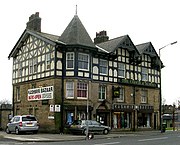 Former Coach and Horses pub, now an Asian clothes shop
 -
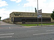 Bowers Group engineering works


Education
Laisterdyke Leadership Academy is located in Thornbury Road,[14] and is the first school in Bradford to be given Business and Enterprise specialist college status.[15] Laisterdyke has a public lending library located off Leeds Road.[16][17]
Transport
The main roads through the area are the A647 Leeds Road, the A6177 Killinghall Road, Laisterdyke Lane, and Sticker Lane and the B6381 Barkerend Road, Coach Row, and Leeds Old Road. Laisterdyke is served by West Yorkshire Metro's, Orange line 606 and 607 bus services.[18]
Sport
Laisterdyke Cricket & Athletic Club have their sports ground and club off Sticker Lane, and are currently home to Northern F.C. of the Bradford Sunday Alliance Football League.[19][20]
Notable residents
The wrestler Les Kellett was born in Laisterdyke.[21] In 1864 Emma Sharp from Laisterdyke completed her famous 1,000 mile walk in Laisterdyke.[22]
See also
- Listed buildings in Bradford (Bradford Moor Ward)
- Laisterdyke Leadership Academy
References
- ^ "Railway pages". John's web pages. Retrieved 15 December 2009.
- ^ "Railway Ramblers Bradford". Lost Railways of West Yorkshire. Archived from the original on 26 August 2009. Retrieved 4 March 2010.; Armour, Chris. "Thackley Station". Subterranea Britannica. Retrieved 4 March 2010.
- ^ a b Gould, Peter. "General History: The Trolleybus in Britain 1911-1972". Local Transport History. Archived from the original on 19 July 2011. Retrieved 2 March 2010.
- ^ "Community Info Provided by Bradford Online". Bradford online. Archived from the original on 17 September 2009. Retrieved 15 December 2009.
- ^ Sutton, Colin (2004). "Bradford - Cinemas of Laisterdyke". Bradford Timeline. Retrieved 29 October 2017.
- ^ "Odeon Leeds-Bradford - Bradford, West Yorkshire". Retrieved 2 October 2013.
- ^ "Laisterdyke Local History Group". Amazon.com. Retrieved 4 March 2010.
- ^ "Pubs in Laisterdyke". Pubs Galore. Retrieved 5 November 2017.
- ^ "Sunday School". British Listed Buildings. Retrieved 5 May 2013.
- ^ "2-34, Mortimer Row". British Listed Buildings. Retrieved 5 May 2013.
- ^ "3-25, Parratt Row". British Listed Buildings. Retrieved 5 May 2013.
- ^ "St Peters Chaplaincy". British Listed Buildings. Retrieved 5 May 2013.
- ^ "Stable Block and Coach House in Yard to Rear of St Peters Chaplaincy". British Listed Buildings. Retrieved 5 May 2013.
- ^ "Laisterdyke Leadership Academy URN: 142681". reports.ofsted.gov.uk. Retrieved 11 January 2020.; Law, Joan. "About the college". Laisterdyke Business+Enterprise College. Archived from the original on 31 August 2010. Retrieved 15 December 2009.; "Laisterdyke Business and Enterprise College". School Index. Retrieved 15 December 2009.[dead link]; "Laisterdyke Business And Enterprise College Bradford". Schools Net. Archived from the original on 1 February 2013. Retrieved 15 December 2009.
- ^ "Laisterdyke Business & Enterprise College.pdf" (PDF). Enterprising Yorkshire. July 2008. Archived from the original (PDF) on 3 March 2012. Retrieved 15 December 2009.
- ^ "Library & Information Services, Laisterdyke Library". Bradford Metropolitan District Council. 2009. Retrieved 15 December 2009.
- ^ "Laisterdyke Library". lib - web - cats. Retrieved 15 December 2009.
- ^ "Bus timetables: Services 600 to 699". Metro. Archived from the original on 2 October 2013. Retrieved 2 March 2010.
- ^ "Laisterdyke Cricket Club". Play-Cricket. Archived from the original on 31 January 2013. Retrieved 15 December 2009.
- ^ "Laisterdyke Cricket Club". Laisterdyke Cricket Club. Retrieved 10 August 2018.
- ^ "Farewell to Lord of the Ring". Bradford Telegraph and Argus. 11 January 2002. Retrieved 23 March 2017.
- ^ Barnett, David (29 May 2009). "Long walk to put women on the map". Bradford Telegraph and Argus.
External links
Wikimedia Commons has media related to Laisterdyke.
- Industry and commerce: Thorite.
Places adjacent to Laisterdyke | ||||||||||||||||
|---|---|---|---|---|---|---|---|---|---|---|---|---|---|---|---|---|
| ||||||||||||||||


Authority control databases | |
|---|---|
| International |
|
| National |
|


