L postcode area
Postcode area within the United Kingdom
53°26′35″N 2°55′34″W / 53.443°N 2.926°W / 53.443; -2.926
L
Liverpool
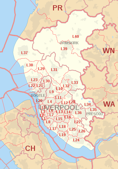
The L postcode area, also known as the Liverpool postcode area,[2] is a group of postcode districts in North West England. Together they cover central and southern Merseyside, southern West Lancashire, and a small part of north-west Cheshire. Its four post towns are Bootle, Liverpool, Ormskirk, and Prescot.
In 1999 the L postcodes on the Wirral Peninsula (L41 to L49 and L60 to L66) were transferred to the CH postcode area.[3]
Coverage
The approximate coverage of the postcode districts:
| Postcode district | Post town | Coverage | Local authority area(s) |
|---|---|---|---|
| L1 | LIVERPOOL | City centre | Liverpool |
| L2 | LIVERPOOL | City centre | Liverpool |
| L3 | LIVERPOOL | City centre, Everton, Vauxhall | Liverpool |
| L4 | LIVERPOOL | Anfield, Kirkdale, Walton | Liverpool |
| L5 | LIVERPOOL | Anfield, Everton, Kirkdale, Vauxhall | Liverpool |
| L6 | LIVERPOOL | Anfield, city centre, Everton, Fairfield, Kensington, Tuebrook | Liverpool |
| L7 | LIVERPOOL | City centre, Edge Hill, Wavertree, Fairfield, Kensington | Liverpool |
| L8 | LIVERPOOL | City centre, Dingle, Toxteth | Liverpool |
| L9 | LIVERPOOL | Aintree, Fazakerley, Orrell Park, Walton | Liverpool, Metropolitan Borough of Sefton |
| L10 | LIVERPOOL | Aintree, Fazakerley, Kirkby | Sefton, Liverpool, Metropolitan Borough of Knowsley |
| L11 | LIVERPOOL | Clubmoor, Croxteth, Gillmoss, Norris Green | Liverpool |
| L12 | LIVERPOOL | Croxteth, West Derby | Liverpool |
| L13 | LIVERPOOL | Clubmoor, Old Swan, Stoneycroft, Tuebrook | Liverpool |
| L14 | LIVERPOOL | Broadgreen, Dovecot, Knotty Ash, Page Moss | Liverpool, Knowsley |
| L15 | LIVERPOOL | Wavertree | Liverpool |
| L16 | LIVERPOOL | Broadgreen, Bowring Park, Childwall | Liverpool, Knowsley |
| L17 | LIVERPOOL | Aigburth, St Michael's Hamlet, Sefton Park | Liverpool |
| L18 | LIVERPOOL | Allerton, Mossley Hill | Liverpool |
| L19 | LIVERPOOL | Aigburth, Garston, Grassendale | Liverpool |
| L20 | BOOTLE | Bootle, Orrell | Sefton |
| LIVERPOOL | Kirkdale | Liverpool | |
| L21 | LIVERPOOL | Ford, Litherland, Seaforth | Sefton |
| L22 | LIVERPOOL | Waterloo | Sefton |
| L23 | LIVERPOOL | Blundellsands, Brighton-le-Sands, Crosby, Little Crosby, Thornton | Sefton |
| L24 | LIVERPOOL | Hale, Speke | Halton, Liverpool |
| L25 | LIVERPOOL | Belle Vale, Gateacre, Halewood, Hunts Cross, Woolton | Liverpool, Knowsley |
| L26 | LIVERPOOL | Halewood | Liverpool, Knowsley |
| L27 | LIVERPOOL | Netherley | Liverpool |
| L28 | LIVERPOOL | Stockbridge Village | Liverpool, Knowsley |
| L29 | LIVERPOOL | Lunt, Sefton | Sefton |
| L30 | BOOTLE | Bootle, Netherton | Sefton |
| L31 | LIVERPOOL | Lydiate, Maghull, Melling, Waddicar | Sefton |
| L32 | LIVERPOOL | Kirkby | Knowsley |
| L33 | LIVERPOOL | Kirkby | Knowsley |
| L34 | PRESCOT | Knowsley, Prescot | Knowsley |
| L35 | PRESCOT | Prescot, Rainhill, Whiston | Knowsley |
| L36 | LIVERPOOL | Huyton, Roby, Tarbock | Knowsley |
| L37 | LIVERPOOL | Formby, Great Altcar, Little Altcar | Sefton, West Lancashire |
| L38 | LIVERPOOL | Hightown, Ince Blundell | Sefton, West Lancashire |
| L39 | ORMSKIRK | Aughton, Ormskirk | West Lancashire |
| L40 | ORMSKIRK | Burscough, Holmeswood, Mawdesley, Scarisbrick, Rufford | West Lancashire, Chorley |
| L67 | LIVERPOOL | Littlewoods Pools[4] | non-geographic |
| L68 | LIVERPOOL | Vernons Pools[4] | non-geographic |
| L69 | LIVERPOOL | PO boxes in central Liverpool, government departments in Liverpool and Bootle, the University of Liverpool[4] | non-geographic |
| L70 | LIVERPOOL | Seasonal response mail[4] | non-geographic |
| L71 | LIVERPOOL | American Express[4] | non-geographic |
| L72 | LIVERPOOL | Shop Direct[4] | non-geographic |
| L73 | LIVERPOOL | BT Group, large Selectapost users[4] | non-geographic |
| L74 | LIVERPOOL | HM Revenue and Customs (Customs and Excise)[4] | non-geographic |
| L75 | LIVERPOOL | HM Revenue and Customs (Inland Revenue)[4] | non-geographic |
| L80 | BOOTLE | non-geographic[5] |
Map
KML file (edit • help)
Template:Attached KML/L postcode area
KML is from Wikidata
See also
References
- ^ "ONS Postcode Directory Version Notes" (ZIP). National Statistics Postcode Products. Office for National Statistics. May 2020. Table 2. Retrieved 19 June 2020. Coordinates from mean of unit postcode points, "Code-Point Open". OS OpenData. Ordnance Survey. February 2012. Retrieved 21 April 2012.
- ^ Royal Mail, Address Management Guide, (2004)
- ^ "Why we are changing postcodes - Royal Mail". Wirral Globe. 18 March 1999. Archived from the original on 7 December 2008. Retrieved 7 December 2008.
- ^ a b c d e f g h i "Non Geographic Codes" (PDF). Royal Mail Address Management Unit. July 2012. Archived from the original (PDF) on 16 September 2012. Retrieved 25 September 2012.
- ^ "Postcode Update 54" (PDF). Royal Mail Address Management Unit. March 2012. Archived from the original (PDF) on 16 August 2012. Retrieved 25 September 2012.
External links
- Royal Mail's Postcode Address File
- A quick introduction to Royal Mail's Postcode Address File (PAF)
- Photographing Every Street in the Liverpool Postal Area
- v
- t
- e
- AB
- AL
- B
- BA
- BB
- BD
- BH
- BL
- BN
- BR
- BS
- BT
- CA
- CB
- CF
- CH
- CM
- CO
- CR
- CT
- CV
- CW
- DA
- DD
- DE
- DG
- DH
- DL
- DN
- DT
- DY
- E
- EC
- EH
- EN
- EX
- FK
- FY
- G
- GL
- GU
- HA
- HD
- HG
- HP
- HR
- HS
- HU
- HX
- IG
- IP
- IV
- KA
- KT
- KW
- KY
- L
- LA
- LD
- LE
- LL
- LN
- LS
- LU
- M
- ME
- MK
- ML
- N
- NE
- NG
- NN
- NP
- NR
- NW
- OL
- OX
- PA
- PE
- PH
- PL
- PO
- PR
- RG
- RH
- RM
- S
- SA
- SE
- SG
- SK
- SL
- SM
- SN
- SO
- SP
- SR
- SS
- ST
- SW
- SY
- TA
- TD
- TF
- TN
- TQ
- TR
- TS
- TW
- UB
- W
- WA
- WC
- WD
- WF
- WN
- WR
- WS
- WV
- YO
- ZE
- Related UK lists: Postcode districts
- Post towns
- Postal counties
- London postal district


