Kullorsuaq Island
Island in Greenland
74°36′N 57°08′W / 74.600°N 57.133°W / 74.600; -57.133Greenland
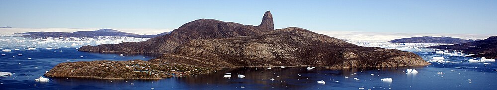
Kullorsuaq Island (old spelling: Kuvdlorssuaq) is an island in the Avannaata municipality in northwestern Greenland. The name of the island means "a big thumb" in the Greenlandic language.
Geography
Part of the Upernavik Archipelago, Kullorsuaq Island is located in the southern part of Melville Bay, to the north of the much larger Kiatassuaq Island, and to the northwest of the mouth of Saqqarlersuup Sullua strait. A small Ikerasaa strait separates the island from the uninhabited Saqqarlersuaq Island in the east.[1]
Devil's Thumb
The island is rocky throughout, with a large landmark pinnacle occupying its center, the 546 m (1,791 ft) Devil's Thumb, from which the island derives its name.[1]
Settlement

Home to the Kullorsuaq settlement, the island is one of the few inhabited islands in the Upernavik Archipelago, and the only such island in its northern part. The closest settlements are Nuussuaq, 53 km (33 mi) to the south, and Savissivik, 274 km (170 mi) to the northwest, on the other end of Melville Bay.
See also
- Melville Monument (Greenland)
References
Wikimedia Commons has media related to Kullorsuaq Island.
- ^ a b Upernavik Avannarleq, Saga Map, Tage Schjøtt, 1992
- v
- t
- e
- Alison
- Baffin
- Inussulik
- Melville
- Qeqertaussap Iterlaa
- Sugar Loaf
- Tasiusaq
- Eqalugaarsuit
- Kangerluarsuk
- Kangerlussuaq (Kangeq Peninsula)
- Kangerlussuaq Icefjord
- Nasaussap Saqqaa
- Nuussuup Kangia
- Saqqarsuaq
- Sullua
- Upernavik Icefjord
- Alanngorsuup Sermia
- Cornell
- Giesecke
- Hayes
- Illullip Sermia
- Kjer
- Nunatakassaup Sermia
- Nunatakassaup Sermia (Tasiusaq Bay)
- Upernavik
| Melville Bay |
|
|---|---|
| Inussulik Bay | |
| Sugar Loaf Bay |
|
| Tasiusaq Bay |
|
| Baffin Bay |
|
- Akullikassaq
- Anoritooq
- Devil's Thumb
- Inalugartuut
- Inngik
- Iviannernat
- Kangerluarsuup Qaqqarsua
- Kingittoq
- Kissavaussaq
- Kunngutip Qaqqaa
- Naajannguaq
- Naalungiussaq
- Najaarsuit Qaqqat
- Niaqornarsuaq
- Nunatakassak
- Nunatarsuaq
- Nunatarsuaq (Tasiusaq Bay)
- Nuniaat Qaqqarsua
- Orsugissap Qaqqarsua
- Paatuup Qaqqaa
- Qaqqasunnarsuaq
- Qassersuit
- Saattup Akia
- Sandersons Hope
- Toornaarsuttoq
- Tunullersuaq
- Tuttulikassak
- Umiasussuk
- Wandel Land


