Kampot Municipality
Municipality in Kampot, Cambodia
Kampot Municipality ក្រុងកំពត Krong Kampot | |
|---|---|
 Khum Traeuy Kaoh | |
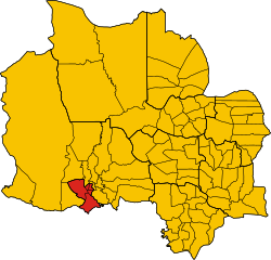 Municipality location in Kampot Province | |
| Coordinates: 10°36′N 104°10′E / 10.600°N 104.167°E / 10.600; 104.167 | |
| Country |  Cambodia Cambodia |
| Province | Kampot |
| Quarters | 5 |
| Villages | 15 |
| Government | |
| • Type | City-municipality |
| • Mayor | Neak Sovannary |
| Population (2008)[1] | |
| • Total | 36,367 |
| Time zone | UTC+7 (ICT) |
| Geocode | 0708 |
| Website | kampot |

This article contains Khmer text. Without proper rendering support, you may see question marks, boxes, or other symbols instead of Khmer script.
The Kampot Municipality (Khmer: ក្រុងកំពត) is a municipality in Kampot Province, in southern Cambodia.[2] The provincial capital Kampot is located within the municipality.
Communes and villages
| Sangkat (Quarters) | Phum (Villages) |
|---|---|
| Kampong Kandal | Sovann Sakor, Phum Muoy Ousaphie |
| Krang Ampil | Krang, Svay Thum |
| Kampong Bay | Kampong Bay Khang Cheung, Kampong Bay Khang Tboung, Bakoeng |
| Andoung Khmer | Tvi Khang Cheung, Tvi Khang Tboung, Ou Touch, Andoung Khmaer, Ta Deb |
| Traeuy Kaoh | Doun Taok, Ta Angk, Boeng Ta Pream, Srae |
References
- v
- t
- e
Kampot provinceCapital: Kampot
- Angkor Chey
- Banteay Meas
- Chhouk
- Chum Kiri
- Dang Tong
- Kampong Trach
- Kampot Municipality
- city
- Tuek Chhou

| |||
|---|---|---|---|
| Autonomous municipality |
| ||
| Provinces | |||
| Authority control databases |
|
|---|
10°36′N 104°10′E / 10.600°N 104.167°E / 10.600; 104.167
 | This Cambodian location article is a stub. You can help Wikipedia by expanding it. |
- v
- t
- e


