Kōnan, Tokyo
District in Kantō, Japan
Kōnan 35°37′53.12″N 139°45′1.77″E / 35.6314222°N 139.7504917°E / 35.6314222; 139.7504917 | |
|---|---|
| Country | Japan |
| Region | Kantō |
| Prefecture | Tokyo |
| Ward | Minato |
| Area | |
| • Total | 2.19 km2 (0.85 sq mi) |
| Population (August 1, 2019)[2] | |
| • Total | 20,819 |
| • Density | 9,500/km2 (25,000/sq mi) |
| Time zone | UTC+9 (JST) |
| Zip code | 108-0075 |
| Area code | 03 |
Kōnan (港南) is a district of Minato, Tokyo, Japan. The current administrative place names are Konan 1-chome to Konan 5-chome. It is within the Shibaura-Kōnan District General Branch of the Japan Post Service.
Education
Minato City Board of Education operates public elementary and junior high schools.
Kōnan 1-5 chōme are zoned to Kōnan Elementary School (港南小学校) and Kōnan Junior High School (港南中学校).[3]
-
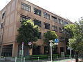 Kōnan Junior High School (港南中学校)
 -
 Kōnan Elementary School (港南小学校)


References
External links
 Tokyo portal

Wikimedia Commons has media related to Konan, Minato.
- v
- t
- e
 Minato, Tokyo
| Shiba Area |
|
|---|---|
| Azabu Area | |
| Akasaka Area | |
| Takanawa Area |
|
| Shibaura-Kōnan Area |

- Akasaka-mitsuke (Metro)
- Aoyama-itchōme (Metro, Toei)
- Azabu-Jūban (Metro, Toei)
- Hamamatsuchō/Daimon (JR, Toei, Monorail)
- Omote-sandō (Metro)
- Roppongi (Metro, Toei)
- Shimbashi (JR, Metro, Toei, Yurikamome)
- Shinagawa (JR, Shinkansen, Keikyu)
- Takanawa Gateway/Sengakuji (JR, Toei, Keikyu)
- Tamachi/Mita (JR, Toei)
- Tameike-Sannō (Metro)
| Tertiary |
|
|---|---|
| Public K-12 |
|
| Private K-12 |
|
* - formerly part of Shiba Area
| Authority control databases: Geographic |
|
|---|


