Jericho Trail
Hiking trail in Connecticut, US
| Jericho Trail | |
|---|---|
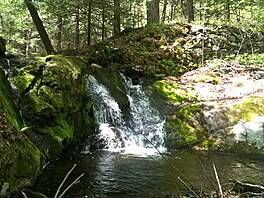 Jericho Brook water falls over ancient broken dam into pool below. | |
| Length | 3.4 miles (5.5 km)[1] |
| Location | Mattatuck State Forest, Watertown (near Thomaston and Plymouth), Litchfield County, Connecticut |
| Designation | CFPA Blue-Blazed Trail |
| Use | hiking, cross-country skiing, snowshoeing, fishing, rock climbing, geocaching |
| Highest point | Crane's Lookout, 810 ft (250 m) |
| Difficulty | Easy to moderate difficulty, some rock scrambling. |
| Sights | Naugatuck River Valley, White stone cliffs, Rock House, Crane's Lookout. |
| Hazards | hunters, deer ticks, poison ivy |
The Jericho trail is a 3.4-mile (5.5 km) Blue-Blazed hiking trail in Watertown, near the border with Thomaston and Plymouth, Litchfield County, Connecticut. The trail is contained almost entirely in a section of the Mattatuck State Forest. The mainline trail is a linear north–south "hike-through" trail.
The trail is listed as one of the three short Waterbury Area Trails in the Connecticut Walk Book West.
The Jericho trail is a linear trail with a trailhead and parking area at the trails southern terminus on Echo Lake Road and a connector trail leading to Connecticut Route 262 in the west. The northern terminus terminates at the trail's intersection with the Mattatuck Trail near the Rock House and Crane's Lookout. Notable features several scenic overlook views including an 810-foot summit with a 270 degree panorama (Crane's Lookout 41°37′45″N 73°03′23″W / 41.6293°N 73.0565°W / 41.6293; -73.0565). The trail stops just before Crane's Lookout and the Rock House underneath, both which are on the Mattatuck Trail.[2] The trail is maintained largely through the efforts of the Connecticut Forest and Park Association.
Trail description

The Jericho Trail is primarily used for hiking, backpacking, rock climbing,[3] and in the winter, snowshoeing.
Trail route
From the north it is also possible to connect to the Jericho Trail via the Mattatuck Trail (which can be found in Black Rock State Park), or to hike in using either of two unmarked paths (which include dirt road portions), one off of Park Road the other on.[4]

Origin and name
The trail is named for Jericho Brook which the trail follows for a length of less than a mile in the upper northern half of the trail route.[1]
Folklore
The Leatherman was a nineteenth-century vagabond who traveled approximately ten miles a day in a thirty-four (34) day circular route between New York's Hudson River in the west and the Connecticut River in the east. His circuit was also bounded by Long Island Sound in the South and the Litchfield Hills in the north.[4]
He was found dead in March 1889 near Ossining, New York, in his Saw Mill Woods rock shelter (apparently of mouth cancer due to his use of tobacco) and is buried at the Sparta Cemetery, Route 9, Scarborough, New York.[5]
Hiking
The mainline trail is blazed with blue rectangles. Trail descriptions are available from a number of commercial and non-commercial sources, and a complete guidebook is published by the Connecticut Forest and Park Association in the Connecticut Walk Book west. A map of the Thomaston and Watertown sections of the trail is available from the Connecticut Department of Energy and Environmental Protection at its website.[6]
Weather along the route is typical of Connecticut. Conditions on exposed ridge tops and summits may be harsher during cold or stormy weather.[7]
See also
- Blue-Blazed Trails
- Leatherman (vagabond)
- Mattatuck State Forest
- Naugatuck Railroad
- Naugatuck River
- Watertown
References
- ^ a b Colson, Ann T. (2006). Connecticut Walk Book West (19th ed.). Connecticut Forest and Park Association. ISBN 0-9619052-6-3.
- ^ Connecticut Walk Book: A Trail Guide to the Connecticut Outdoors. 17th Edition. The Connecticut Forest and Park Association. Rockfall, Connecticut. Undated.
- ^ "Outdoor rock climbing at Whitestone Cliff Plymouth CT & Whitestone climbing partners - Climbfind.com". Archived from the original on 2009-07-08. Retrieved 2010-05-29.
- ^ a b Department of Environmental Protection (2011-11-08). "DEEP: Letterboxing Clues for Mattatack State Forest". ct.gov. Retrieved 31 May 2016.
- ^ Research by Dan W. DeLuca Archived 2006-12-06 at the Wayback Machine (retrieved July 21, 2006)
- ^ "Mattatuck State Forest: Thomaston and Waterbury". Conn. Dept. of Energy and Environmental Protection. Retrieved 6 December 2011.
- ^ "National Weather Service | NOAA". weather.gov. Retrieved 31 May 2016.
Further reading
Books – Connecticut hiking [edit]
- Colson, Ann T. (2005). Connecticut Walk Book East (19 ed.). Rockfall, Connecticut: Connecticut Forest and Park Association. pp. 1–261. ISBN 0961905255.
- Colson, Ann T. (2006). Connecticut Walk Book West (19 ed.). Rockfall, Connecticut: Connecticut Forest and Park Association. pp. 1–353. ISBN 0961905263.
- Emblidge, David (1998). Hikes in southern New England: Connecticut, Massachusetts, Vermont (1 ed.). Mechanicsburg, Pennsylvania: Stackpole Books. pp. 1–304. ISBN 0-8117-2669-X.
- Keyarts, Eugene (2002). Pietrzyk, Cindi Dale (ed.). Short Nature Walks: Connecticut Guide Book (7 ed.). Guilford, Connecticut: Falcon Publishing. pp. 1–192. ISBN 0-7627-2310-6.
- Laubach, Rene; Smith, Charles W. G. (2007). AMC's Best Day Hikes in Connecticut (1 ed.). Guilford, Connecticut: Appalachian Mountain Club Books. pp. 1–320. ISBN 1-934028-10-X.
- Ostertag, Rhonda; Ostertag, George (2002). Hiking Southern New England (2 ed.). Guilford, Connecticut: Falcon Publishing. pp. 1–336. ISBN 0-7627-2246-0.
Books – Connecticut history and geography [edit]
- De Forest, John (1853). History of the Indians of Connecticut from the earliest known period to 1850. Hartford, Connecticut: Wm. Jas. Hamersley. pp. 1–509.
- Hayward, John (1857). New England Gazetteer: Containing Descriptions of the States, Counties, Cities and Towns of New England (2 ed.). Boston, Massachusetts: Otis Clapp. pp. 1–704.
- Trumbull, Benjamin (1797). A Complete History of Connecticut - Civil and Ecclesiastical. Vol. I (1818 printing ed.). New Haven, Connecticut: Maltby, Goldsmith & Co. and Samuel Wadsworth. pp. 1–1166.
- Trumbull, Benjamin (1797). A Complete History of Connecticut - Civil and Ecclesiastical. Vol. II (1818 printing ed.). New Haven, Connecticut: Maltby, Goldsmith & Co. and Samuel Wadsworth. pp. 1–1166.
External links
Specific to this trail:
- CT Museum Quest Article on the Jericho Trail
- CT Museum Quest Article on the Whitestone-Jericho Connector
Government Links:
- State of Connecticut Department of Energy and Environmental Protection page for the Mattatuck State Forest, including a map
- State of Connecticut Department of Environmental Protection Forestry Division Letterboxing Clues for Mattatuck State Forest
- Town of Watertown Website
Leatherman:
- The Legend of the Old Leatherman
- Cold Spots: The Legend of the Leatherman
- v
- t
- e
- Airline
- Alain and May White
- American Legion
- Appalachian
- Arthur A. Harris
- Aspetuck Valley
- Bigelow Hollow
- Case Mountain
- Charter Oak Greenway
- Chatfield
- Cockaponset
- East Coast Greenway
- Falls Brook
- Farmington Canal Heritage
- Gay City
- Hancock Brook
- Hop River
- Housatonic Range
- Iron
- Jericho
- Kettletown
- Lillinonah
- Lone Pine
- Macedonia Brook
- Mattabesett
- Mattatuck
- McLean Game Refuge
- Menunkatuck
- Metacomet
- Mohawk
- Moosup Valley
- Muir
- Narragansett
- Natchaug
- Naugatuck
- Nayantaquit
- Nehantic
- New England
- Nipmuck
- Old Furnace
- Pachaug
- Paugussett
- Peoples
- Pequot
- Pine Knob
- Pomperaug
- Quinebaug
- Quinnipiac
- Ragged Mountain
- Regicides
- Salmon River
- Saugatuck
- Shenipsit
- Sleeping Giant
- Still River Greenway
- Stony Creek Quarry
- Sunny Valley Preserve
- Tunxis
- Washington–Rochambeau Revolutionary Route
- Westwoods
- Whitestone Cliffs
- Williams
- Wolcott
- Zoar


