Japan National Route 189
Road in Yamaguchi prefecture, Japan
You can help expand this article with text translated from the corresponding article in Japanese. (December 2021) Click [show] for important translation instructions.
- Machine translation, like DeepL or Google Translate, is a useful starting point for translations, but translators must revise errors as necessary and confirm that the translation is accurate, rather than simply copy-pasting machine-translated text into the English Wikipedia.
- Consider adding a topic to this template: there are already 3,678 articles in the main category, and specifying
|topic=will aid in categorization. - Do not translate text that appears unreliable or low-quality. If possible, verify the text with references provided in the foreign-language article.
- You must provide copyright attribution in the edit summary accompanying your translation by providing an interlanguage link to the source of your translation. A model attribution edit summary is
Content in this edit is translated from the existing Japanese Wikipedia article at [[:ja:国道189号]]; see its history for attribution. - You may also add the template
{{Translated|ja|国道189号}}to the talk page. - For more guidance, see Wikipedia:Translation.
 | ||||
|---|---|---|---|---|
| 国道189号 | ||||
 | ||||
 | ||||
| Route information | ||||
| Length | 0.4 km[1] (0.25 mi; 1,300 ft) | |||
| Existed | 1953–present | |||
| Major junctions | ||||
| East end | Marine Corps Air Station Iwakuni | |||
| West end |  National Route 188 in Iwakuni, Yamaguchi National Route 188 in Iwakuni, Yamaguchi | |||
| Location | ||||
| Country | Japan | |||
| Highway system | ||||
| ||||
| ||||


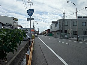
National Route 189 is a national highway of Japan in Iwakuni, Yamaguchi, connecting Marine Corps Air Station Iwakuni and Japan National Route 2, with a total length of 0.4 km (0.25 mi).[Note 1]
Overview
Route 189 connects with the main gate of Marine Corps Air Station Iwakuni at the southernmost end, and with the Taiteishi intersection of Routes 2 and 188. Access to the commercial portion of Air Station Iwakuni is provided by the Yamaguchi Prefectural Route 110 Iwakuni Kintaikyo Airport Line.[2]
While the actual length of the road is 2.9 km (1.80 mi), over 2.5 km (1.55 mi) of this overlaps with Japan National Route 188. The section of this route with no overlap is just 372 m (1,220.5 ft) long, making it the second-shortest national highway in Japan, longer than Route 174 by 185 m (607.0 ft), and shorter than Route 130 by 110 m (360.9 ft).[3]
Intersecting roads
| Intersecting roads | Intersects to | |
|---|---|---|
| Japan National Route 188 Overlapping section start | Kurumacho | Iwakuni Airport Entrance Intersection |
| Japan National Route 2 Japan National Route 187 Japan National Route 188 Overlapping section end | Japan National Route 188 | Tateishi Intersection/End of Route |
Route Data
Start and end points are as designated by ordinance.[4]
- Start: Iwakuni Airport
- End: 1-Chome, Marifu, Iwakuni City
- Length: 0.4 km (0.25 mi)
History
Route 189 was opened in 1953, first designated as a second class national highway named Second-class National Route 189 Iwakuni Airport Line.[5] At that time, Iwakuni Airport and Haneda Airport were the only two international airports in western Japan, making this an important road.[6] As US military presence increased, gradually civilian aircraft were not allowed at the airport, until in 1967 civilian operations ceased.[6]
Until 2010 the official end-point of Route 189 lay within the US military base at Iwakuni, causing road management and maintenance issues as the general public have no access. This was due to the original designation stating that the road ended before the platform where the national flag was hoisted, inside the main gate.[7] In 2010 this was changed, with the road now officially ending at the main gate of the base.[8]
In 2012 civilian operations from Iwakuni airport began once again with the construction of the Iwakuni Kintaikyo Airport terminal. Despite this, Route 189 remains unchanged, leaving it useless for civilians wishing to use the airport,[9] who instead use Yamaguchi Prefectural Route 110.
See also
 Japan portal
 Roads portal


Notes
- ^ In the 2013 road statistics report, it had a stated length of 2.9 km, but in the 2014 road statistics report, it had been shortened to 0.4 km.
References
- ^ "一般国道の路線別、都道府県別道路現況" [Road statistics by General National Highway route and prefecture] (PDF) (in Japanese). Ministry of Land, Infrastructure, Transport and Tourism. Retrieved 18 February 2020.
- ^ "山口県報 第2344号" (PDF) (in Japanese). Yamaguchi Prefectural Bulletin. 2012-03-03. Archived from the original (PDF) on 2021-07-07. Retrieved 2022-08-23.
- ^ "日本の国道と浜通りの国道の比較" (in Japanese). Iwaki National Highway Office. Retrieved 2022-08-23.
- ^ "一般国道の路線を指定する政令". 2015-08-01. Retrieved 2022-08-23.
- ^ 二級国道の路線を指定する政令 (昭和二十八年) (in Japanese) – via Wikisource.
- ^ a b 佐藤健太郎 (2015). 国道者 (in Japanese). Shinchosha. p. 167. ISBN 978-4-10-339731-1.
- ^ 佐藤健太郎 (2015). 国道者 (in Japanese). Shinchosha. p. 166. ISBN 978-4-10-339731-1.
- ^ 佐藤健太郎 (2015). 国道者 (in Japanese). Shinchosha. pp. 167–168. ISBN 978-4-10-339731-1.
- ^ 佐藤健太郎 (2015). 国道者 (in Japanese). Shinchosha. p. 168. ISBN 978-4-10-339731-1.
Wikimedia Commons has media related to Route 189 (Japan).
- v
- t
- e
 National highways of Japan
- 101
- 102
- 103
- 104
- 105
- 106
- 107
- 108
- 109
- 110
- 111
- 112
- 113
- 114
- 115
- 116
- 117
- 118
- 119
- 120
- 121
- 122
- 123
- 124
- 125
- 126
- 127
- 128
- 129
- 130
- 131
- 132
- 133
- 134
- 135
- 136
- 137
- 138
- 139
- 140
- 141
- 142
- 143
- 144
- 145
- 146
- 147
- 148
- 149
- 150
- 151
- 152
- 153
- 154
- 155
- 156
- 157
- 158
- 159
- 160
- 161
- 162
- 163
- 164
- 165
- 166
- 167
- 168
- 169
- 170
- 171
- 172
- 173
- 174
- 175
- 176
- 177
- 178
- 179
- 180
- 181
- 182
- 183
- 184
- 185
- 186
- 187
- 188
- 189
- 190
- 191
- 192
- 193
- 194
- 195
- 196
- 197
- 198
- 199
- 200
- 201
- 202
- 203
- 204
- 205
- 206
- 207
- 208
- 209
- 210
- 211
- 212
- 213
- 214
- 215
- 216
- 217
- 218
- 219
- 220
- 221
- 222
- 223
- 224
- 225
- 226
- 227
- 228
- 229
- 230
- 231
- 232
- 233
- 234
- 235
- 236
- 237
- 238
- 239
- 240
- 241
- 242
- 243
- 244
- 245
- 246
- 247
- 248
- 249
- 250
- 251
- 252
- 253
- 254
- 255
- 256
- 257
- 258
- 259
- 260
- 261
- 262
- 263
- 264
- 265
- 266
- 267
- 268
- 269
- 270
- 271
- 272
- 273
- 274
- 275
- 276
- 277
- 278
- 279
- 280
- 281
- 282
- 283
- 284
- 285
- 286
- 287
- 288
- 289
- 290
- 291
- 292
- 293
- 294
- 295
- 296
- 297
- 298
- 299
- 300
- 301
- 302
- 303
- 304
- 305
- 306
- 307
- 308
- 309
- 310
- 311
- 312
- 313
- 314
- 315
- 316
- 317
- 318
- 319
- 320
- 321
- 322
- 323
- 324
- 325
- 326
- 327
- 328
- 329
- 330
- 331
- 332
- 333
- 334
- 335
- 336
- 337
- 338
- 339
- 340
- 341
- 342
- 343
- 344
- 345
- 346
- 347
- 348
- 349
- 350
- 351
- 352
- 353
- 354
- 355
- 356
- 357
- 358
- 359
- 360
- 361
- 362
- 363
- 364
- 365
- 366
- 367
- 368
- 369
- 370
- 371
- 372
- 373
- 374
- 375
- 376
- 377
- 378
- 379
- 380
- 381
- 382
- 383
- 384
- 385
- 386
- 387
- 388
- 389
- 390
- 391
- 392
- 393
- 394
- 395
- 396
- 397
- 398
- 399
- 400
- 401
- 402
- 403
- 404
- 405
- 406
- 407
- 408
- 409
- 410
- 411
- 412
- 413
- 414
- 415
- 416
- 417
- 418
- 419
- 420
- 421
- 422
- 423
- 424
- 425
- 426
- 427
- 428
- 429
- 430
- 431
- 432
- 433
- 434
- 435
- 436
- 437
- 438
- 439
- 440
- 441
- 442
- 443
- 444
- 445
- 446
- 447
- 448
- 449
- 450
- 451
- 452
- 453
- 454
- 455
- 456
- 457
- 458
- 459
- 460
- 461
- 462
- 463
- 464
- 465
- 466
- 467
- 468
- 469
- 470
- 471
- 472
- 473
- 474
- 475
- 476
- 477
- 478
- 479
- 480
- 481
- 482
- 483
- 484
- 485
- 486
- 487
- 488
- 489
- 490
- 491
- 492
- 493
- 494
- 495
- 496
- 497
- 498
- 499
- 500
- 501
- 502
- 503
- 504
- 505
- 506
- 507
Route numbers in italics are no longer in use.
 Category
 Category
 | This article relating to the roads and highways in Japan is a stub. You can help Wikipedia by expanding it. |
- v
- t
- e


