Huveaune
River in France


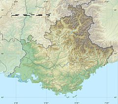
• location
• coordinates
The Huveaune (French pronunciation: [yvon]; Occitan: Evèuna) is a small river in the Provence-Alpes-Côte d'Azur region of southeastern France. It is 48.5 kilometres (30.1 mi) long and flows through the communes of La Penne-sur-Huveaune, Nans-les-Pins, Saint-Zacharie, Plan-d'Aups-Sainte-Baume, Auriol, Roquevaire, Aubagne, and the metropolitan area of Marseille.[1]
The Huveaune rises in the Castelette cave at 590 metres (1,940 ft) in the Sainte-Baume mountain range, and runs into the Mediterranean Sea at Marseille. Its drainage basin is 502 km2 (194 sq mi).[2]


References
Wikimedia Commons has media related to Huveaune.
- v
- t
- e

- Marseille Provence Airport
- Train network and stations
- Bus
- Metro
- Navette maritime
- RTM
- Tramway
- Le vélo sharing bikes system
- Highways network (A7
- A50
- A55
- L2
- Major/la Joliette tunnel
- Vieux-Port de Marseille tunnel
- Prado-Carénage tunnel)
- Abbey of St Victor
- Bastide de la Guillermy
- Belsunce
- Bompard
- Calanques National Park
- Canebière
- Château Borély
- Château d'If
- Château Pastré
- Cimetière Saint-Pierre
- CMA CGM Tower
- Docks
- Église Notre-Dame-du-Mont
- Église Saint Roch
- Église Saint-Vincent-de-Paul
- Marseille-Blancarde station
- Marseille-Saint-Charles station
- Grande Synagogue
- Hippodrome de Marseille
- Hôtel-Dieu de Marseille
- L'Estaque
- La Friche
- La Joliette
- La Treille
- Ledge of President John Fitzgerald Kennedy
- Marseille Cathedral
- Marseille-Fos Port
- Marseille History Museum
- Mazargues
- Musée Cantini
- Musée Grobet-Labadié
- Muséum d'histoire naturelle de Marseille
- Museum of European and Mediterranean Civilisations
- Museum of the Decorative Arts, Fashion and Ceramics
- Notre-Dame de la Garde
- Opéra
- Oppidum de Verduron
- Palais de la Bourse
- Palais du Pharo
- Palais Longchamp
- Parc Borély
- Parc du 26e Centenaire
- Place Castellane
- Place Jean-Jaurès
- Plages du Prado
- Porte d'Aix
- Stade Vélodrome
- Thiers
- Unité d'habitation
- Vallon des Auffes
- Vieille Charité
- Vieux-Port
- Villa Valmer
Authority control databases | |
|---|---|
| International |
|
| National |
|
 | This Bouches-du-Rhône geographical article is a stub. You can help Wikipedia by expanding it. |
- v
- t
- e
This article related to a river in France is a stub. You can help Wikipedia by expanding it. |
- v
- t
- e


