Grade I and II* listed buildings in the Royal Borough of Kingston upon Thames
Map all coordinates using OpenStreetMap
Download coordinates as:
- KML
- GPX (all coordinates)
- GPX (primary coordinates)
- GPX (secondary coordinates)
There are over 9,000 Grade I listed buildings and 20,000 Grade II* listed buildings in England. This page is a list of these buildings in the Royal Borough of Kingston upon Thames.
Grade I
| Name | Location | Type | Completed [note 1] | Date designated | Grid ref.[note 2] Geo-coordinates | Entry number [note 3] | Image |
|---|---|---|---|---|---|---|---|
| Church of All Saints | Kingston upon Thames | Church | Norman | 30 July 1951 | TQ1790369300 51°24′38″N 0°18′22″W / 51.410474°N 0.306125°W / 51.410474; -0.306125 (Church of All Saints) | 1358437 | 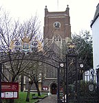 More images |
| Clattern Bridge | Kingston upon Thames | Bridge | 12th century with later alterations | 30 July 1951 | TQ1786169094 51°24′31″N 0°18′24″W / 51.408631°N 0.306797°W / 51.408631; -0.306797 (Clattern Bridge) | 1080064 |  More images |
| Coronation Stone | Kingston upon Thames | Balustrade | Mid 19th century | 6 October 1983 | TQ1786769069 51°24′30″N 0°18′24″W / 51.408405°N 0.306719°W / 51.408405; -0.306719 (Coronation Stone) | 1080066 |  More images |
Grade II*
| Name | Location | Type | Completed [note 1] | Date designated | Grid ref.[note 2] Geo-coordinates | Entry number [note 3] | Image |
|---|---|---|---|---|---|---|---|
| Chantry Chapel of St Mary Magdalene | Kingston upon Thames | School | 1951 | 30 July 1951 | TQ1857569358 51°24′39″N 0°17′47″W / 51.410855°N 0.296448°W / 51.410855; -0.296448 (Chantry Chapel of St Mary Magdalene) | 1358425 |  More images |
| Church of St Raphael | Kingston upon Thames | Church | 1847-8 | 24 December 1968 | TQ1782368365 51°24′08″N 0°18′27″W / 51.402087°N 0.307585°W / 51.402087; -0.307585 (Church of St Raphael) | 1080045 |  More images |
| Cleave's Almshouses | Kingston upon Thames | Almshouse | 1668 | 30 July 1951 | TQ1847669366 51°24′39″N 0°17′52″W / 51.410948°N 0.297868°W / 51.410948; -0.297868 (Cleave's Almshouses) | 1184584 | 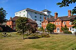 More images |
| Coombe Conduit House | Kingston upon Thames | Tunnel | 1538–1540 | 30 May 1951 | TQ2049469841 51°24′53″N 0°16′07″W / 51.414792°N 0.268705°W / 51.414792; -0.268705 (Coombe Conduit House) | 1080099 |  Upload Photo |
| Druid's Head Public House | Kingston upon Thames | Public House | 17th century | 6 October 1983 | TQ1788369161 51°24′33″N 0°18′23″W / 51.409229°N 0.306458°W / 51.409229; -0.306458 (Druid's Head Public House) | 1184751 |  More images |
| Gallows Conduit House (in Grounds of Hampton Spring) | Kingston upon Thames | Conduit House | 1538–1540 | 30 May 1951 | TQ2004670220 51°25′06″N 0°16′30″W / 51.418294°N 0.275015°W / 51.418294; -0.275015 (Gallows Conduit House (in Grounds of Hampton Spring)) | 1080062 | Upload Photo |
| Kingston Bridge | Kingston upon Thames | Bridge | 1825-8 | 30 July 1951 | TQ1773669370 51°24′40″N 0°18′31″W / 51.411138°N 0.308502°W / 51.411138; -0.308502 (Kingston Bridge) | 1300232 | 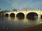 More images |
| Market House | Kingston upon Thames | Building | 1706 | 10 June 1983 | TQ1789569226 51°24′35″N 0°18′23″W / 51.409811°N 0.306264°W / 51.409811; -0.306264 (Market House) | 1358428 |  More images |
| 105 London Road | Kingston upon Thames | Building | Late C17/C18 | 6 October 1983 | TQ1857169361 51°24′39″N 0°17′47″W / 51.410883°N 0.296504°W / 51.410883; -0.296504 (105 London Road) | 1184600 | Upload Photo |
| 37–41 High Street | Kingston upon Thames | House | 16th century | 30 July 1951 | TQ1780268900 51°24′25″N 0°18′28″W / 51.4069°N 0.307709°W / 51.4069; -0.307709 (37–41 High Street) | 1358459 |  More images |
| Picton House | Kingston upon Thames | House | 1740s | 20 February 1970 | TQ1778168961 51°24′27″N 0°18′29″W / 51.407453°N 0.307991°W / 51.407453; -0.307991 (Picton House) | 1080069 | 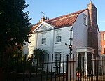 More images |
Notes
- ^ a b The date given is the date used by Historic England as significant for the initial building or that of an important part in the structure's description.
- ^ a b Sometimes known as OSGB36, the grid reference is based on the British national grid reference system used by the Ordnance Survey.
- ^ a b The "List Entry Number" is a unique number assigned to each listed building and scheduled monument by Historic England.
External links
 Media related to Grade I listed buildings in the Royal Borough of Kingston upon Thames at Wikimedia Commons
- Media related to Grade II* listed buildings in the Royal Borough of Kingston upon Thames at Wikimedia Commons
- v
- t
- e


- Kingston and Surbiton
- Richmond Park
- Council
- Grade I and II* listed buildings
- People
- Public art
- Schools
 Category
- Commons

Portals:
 London
 Architecture


