Grade I and II* listed buildings in the London Borough of Tower Hamlets
Map all coordinates using OpenStreetMap
Download coordinates as:
- KML
- GPX (all coordinates)
- GPX (primary coordinates)
- GPX (secondary coordinates)
There are over 9,000 Grade I listed buildings and 20,000 Grade II* listed buildings in England. This page is a list of these buildings in the London Borough of Tower Hamlets.
Grade I
| Name | Location | Type | Completed [note 1] | Date designated | Grid ref.[note 2] Geo-coordinates | Entry number [note 3] | Image |
|---|---|---|---|---|---|---|---|
| Tobacco Dock, including vaults extending under Wapping Lane | Pennington St, London El | Tobacco Warehouse | 1811–13 | 29 December 1950 | TQ3470080589 51°30′29″N 0°03′38″W / 51.508184°N 0.060453°W / 51.508184; -0.060453 (Tobacco Dock, including vaults extending under Wapping Lane) | 1065827 |  More images |
| Blackwall Basin | Tower Hamlets | Dock Basin | 1800–02 | 1 July 1983 | TQ3813080156 51°30′12″N 0°00′40″W / 51.503466°N 0.01123°W / 51.503466; -0.01123 (Blackwall Basin) | 1242449 | 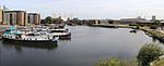 More images |
| Chapel of St Peter Ad Vincula | Tower of London, Tower Hamlets | Parish Church | 1519–20 | 30 November 1989 | TQ3356080598 51°30′31″N 0°04′37″W / 51.508535°N 0.076866°W / 51.508535; -0.076866 (Chapel of St Peter Ad Vincula) | 1357540 | 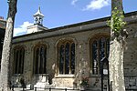 More images |
| Christ Church (including Gatepiers and Gates to Vergers Yard) | Tower Hamlets | Church | 1714–1729 | 29 December 1950 | TQ3374881780 51°31′09″N 0°04′25″W / 51.519113°N 0.073711°W / 51.519113; -0.073711 (Christ Church (including Gatepiers and Gates to Vergers Yard)) | 1357795 | 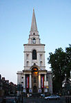 More images |
| Church of St Anne | Limehouse, Tower Hamlets | Church | 1712–30 | 29 December 1950 | TQ3678181033 51°30′42″N 0°01′49″W / 51.511674°N 0.030314°W / 51.511674; -0.030314 (Church of St Anne) | 1357808 |  More images |
| Church of St George in the East | Tower Hamlets | Church | 1729 | 29 December 1950 | TQ3474580797 51°30′36″N 0°03′35″W / 51.510042°N 0.059725°W / 51.510042; -0.059725 (Church of St George in the East) | 1357779 |  More images |
| Church of St John on Bethnal Green | Bethnal Green, Tower Hamlets | Church | 1824–25 | 18 July 1949 | TQ3502782758 51°31′39″N 0°03′18″W / 51.527597°N 0.054913°W / 51.527597; -0.054913 (Church of St John on Bethnal Green) | 1065245 | 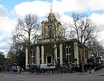 More images |
| St Peter's, London Docks | Wapping Lane, London, E1W 2RW | Anglican Church | 1865–1866 | 29 September 1973 | TQ3486580368 51°30′22″N 0°03′29″W / 51.506159°N 0.058161°W / 51.506159; -0.058161 (St Peter's, London Docks) | 1065844 | 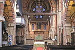 More images |
| Inner Curtain Wall, with Mural Towers, the New Armouries, the Queen's House, Tower Green | Tower Hamlets | House | 1989 | 30 November 1989 | TQ3353880586 51°30′30″N 0°04′38″W / 51.508433°N 0.077187°W / 51.508433; -0.077187 (Inner Curtain Wall, with Mural Towers, the New Armouries, the Queen's House, Tower Green) | 1242062 | 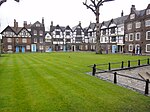 More images |
| Mercantile Marine First World War Memorial | Tower Hill | War memorial | 1928 | 27 September 1973 | TQ3350180710 51°30′35″N 0°04′41″W / 51.509731°N 0.07794°W / 51.509731; -0.07794 (Mercantile Marine First World War Memorial) | 1260087 |  More images |
| Outer Curtain Wall with Casements and Mural Towers | Tower of London, Tower Hamlets | Moat | Late 13th century or early 14th century | 30 November 1989 | TQ3358880649 51°30′32″N 0°04′35″W / 51.508987°N 0.076443°W / 51.508987; -0.076443 (Outer Curtain Wall with Casements and Mural Towers) | 1242026 |  More images |
| Parish Church of St Dunstan and All Saints (the Church of the High Seas) | Stepney, Tower Hamlets | Church | 10th century | 29 December 1950 | TQ3597681586 51°31′01″N 0°02′30″W / 51.516838°N 0.041694°W / 51.516838; -0.041694 (Parish Church of St Dunstan and All Saints (the Church of the High Seas)) | 1065065 |  More images |
| Portion of Old London Wall | Tower Hamlets | Town Wall | Roman | 29 December 1950 | TQ3361380754 51°30′36″N 0°04′34″W / 51.509925°N 0.076044°W / 51.509925; -0.076044 (Portion of Old London Wall) | 1357518 | 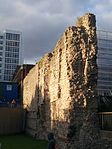 More images |
| Quay Walls, copings and Buttresses to Import Dock and Export Dock | Isle of Dogs, Tower Hamlets | Dock | 1800-2 | 1 July 1983 | TQ3757380490 51°30′24″N 0°01′09″W / 51.506603°N 0.01912°W / 51.506603; -0.01912 (Quay Walls, copings and Buttresses to Import Dock and Export Dock) | 1065783 |  More images |
| The Middle Tower, with Causeway to Byward Tower, and remains of causeway to Lion Tower, at the Tower of London | Tower of London, Tower Hamlets | Tower | 1275–81 | 30 November 1989 | TQ3345280532 51°30′29″N 0°04′42″W / 51.507968°N 0.078446°W / 51.507968; -0.078446 (The Middle Tower, with Causeway to Byward Tower, and remains of causeway to Lion Tower, at the Tower of London) | 1065766 | 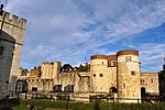 More images |
| The White Tower | Tower of London, Tower Hamlets | Keep | c1078-1100 | 30 November 1989 | TQ3361780548 51°30′29″N 0°04′34″W / 51.508072°N 0.076064°W / 51.508072; -0.076064 (The White Tower) | 1260258 |  More images |
| Tower Bridge (that Part in London Borough of Tower Hamlets) | Tower Hamlets | Footbridge | 1894 | 27 September 1973 | TQ3369780338 51°30′22″N 0°04′30″W / 51.506166°N 0.074992°W / 51.506166; -0.074992 (Tower Bridge (that Part in London Borough of Tower Hamlets)) | 1357515 |  More images |
| Tower Bridge Approach | Tower Hamlets | Balustrade | 1894 | 27 September 1973 | TQ3375380489 51°30′27″N 0°04′27″W / 51.50751°N 0.074128°W / 51.50751; -0.074128 (Tower Bridge Approach) | 1065833 | 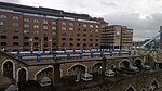 More images |
| Trinity Green (almshouses and Chapel) Including Gates, Railings, Wall and Piers | Tower Hamlets | Gate | 1695 | 29 December 1950 | TQ3505182028 51°31′16″N 0°03′17″W / 51.521032°N 0.054847°W / 51.521032; -0.054847 (Trinity Green (almshouses and Chapel) Including Gates, Railings, Wall and Piers) | 1241071 |  More images |
| Warehouses and General Offices at Western End of North Quay | Tower Hamlets | Warehouse | 1802 | 19 July 1950 | TQ3722880597 51°30′28″N 0°01′27″W / 51.507648°N 0.024046°W / 51.507648; -0.024046 (Warehouses and General Offices at Western End of North Quay) | 1242440 | 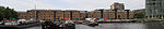 More images |
| 56 Artillery Lane | Tower Hamlets E1 | House | Mid 18th century | 29 December 1950 | TQ3353181667 51°31′05″N 0°04′37″W / 51.518149°N 0.076879°W / 51.518149; -0.076879 (56 Artillery Lane) | 1357760 |  More images |
Grade II*
| Name | Location | Type | Completed [note 1] | Date designated | Grid ref.[note 2] Geo-coordinates | Entry number [note 3] | Image |
|---|---|---|---|---|---|---|---|
| Area Railings at No 2 Christchurch Rectory | Tower Hamlets | Vicarage | Early 18th century | 29 December 1950 | TQ3379181787 51°31′09″N 0°04′23″W / 51.519165°N 0.073089°W / 51.519165; -0.073089 (Area Railings at No 2 Christchurch Rectory) | 1240832 | 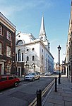 |
| Baroness Burdett Coutts Drinking Fountain | Tower Hamlets | Drinking Fountain | 1862 | 4 February 1975 | TQ3605683840 51°32′13″N 0°02′23″W / 51.537073°N 0.039672°W / 51.537073; -0.039672 (Baroness Burdett Coutts Drinking Fountain) | 1235552 | 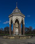 More images |
| V&A Museum of Childhood | Tower Hamlets | Museum | Reassembled | 27 September 1973 | TQ3502782920 51°31′45″N 0°03′17″W / 51.529053°N 0.054851°W / 51.529053; -0.054851 (V&A Museum of Childhood) | 1357777 |  More images |
| Blind Beggar and his Dog | Tower Hamlets | Sculpture | By 1963 | 15 April 1998 | TQ3571483025 51°31′47″N 0°02′42″W / 51.529832°N 0.044913°W / 51.529832; -0.044913 (Blind Beggar and his Dog) | 1031598 |  More images |
| Brick Lane Jamme Masjid (former Neuve Eglise) | Tower Hamlets | Mosque | 1976 | 29 December 1950 | TQ3386181815 51°31′10″N 0°04′19″W / 51.5194°N 0.07207°W / 51.5194; -0.07207 (Brick Lane Jamme Masjid (former Neuve Eglise)) | 1240697 | 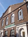 More images |
| Bromley Hall | Tower Hamlets | House | 1993 | 19 July 1950 | TQ3817381908 51°31′09″N 0°00′36″W / 51.519199°N 0.009925°W / 51.519199; -0.009925 (Bromley Hall) | 1357791 |  More images |
| Christ Church | Tower Hamlets | Parish Church | 1852–1854 | 27 September 1973 | TQ3851578561 51°29′21″N 0°00′23″W / 51.489039°N 0.006312°W / 51.489039; -0.006312 (Christ Church) | 1357844 | 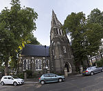 More images |
| Whitechapel Bell Foundry | 32 Whitechapel Rd, Tower Hamlets | Gate | 18th century | 29 December 1950 | TQ3422181543 51°31′01″N 0°04′01″W / 51.516871°N 0.066988°W / 51.516871; -0.066988 (Whitechapel Bell Foundry) | 1357529 |  More images |
| Church of St Anne (Roman Catholic) | Tower Hamlets | Roman Catholic Church | 1850 | 27 September 1973 | TQ3414582010 51°31′16″N 0°04′04″W / 51.521085°N 0.067905°W / 51.521085; -0.067905 (Church of St Anne (Roman Catholic)) | 1357520 |  |
| Church of St George (german Lutheran Church and Vestry) | Tower Hamlets | Vestry | 1762-3 | 29 December 1950 | TQ3398681235 51°30′51″N 0°04′14″W / 51.514159°N 0.070489°W / 51.514159; -0.070489 (Church of St George (german Lutheran Church and Vestry)) | 1065325 | 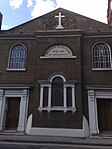 More images |
| Church of St Mary Stratford Bow | Island Site, Tower Hamlets | Church | Possible 14th century | 19 July 1950 | TQ3767582961 51°31′44″N 0°01′00″W / 51.528783°N 0.016686°W / 51.528783; -0.016686 (Church of St Mary Stratford Bow) | 1065273 | 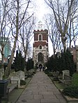 More images |
| Church of St Matthew | Tower Hamlets | Church | 1743–1746 | 18 July 1949 | TQ3418382462 51°31′30″N 0°04′02″W / 51.525138°N 0.067185°W / 51.525138; -0.067185 (Church of St Matthew) | 1065051 | 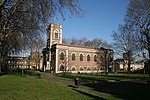 More images |
| Church of St Matthias | Tower Hamlets | Church | 1650–54 | 19 July 1950 | TQ3777680822 51°30′34″N 0°00′58″W / 51.509537°N 0.016067°W / 51.509537; -0.016067 (Church of St Matthias) | 1065793 | 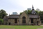 More images |
| Church of St Paul | Tower Hamlets | Vicarage | 1960 | 29 March 1988 | TQ3682381690 51°31′03″N 0°01′46″W / 51.517568°N 0.029454°W / 51.517568; -0.029454 (Church of St Paul) | 1241881 |  More images |
| St Paul's Church, Shadwell | The Highway, London E1 | Church | 1848 | 29 December 1950 | TQ3527880743 51°30′34″N 0°03′07″W / 51.50943°N 0.05207°W / 51.50943; -0.05207 (St Paul's Church, Shadwell) | 1357840 | 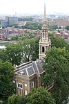 More images |
| East India Dock House, former Financial Times Print Works | 240 East India Dock Road, Tower Hamlets | Print works | 1987-1988 | 24 February 2016 | TQ3858480983 51°30′39″N 0°00′16″W / 51.510786°N 0.0043680318°W / 51.510786; -0.0043680318 (East India Dock House, former Financial Times Print Works) | 1430114 |  More images |
| London Hydraulic Power Company Station with Number 37 | Tower Hamlets | Managers House | 1891 | 27 September 1973 | TQ3531080527 51°30′27″N 0°03′06″W / 51.507481°N 0.051692°W / 51.507481; -0.051692 (London Hydraulic Power Company Station with Number 37) | 1242419 | 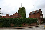 More images |
| Merchant Seamens Memorial | Tower Hamlets | Sculpture | 1952–1955 | 15 April 1998 | TQ3348280729 51°30′35″N 0°04′41″W / 51.509731°N 0.07794°W / 51.509731; -0.07794 (Merchant Seamens Memorial) | 1031597 |  More images |
| Parnell Road Bridge at Tq 367 840 | Hertford Union Canal, Tower Hamlets | Accommodation Bridge | 1830 | 23 October 1990 | TQ3676583988 51°32′18″N 0°01′46″W / 51.538232°N 0.029398°W / 51.538232; -0.029398 (Parnell Road Bridge at Tq 367 840) | 1260227 | 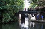 More images |
| Phoenix School | Tower Hamlets | School | 1951–52 | 30 March 1993 | TQ3699282799 51°31′39″N 0°01′36″W / 51.527493°N 0.026589°W / 51.527493; -0.026589 (Phoenix School) | 1065730 |  Upload Photo |
| Railings and Gate with Overthrow at No 37 | Tower Hamlets | House | c. 1700 | 29 December 1950 | TQ3554181942 51°31′13″N 0°02′52″W / 51.520141°N 0.047822°W / 51.520141; -0.047822 (Railings and Gate with Overthrow at No 37) | 1242101 |  |
| Raine's House | Raine Street, London E1W 3RJ | Teachers House | 1719 | 29 December 1950 | TQ3487680418 51°30′24″N 0°03′29″W / 51.506605°N 0.057984°W / 51.506605; -0.057984 (Raine's House) | 1260423 | 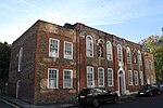 More images |
| Revetment Wall to South Side of Moat, from Tower Bridge Approach to Middle Tower (qv) | Tower of London, Tower Hamlets | Moat | 1365–70 | 30 November 1989 | TQ3361380450 51°30′26″N 0°04′34″W / 51.507193°N 0.076159°W / 51.507193; -0.076159 (Revetment Wall to South Side of Moat, from Tower Bridge Approach to Middle Tower (qv)) | 1065765 |  |
| St Augustine with St Philip's Church | Tower Hamlets | Church | 1888–92 | 29 December 1950 | TQ3467381600 51°31′02″N 0°03′38″W / 51.517276°N 0.060456°W / 51.517276; -0.060456 (St Augustine with St Philip's Church) | 1065066 | 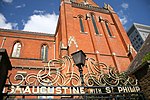 More images |
| Thames Tunnel | Tower Hamlets | Tunnel | 1825–43 | 24 March 1995 | TQ3508380096 51°30′13″N 0°03′18″W / 51.503662°N 0.055126°W / 51.503662; -0.055126 (Thames Tunnel) | 1242119 |  More images |
| The Directors' House, Truman Brewery | Tower Hamlets | Managers House | 1740s | 29 December 1950 | TQ3385282014 51°31′16″N 0°04′20″W / 51.521191°N 0.072124°W / 51.521191; -0.072124 (The Directors' House, Truman Brewery) | 1252152 |  |
| The Old Hospital Block and Raised Terrace and Railings | Tower of London, Tower Hamlets | Apartment | 1989 | 30 November 1989 | TQ3367280545 51°30′29″N 0°04′31″W / 51.508032°N 0.075273°W / 51.508032; -0.075273 (The Old Hospital Block and Raised Terrace and Railings) | 1065767 |  More images |
| The Royal Foundation of St Katherine | Tower Hamlets | House | Late C18/early | 29 December 1950 | TQ3598780972 51°30′41″N 0°02′30″W / 51.511318°N 0.041772°W / 51.511318; -0.041772 (The Royal Foundation of St Katherine) | 1065284 | 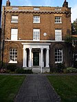 More images |
| The Royal Mint | Tower Hamlets | Mint | 1811 | 27 September 1973 | TQ3386980685 51°30′33″N 0°04′21″W / 51.509244°N 0.072383°W / 51.509244; -0.072383 (The Royal Mint) | 1357516 | 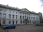 More images |
| The Widow's Son public house | Tower Hamlets | Public House | Early 19th century | 23 October 1974 | TQ3760382232 51°31′20″N 0°01′05″W / 51.522249°N 0.018008°W / 51.522249; -0.018008 (The Widow's Son public house) | 1065801 | 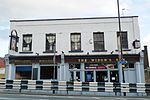 More images |
| Three Colts Bridge at Tq 364837 | Hertford Union Canal, Tower Hamlets | Accommodation Bridge | 1830 | 23 October 1990 | TQ3643583726 51°32′09″N 0°02′03″W / 51.535958°N 0.034255°W / 51.535958; -0.034255 (Three Colts Bridge at Tq 364837) | 1065740 | 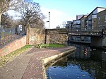 |
| Whitechapel Gallery | Tower Hamlets | Art Gallery | 1897–99 | 27 September 1973 | TQ3398481456 51°30′58″N 0°04′14″W / 51.516145°N 0.070434°W / 51.516145; -0.070434 (Whitechapel Gallery) | 1065820 |  More images |
| Wilton's Music Hall | Tower Hamlets | Club | Mid 19th century | 7 April 1971 | TQ3424180851 51°30′38″N 0°04′01″W / 51.510648°N 0.066963°W / 51.510648; -0.066963 (Wilton's Music Hall) | 1065173 |  More images |
| 26 Tredegar Square | Mile End, Tower Hamlets | Terraced House | 1827 | 29 December 1950 | TQ3658482802 51°31′39″N 0°01′57″W / 51.527618°N 0.032466°W / 51.527618; -0.032466 (26 Tredegar Square) | 1242118 | 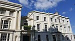 More images |
| Museum of Immigration and Diversity | 19 Princelet Street, Tower Hamlets E1 | Terraced House | 1719 | 20 August 1969 | TQ3382981866 51°31′12″N 0°04′21″W / 51.519866°N 0.072511°W / 51.519866; -0.072511 (Museum of Immigration and Diversity) | 1260421 |  More images |
| 17–18 Victoria Park Square | Tower Hamlets E2 | House | c. 1690 | 18 July 1949 | TQ3513482886 51°31′43″N 0°03′12″W / 51.528722°N 0.053323°W / 51.528722; -0.053323 (17–18 Victoria Park Square) | 1260103 |  |
| War memorial to the children of Upper North Street School | Poplar Recreation Ground | War memorial | 1919 | 27 September 1973 | TQ3772880932 51°30′38″N 0°01′00″W / 51.510537°N 0.016715103°W / 51.510537; -0.016715103 (War memorial to the children of Upper North Street School) | 1065215 |  More images |
| Isle of Dogs Pumping Station | Stewart Street | Pumping station | 1988 | 19 June 2017 | TQ3836779700 51°29′58″N 0°00′29″W / 51.499310°N 0.0079959009°W / 51.499310; -0.0079959009 (Isle of Dogs Pumping Station) | 1447069 | 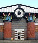 More images |
Notes
- ^ a b The date given is the date used by Historic England as significant for the initial building or that of an important part in the structure's description.
- ^ a b Sometimes known as OSGB36, the grid reference is based on the British national grid reference system used by the Ordnance Survey.
- ^ a b The "List Entry Number" is a unique number assigned to each listed building and scheduled monument by Historic England.
External links
 Media related to Grade I listed buildings in the London Borough of Tower Hamlets at Wikimedia Commons
- Media related to Grade II* listed buildings in the London Borough of Tower Hamlets at Wikimedia Commons
- v
- t
- e
- Bethnal Green
- Blackwall and Cubitt Town
- Bow East
- Bow West
- Bromley North
- Bromley South
- Canary Wharf
- Island Gardens
- Lansbury
- Limehouse
- Mile End
- Poplar
- Shadwell
- Spitalfields and Banglatown
- St Dunstan's
- St Katharine's and Wapping
- St Peter's
- Stepney Green
- Weavers
- Whitechapel


- Brick Lane
- Christ Church, Spitalfields
- Dennis Severs' House
- East Smithfield
- Fish Island
- Fournier Street
- Museum of Immigration and Diversity
- Museum of London Docklands
- Queen Elizabeth Olympic Park
- Ragged School Museum
- Royal London Museum and Archives
- Jack the Ripper Museum
- St Katharine Docks
- Spitalfields City Farm
- Stepney City Farm
- Tower Bridge
- Tower of London
- Traitors' Gate
- Whitechapel Art Gallery
- Young V&A
- Petticoat Lane
- Brick Lane
- Columbia Road
- Old Spitalfields
- Roman Road
- London borough council
- Directly elected mayor
- Civic mayor/speaker of council
- Constituencies: Bethnal Green and Bow
- Poplar and Limehouse
 Aldgate East
 All Saints
- Bethnal Green
 Bethnal Green
- Blackwall
- Bow Church
- Bow Road
- Bromley-by-Bow
- Cambridge Heath
- Canary Wharf (DLR)
 Canary Wharf (Elizabeth line)
- Canary Wharf (tube)
- Crossharbour
- Devons Road
- East India
- Heron Quays
- Island Gardens
- Langdon Park
 Limehouse
- Mile End
- Mudchute
- Poplar
- Shadwell
- Shadwell
- South Quay
- Stepney Green
- Tower Gateway
- Tower Hill
- Wapping
- West India Quay
- Westferry
- Whitechapel


- Council
- Grade I and II* listed buildings
- People
- Public art
- Schools
 Category
- Commons

Portals:
 London
 Architecture


