Grade II listed buildings in the London Borough of Hillingdon
Map all coordinates using OpenStreetMap
Download coordinates as:
- KML
- GPX (all coordinates)
- GPX (primary coordinates)
- GPX (secondary coordinates)
This page is a list of classified buildings Grade IIs in the London Borough of Hillingdon.
| Name | Location | Type | Completed [note 1] | Date designated | Grid ref.[note 2] Geo-coordinates | Entry number [note 3] | Image |
|---|---|---|---|---|---|---|---|
| The Angel, Hayes | 697 Uxbridge Road, Hayes, Middlesex, UB4 8HX. | Pub | 1926 | 13 February 2015 | TQ0878681832 51°31′30″N 0°26′00″W / 51.524934°N 0.433305°W / 51.524934; -0.433305 (The Angel, Hayes) | 1422617 |  More images |
| Black Horse, Eastcote | High Road, Eastcote | Pub | early 19th century | 6 September 1974 | TQ1047788489 51°35′04″N 0°24′24″W / 51.58444°N 0.40666°W / 51.58444; -0.40666 (Black Horse, Eastcote) | 1358380 |  Upload Photo |
| Case is Altered, Eastcote | Southill Lane, Eastcote, London | Pub | 16th century | 6 September 1974 | TQ1068988985 51°35′20″N 0°24′13″W / 51.58878°N 0.40366°W / 51.58878; -0.40366 (Case is Altered, Eastcote) | 1358392 |  More images |
| The Crown, Cowley | High Street, Cowley, London | Pub | 16th century | 6 September 1974 | TQ0538682437 51°31′51″N 0°28′56″W / 51.53096°N 0.48212°W / 51.53096; -0.48212 (The Crown, Cowley) | 1080230 | Upload Photo |
| Eastcote tube station | Field End Road | Tube station | 4 July 1904 | 17 May 1994 | TQ1117787630 51°34′36″N 0°23′49″W / 51.576667°N 0.396944°W / 51.576667; -0.396944 (Eastcote tube station) | 1358405 |  More images |
| Highgrove House, Eastcote | Highgrove House, High Road | House | 1750 | 26 November 1975 | TQ1041788230 51°34′54″N 0°24′28″W / 51.581667°N 0.407778°W / 51.581667; -0.407778 (Highgrove House, Eastcote) | 1080110 | 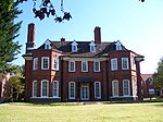 More images |
| Hillingdon Sports and Leisure Complex | Gatting Way, Park Road, Uxbridge | Leisure centre | 1935 | 30 March 1993 | TQ0634284677 51°33′04″N 0°28′03″W / 51.551008°N 0.467603°W / 51.551008; -0.467603 (Hillingdon Sports and Leisure Complex) | 1442596 | 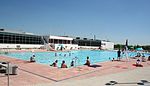 More images |
| Ickenham Hall | Ickenham Hall, Glebe Avenue | Georgian mansion | 1624 | 6 September 1974 | TQ0817585954 51°33′44″N 0°26′27″W / 51.5621°N 0.4408°W / 51.5621; -0.4408 (Ickenham Hall) | 1286099 | 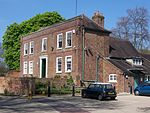 More images |
| Longford Meeting House, Middlesex | Longford Cottage, Bath Road, Longford | Cottage | 16th-century | 6 September 1974 | TQ0529476903 51°28′53″N 0°29′06″W / 51.4813°N 0.48507°W / 51.4813; -0.48507 (Longford Meeting House, Middlesex) | 1286577 |  |
| Polish War Memorial | West End Road | Memorial | 1948 | 30 August 2002 | TQ1101984541 51°32′56″N 0°24′01″W / 51.548809°N 0.400239°W / 51.548809; -0.400239 (Polish War Memorial) | 1088113 |  More images |
| Queen's Head, Uxbridge | 54 Windsor Street, Uxbridge, London | Pub | 6 September 1974 | TQ0549084102 51°32′45″N 0°28′48″W / 51.54587°N 0.47998°W / 51.54587; -0.47998 (Queen's Head, Uxbridge) | 1358443 | 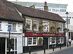 More images | |
| Randalls of Uxbridge | Vine Street | Building | 1938 | 31 October 2008 | TQ0565883957 51°32′41″N 0°28′40″W / 51.544628°N 0.477739°W / 51.544628; -0.477739 (Randalls of Uxbridge) | 1393206 |  More images |
| Red Lion, Hillingdon | Royal Lane | Pub | 1800 | 8 May 1950 | TQ0681082896 51°32′06″N 0°27′40″W / 51.53488°N 0.46114°W / 51.53488; -0.46114 (Red Lion, Hillingdon) | 1358389 |  More images |
| Ruislip tube station | Tube station | 1904 | 4 August 2000 | TQ0951187027 51°34′17″N 0°25′16″W / 51.571389°N 0.421111°W / 51.571389; -0.421111 (Ruislip tube station) | 1380983 |  More images | |
| The Shovel, Cowley | Iver Lane, Cowley, London | Public house | 19th century | 6 September 1974 | TQ0514682289 51°31′47″N 0°29′08″W / 51.52968°N 0.48565°W / 51.52968; -0.48565 (The Shovel, Cowley) | 1080185 | 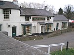 More images |
| Three Tuns, Uxbridge | 24 High Street, Uxbridge, London | Pub | 16th and 17th centuries | 3 April 1973 | TQ0557484063 51°32′44″N 0°28′44″W / 51.54556°N 0.47889°W / 51.54556; -0.47889 (Three Tuns, Uxbridge) | 1285689 | 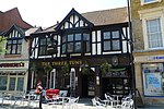 More images |
| Uxbridge tube station | 163-174, High Street | Tube station | 1930 | 12 January 1983 | TQ0559984143 51°32′45″N 0°28′42″W / 51.5459°N 0.4783°W / 51.5459; -0.4783 (Uxbridge tube station) | 1358405 |  More images |
See also
Notes
- ^ The date given is the date used by Historic England as significant for the initial building or that of an important part in the structure's description.
- ^ Sometimes known as OSGB36, the grid reference is based on the British national grid reference system used by the Ordnance Survey.
- ^ The "List Entry Number" is a unique number assigned to each listed building and scheduled monument by Historic England.
External links
 Media related to Grade II listed buildings in the London Borough of Hillingdon at Wikimedia Commons
- v
- t
- e
- Cranford
- Eastcote
- Harefield
- Harlington
- Harmondsworth, Longford and Sipson
- Hatton Cross
- Hayes
- Hillingdon, North Hillingdon and Hillingdon Heath
- Ickenham
- Northwood
- Ruislip and South Ruislip
- Ruislip Gardens
- Ruislip Manor
- Uxbridge
- West Drayton
- Yeading
- Yiewsley and Cowley


- Battle of Britain Bunker
- Beck Theatre
- The Chimes, Uxbridge
- Compass Theatre
- Eastcote House Gardens
- Heathrow Airport
- Hillingdon Cycle Circuit
- Hillingdon Sports and Leisure Complex
- Ickenham Hall
- London Motor Museum, Hayes
- Manor Farm
- Open Air Theatre, Barra Hall Park
- The Pavilions
- Polish War Memorial
- Ruislip Lido (Ruislip Lido Railway)
- Southlands Arts Centre
- Swakeleys House
- Uxbridge Cricket Club Ground
- Barra Hall Park
- Bayhurst Wood
- The Closes Recreation Ground
- Copse Wood
- Crane Meadows
- Cranford Park
- Denham Lock Wood
- Frays Farm Meadows
- Hillingdon Court
- Ickenham Marsh
- Lake Farm Country Park
- Mad Bess Wood
- Mid Colne Valley
- Minet Country Park
- Norman Leddy Memorial Gardens
- Old Park Wood
- Park Wood
- Rockingham Recreation Ground
- Ruislip Lido
- Uxbridge Common
- Yeading Brook Meadows
- Colne Valley Regional Park (section)
- Hayes & Harlington
- Ruislip, Northwood & Pinner
- Uxbridge & South Ruislip

- Coat of arms
- Listed buildings
- Grade I and II*
- Grade II
- Hospital
- People
- Public art
- Radio
- Schools
 Category
- Commons

Portals:
 London
 Architecture


