Grade II* listed buildings in Taunton Deane

Taunton Deane is a local government district with borough status in the English county of Somerset. In the United Kingdom, the term listed building refers to a building or other structure officially designated as being of special architectural, historical or cultural significance; Grade II* structures are those considered to be "particularly significant buildings of more than local interest".[1] Listing was begun by a provision in the Town and Country Planning Act 1947. Once listed, severe restrictions are imposed on the modifications allowed to a building's structure or its fittings. In England, the authority for listing under the Planning (Listed Buildings and Conservation Areas) Act 1990 rests with Historic England, a non-departmental public body sponsored by the Department for Digital, Culture, Media and Sport; local authorities have a responsibility to regulate and enforce the planning regulations.[2]
Taunton Deane has an area of 462 square kilometres (178 square miles), and a population as of 2016 of 115,500.[3][4] It is centred on the town of Taunton, where around 60,000 of the population live and the council are based, and includes surrounding suburbs and villages.[3]
There are 118 Grade II* listed buildings in Taunton Deane. The oldest is St George's Church, Fons George which has Saxon origins.[5] There are also Norman and medieval churches and churchyard crosses. More recent buildings include country houses and barns along with municipal buildings and an almshouse.[6] The list also includes urban properties such as those in Hammet Street and The Crescent in Taunton. Industrial sites are represented by Tonedale Mills in Wellington, the largest woollen mill in South West England.[7]
Map all coordinates using OpenStreetMap
Download coordinates as:
- KML
- GPX (all coordinates)
- GPX (primary coordinates)
- GPX (secondary coordinates)
Buildings
| Name | Location | Type | Completed [note 1] | Grid ref.[note 2] Geo-coordinates | Entry number [note 3] | Image | Ref. |
|---|---|---|---|---|---|---|---|
| 1–6, Cheapside | Taunton | Shop | Early 19th century | ST228244 51°00′51″N 3°06′05″W / 51.0143°N 3.1013°W / 51.0143; -3.1013 (1–6, Cheapside) | 1060078 |  | [8] |
| 1–11, The Crescent | Taunton | Terrace | 1807 | ST225243 51°00′47″N 3°06′20″W / 51.0131°N 3.1056°W / 51.0131; -3.1056 (1–11, The Crescent) | 1344699 |  | [9] |
| 4, 5–8, Hammet Street | Taunton | Terrace | 1788–90 | ST228245 51°00′55″N 3°06′06″W / 51.0154°N 3.1018°W / 51.0154; -3.1018 (4, 5–8, Hammet Street) | 1276877 | 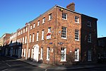 | [10] |
| 5 and 7, The Square | Wiveliscombe | House | 1881 | ST081278 51°02′33″N 3°18′44″W / 51.0426°N 3.3122°W / 51.0426; -3.3122 (5 and 7, The Square) | 1307465 | 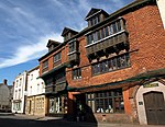 | [11] |
| 9–12, Hammet Street | Taunton | Terrace | 1788–90 | ST228245 51°00′55″N 3°06′06″W / 51.0153°N 3.1016°W / 51.0153; -3.1016 (9–12, Hammet Street) | 1060037 | 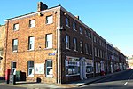 | [12] |
| 12, Middle Street | Taunton | House | c. 1700 | ST228247 51°01′00″N 3°06′05″W / 51.0167°N 3.1014°W / 51.0167; -3.1014 (12, Middle Street) | 1344725 | 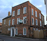 | [13] |
| 13–17, Hammet Street | Taunton | Terrace | 1788–90 | ST227245 51°00′54″N 3°06′08″W / 51.0151°N 3.1021°W / 51.0151; -3.1021 (13–17, Hammet Street) | 1344735 | 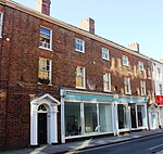 | [14] |
| 15, 16–20, The Crescent | Taunton | Terrace | 1807 | ST225242 51°00′45″N 3°06′19″W / 51.0126°N 3.1053°W / 51.0126; -3.1053 (15, 16–20, The Crescent) | 1060043 |  | [15] |
| 16–20, Park Street | Taunton | Terrace | Mid Victorian | ST222243 51°00′49″N 3°06′37″W / 51.0135°N 3.1102°W / 51.0135; -3.1102 (16–20, Park Street) | 1059993 | 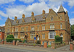 | [16] |
| No 18, Fore Street | Taunton | House | 16th or early 17th century | ST226244 51°00′51″N 3°06′13″W / 51.0143°N 3.1037°W / 51.0143; -3.1037 (No 18, Fore Street) | 1232670 |  More images | [17] |
| 24–28, Silver Street | Taunton | House | Probably very early 19th century | ST231244 51°00′50″N 3°05′50″W / 51.0138°N 3.0972°W / 51.0138; -3.0972 (24–28, Silver Street) | 1276486 |  | [18] |
| 48, East Street | Taunton | House | Mid 18th century | ST230245 51°00′53″N 3°05′54″W / 51.0147°N 3.0984°W / 51.0147; -3.0984 (48, East Street) | 1060057 | 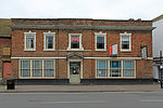 | [19] |
| 115 and 117, Galmington Road, 2, Galmington Lane | Taunton | Cross passage house | Medieval | ST212238 51°00′31″N 3°07′27″W / 51.0085°N 3.1242°W / 51.0085; -3.1242 (115 and 117, Galmington Road, 2, Galmington Lane) | 1276934 |  | [20] |
| Almshouses | Staple Fitzpaine | Flats | 1643 | ST264182 50°57′33″N 3°02′57″W / 50.9593°N 3.0493°W / 50.9593; -3.0493 (Almshouses) | 1060273 |  Upload Photo | [21] |
| Bagborough House | West Bagborough | Country house | c. 1730 | ST168337 51°05′48″N 3°11′18″W / 51.0966°N 3.1884°W / 51.0966; -3.1884 (Bagborough House) | 1060526 |  More images | [22] |
| Blagrove's Farmhouse (and adjoining walls to the north west and south west) | Oake | Farmhouse | Late 17th century | ST145256 51°01′26″N 3°13′12″W / 51.0238°N 3.2199°W / 51.0238; -3.2199 (Blagrove's Farmhouse (and adjoining walls to the north west and south west)) | 1344563 |  (and adjoining walls to the north west and south west) More images | [23] |
| Bradford Bridge | Bradford-on-Tone | Road bridge | 15th century | ST171229 51°00′01″N 3°10′53″W / 51.0004°N 3.1815°W / 51.0004; -3.1815 (Bradford Bridge) | 1060375 |  More images | [24] |
| Buckland Farmhouse | West Buckland | Farmhouse | Late 16th century | ST181193 50°58′05″N 3°10′00″W / 50.9681°N 3.1666°W / 50.9681; -3.1666 (Buckland Farmhouse) | 1180164 | Upload Photo | [25] |
| Bulford House | Wellington | House | 18th century | ST141203 50°58′33″N 3°13′29″W / 50.9758°N 3.2246°W / 50.9758; -3.2246 (Bulford House) | 1059874 | Upload Photo | [26] |
| Chilliswood Farmhouse (with horse-engine house and barn) | Trull | House | Medieval | ST198220 50°59′31″N 3°08′34″W / 50.9919°N 3.1429°W / 50.9919; -3.1429 (Chilliswood Farmhouse (with horse-engine house and barn)) | 1060445 |  (with horse-engine house and barn) | [27] |
| Church of All Saints | Chipstable | Parish church | 15th century | ST042271 51°02′08″N 3°22′00″W / 51.0356°N 3.3667°W / 51.0356; -3.3667 (Church of All Saints) | 1344603 |  More images | [28] |
| Church of All Saints | Norton Fitzwarren | Parish church | Late 13th or early 14th century | ST196259 51°01′39″N 3°08′48″W / 51.0275°N 3.1467°W / 51.0275; -3.1467 (Church of All Saints) | 1060468 | 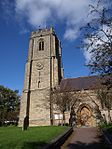 More images | [29] |
| Church of St Andrew | Wiveliscombe | Church | 1827–29 | ST082276 51°02′28″N 3°18′35″W / 51.0411°N 3.3098°W / 51.0411; -3.3098 (Church of St Andrew) | 1177072 |  More images | [30] |
| Church of St Bartholomew | Oake | Parish church | 13th–14th century | ST152251 51°01′11″N 3°12′35″W / 51.0197°N 3.2096°W / 51.0197; -3.2096 (Church of St Bartholomew) | 1307395 | 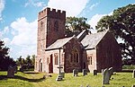 More images | [31] |
| Church of St George | Taunton | Church | Saxon | ST224239 51°00′33″N 3°06′23″W / 51.0093°N 3.1065°W / 51.0093; -3.1065 (Church of St George) | 1060018 |  More images | [32] |
| Church of St Giles | Bradford on Tone | Parish church | c. 1300 | ST173229 51°00′01″N 3°10′48″W / 51.0002°N 3.1799°W / 51.0002; -3.1799 (Church of St Giles) | 1060376 |  More images | [33] |
| Church of St James | Taunton | Church | Medieval | ST228248 51°01′04″N 3°06′04″W / 51.0178°N 3.1012°W / 51.0178; -3.1012 (Church of St James) | 1059956 | 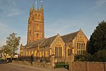 More images | [34] |
| Church of St James the Great | Fitzhead | Church | 15th century | ST119283 51°02′53″N 3°15′26″W / 51.0481°N 3.2571°W / 51.0481; -3.2571 (Church of St James the Great) | 1175726 | 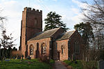 More images | [35] |
| Church of St John the Baptist | Ashbrittle | Church | 15th century | ST052213 50°59′02″N 3°21′07″W / 50.9838°N 3.3519°W / 50.9838; -3.3519 (Church of St John the Baptist) | 1059880 | 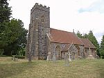 More images | [36] |
| Church of St Leonard | Otterford | Parish church | 14th century | ST222143 50°55′23″N 3°06′28″W / 50.9231°N 3.1077°W / 50.9231; -3.1077 (Church of St Leonard) | 1344635 |  More images | [37] |
| Church of St Margaret | Thorne St Margaret | Parish church | 15th century | ST098210 50°58′56″N 3°17′07″W / 50.9822°N 3.2854°W / 50.9822; -3.2854 (Church of St Margaret) | 1180128 | 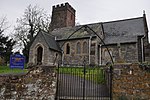 More images | [38] |
| Church of St Mary | Cheddon Fitzpaine | Parish church | Late 13th century | ST242275 51°02′34″N 3°04′53″W / 51.0427°N 3.0813°W / 51.0427; -3.0813 (Church of St Mary) | 1060508 | 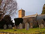 More images | [39] |
| Church of St Mary | Stoke St Mary | Parish church | 13th century | ST265223 50°59′45″N 3°02′51″W / 50.9957°N 3.0476°W / 50.9957; -3.0476 (Church of St Mary) | 1177216 |  More images | [40] |
| Church of St Michael | Orchard Portman | Parish church | Norman | ST243216 50°59′21″N 3°04′44″W / 50.9893°N 3.078895°W / 50.9893; -3.078895 (Church of St Michael) | 1060391 | 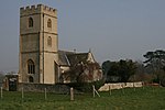 More images | [41] |
| Church of St Michael | Angersleigh | Parish church | 14th century | ST199187 50°57′44″N 3°08′31″W / 50.9621°N 3.1419°W / 50.9621; -3.1419 (Church of St Michael) | 1177574 |  More images | [42] |
| Church of St Nicholas | Corfe | Parish church | Norman | ST232196 50°58′17″N 3°05′40″W / 50.9715°N 3.0945°W / 50.9715; -3.0945 (Church of St Nicholas) | 1060345 |  More images | [43] |
| Church of St Nicholas | Kittisford | Church | c. 1500 | ST078223 50°59′34″N 3°18′53″W / 50.9929°N 3.3148°W / 50.9929; -3.3148 (Church of St Nicholas) | 1176263 |  More images | [44] |
| Church of St Pancras | West Bagborough | Church | 1643 | ST168337 51°05′48″N 3°11′20″W / 51.0966°N 3.188843°W / 51.0966; -3.188843 (Church of St Pancras) | 1344480 | 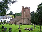 More images | [45] |
| Church of St Peter | Runnington, Langford Budville | Parish church | 15th century | ST118218 50°59′22″N 3°15′24″W / 50.9895°N 3.2567°W / 50.9895; -3.2567 (Church of St Peter) | 1060352 |  More images | [46] |
| Church of St Peter and St Paul | Bishop's Hull | Church | 13th century | ST204247 51°01′00″N 3°08′06″W / 51.01667°N 3.1350°W / 51.01667; -3.1350 (Church of St Peter and St Paul) | 1060537 |  More images | [47] |
| Church of the Holy Cross | Hillfarrance, Oake | Parish church | 14th century | ST167246 51°00′54″N 3°11′18″W / 51.0151°N 3.1882°W / 51.0151; -3.1882 (Church of the Holy Cross) | 1060326 |  More images | [48] |
| Church of the Holy Trinity | Ash Priors | Church | 15th century | ST151294 51°03′30″N 3°12′42″W / 51.0584°N 3.2117°W / 51.0584; -3.2117 (Church of the Holy Trinity) | 1344823 |  More images | [49] |
| Churchyard cross, Church of St Andrew | Wiveliscombe | Cross | 14th century | ST082276 51°02′28″N 3°18′34″W / 51.0412°N 3.3095°W / 51.0412; -3.3095 (Churchyard cross, Church of St Andrew) | 1177103 |  Church of St Andrew | [50] |
| Churchyard cross, Church of St James the Great | Fitzhead | Sculpture | 14th century | ST119283 51°02′52″N 3°15′26″W / 51.0479°N 3.2572°W / 51.0479; -3.2572 (Churchyard cross, Church of St James the Great) | 1059198 | 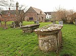 Church of St James the Great | [51] |
| Churchyard cross, Church of St John the Baptist | Heathfield | Cross | Late 13th century | ST160264 51°01′53″N 3°11′57″W / 51.0313°N 3.1992°W / 51.0313; -3.1992 (Churchyard cross, Church of St John the Baptist) | 1307462 |  Church of St John the Baptist More images | [52] |
| Churchyard cross, Church of St Mary | Bishops Lydeard | Steps | 14th century | ST167297 51°03′39″N 3°11′21″W / 51.0609°N 3.1892°W / 51.0609; -3.1892 (Churchyard cross, Church of St Mary) | 1175069 | 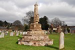 Church of St Mary | [53] |
| Churchyard cross, Church of St Peter and St Paul | Combe Florey | Cross | 15th century | ST150311 51°04′24″N 3°12′49″W / 51.0734°N 3.2137°W / 51.0734; -3.2137 (Churchyard cross, Church of St Peter and St Paul) | 1059225 | 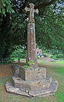 Church of St Peter and St Paul | [54] |
| Churchyard cross, Church of St Peter and St Paul | North Curry | Cross | 15th century | ST319254 51°01′29″N 2°58′18″W / 51.0247°N 2.9716°W / 51.0247; -2.9716 (Churchyard cross, Church of St Peter and St Paul) | 1060411 | Upload Photo | [55] |
| Cloth Finishing Works at Tone Mills (North range including dye-house and reservoirs) | Wellington | Reservoir | c. 1830 | ST127212 50°59′02″N 3°14′38″W / 50.9839°N 3.2440°W / 50.9839; -3.2440 (Cloth Finishing Works at Tone Mills (North range including dye-house and reservoirs)) | 1271246 |  (North range including dye-house and reservoirs) More images | [56] |
| Coalharbour | Creech St Michael | House | 16th century | ST288253 51°01′22″N 3°00′55″W / 51.0229°N 3.0152°W / 51.0229; -3.0152 (Coalharbour) | 1344519 | Upload Photo | [57] |
| Conservative Club | Taunton | House | 1805 | ST228246 51°00′57″N 3°06′05″W / 51.0157°N 3.1014°W / 51.0157; -3.1014 (Conservative Club) | 1231461 |  More images | [58][59] |
| Cothelstone Manor | Cothelstone | Manor house | Mid 16th century | ST181318 51°04′47″N 3°10′12″W / 51.0797°N 3.1699°W / 51.0797; -3.1699 (Cothelstone Manor) | 1344838 |  More images | [60] |
| County Hotel | Taunton | House | Early 19th century | ST228244 51°00′51″N 3°06′03″W / 51.0143°N 3.1007°W / 51.0143; -3.1007 (County Hotel) | 1060016 |  More images | [61] |
| Fairhouse Farmhouse | Churchstanton | Farmhouse | Late Medieval | ST219123 50°54′18″N 3°06′43″W / 50.9049°N 3.1119°W / 50.9049; -3.1119 (Fairhouse Farmhouse) | 1177497 | Upload Photo | [62] |
| Fitzhead Court and The Manor | Fitzhead | House | Late 16th century | ST121284 51°02′56″N 3°15′14″W / 51.0490°N 3.2540°W / 51.0490; -3.2540 (Fitzhead Court and The Manor) | 1059202 |  More images | [63] |
| Garden House | Pitminster | Garden house | 17th century | ST222202 50°58′33″N 3°06′34″W / 50.9759°N 3.1094°W / 50.9759; -3.1094 (Garden House) | 1344593 | Upload Photo | [64] |
| Gatehouse, Cothay Manor (and wall linking gatehouse to manor) | Stawley | Gatehouse | Late 15th century | ST085212 50°59′02″N 3°18′16″W / 50.9838°N 3.3045°W / 50.9838; -3.3045 (Gatehouse, Cothay Manor (and wall linking gatehouse to manor)) | 1344803 |  (and wall linking gatehouse to manor) | [65] |
| Gatehouse, Combe Florey House | Combe Florey | Gatehouse | 1591 | ST151311 51°04′24″N 3°12′47″W / 51.0734°N 3.2130°W / 51.0734; -3.2130 (Gatehouse, Combe Florey House) | 1059226 |  More images | [66] |
| Gaulden Manor | Tolland | House | 16th century | ST110313 51°04′29″N 3°16′14″W / 51.0746°N 3.2706°W / 51.0746; -3.2706 (Gaulden Manor) | 1307623 | Upload Photo | [67] |
| Gazebo, Cothelstone Manor (and adjoining walls) | Cothelstone | Wall | Late 16th century | ST182318 51°04′48″N 3°10′08″W / 51.0799°N 3.1688°W / 51.0799; -3.1688 (Gazebo, Cothelstone Manor (and adjoining walls)) | 1059193 | Upload Photo | [68] |
| Gerbestone Manor | West Buckland | Cross passage house | Late 16th century | ST161193 50°58′04″N 3°11′42″W / 50.9677°N 3.1950°W / 50.9677; -3.1950 (Gerbestone Manor) | 1344582 |  More images | [69] |
| Giffords Farmhouse and Barn | Norton Fitzwarren | Farmhouse | 16th century | ST199270 51°02′12″N 3°08′34″W / 51.0368°N 3.1427°W / 51.0368; -3.1427 (Giffords Farmhouse and Barn) | 1060466 | Upload Photo | [70] |
| Hamwood Farmhouse (and walls with gate-piers and gate) | Trull | Farmhouse | 17th century | ST197211 50°59′01″N 3°08′43″W / 50.9837°N 3.1452°W / 50.9837; -3.1452 (Hamwood Farmhouse (and walls with gate-piers and gate)) | 1344504 | Upload Photo | [71] |
| Henlade House | Ruishton | Country house | 1805–15 | ST272230 51°00′08″N 3°02′15″W / 51.0023°N 3.0376°W / 51.0023; -3.0376 (Henlade House) | 1060397 |  More images | [72] |
| Hestercombe House | Cheddon Fitzpaine | Country house | 16th century | ST241287 51°03′10″N 3°05′01″W / 51.0528°N 3.0835°W / 51.0528; -3.0835 (Hestercombe House) | 1060513 | 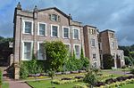 More images | [73] |
| Hill Farmhouse | Stawley | Farmhouse | Late 16th century | ST061218 50°59′18″N 3°20′18″W / 50.9884°N 3.3384°W / 50.9884; -3.3384 (Hill Farmhouse) | 1176991 |  More images | [74] |
| Homedale | Milverton | House | 16th–17th century | ST121258 51°01′31″N 3°15′13″W / 51.0252°N 3.2536°W / 51.0252; -3.2536 (Homedale) | 1060553 | Upload Photo | [75] |
| Kittisford Barton | Stawley | House | Late 15th century | ST076231 51°00′03″N 3°19′01″W / 51.0007°N 3.3170°W / 51.0007; -3.3170 (Kittisford Barton) | 1307955 |  More images | [76] |
| Langford Court | Langford Budville | House | 17th century | ST108230 50°59′59″N 3°16′16″W / 50.9997°N 3.271173°W / 50.9997; -3.271173 (Langford Court) | 1060351 | Upload Photo | [77] |
| Little Court | West Bagborough | House | Late 20th century | ST167334 51°05′41″N 3°11′26″W / 51.0946°N 3.1906°W / 51.0946; -3.1906 (Little Court) | 1176957 | Upload Photo | [78] |
| Lodge Farmhouse | Durston | Farmhouse | 15th century | ST290281 51°02′55″N 3°00′46″W / 51.0486°N 3.0129°W / 51.0486; -3.0129 (Lodge Farmhouse) | 1060491 | Upload Photo | [79] |
| Lower Stoford Farmhouse (and wall, gate-piers) | Halse | Farmhouse | Late 15th or early 16th century | ST144287 51°03′07″N 3°13′18″W / 51.0520°N 3.2217°W / 51.0520; -3.2217 (Lower Stoford Farmhouse (and wall, gate-piers)) | 1308046 | 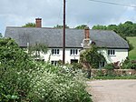 (and wall, gate-piers) More images | [80] |
| Lower Terhill Farmhouse | Bishops Lydeard | Farmhouse | 16th century | ST176326 51°05′15″N 3°10′35″W / 51.0875°N 3.1765°W / 51.0875; -3.1765 (Lower Terhill Farmhouse) | 1344853 |  | [81] |
| Lydeard House (and attached stables and walls) | Bishops Lydeard | Country house | Early–mid 18th century | ST166298 51°03′44″N 3°11′25″W / 51.0623°N 3.1904°W / 51.0623; -3.1904 (Lydeard House (and attached stables and walls)) | 1295371 |  (and attached stables and walls) More images | [82] |
| Manor Farmhouse | Stoke Road, North Curry | Farmhouse | 1570 | ST322252 51°01′21″N 2°58′04″W / 51.0226°N 2.9678°W / 51.0226; -2.9678 (Manor Farmhouse) | 1176349 | Upload Photo | [83] |
| Manor Farmhouse | Knapp, North Curry | Farmhouse | Late Medieval | ST305255 51°01′31″N 2°59′32″W / 51.0253°N 2.9923°W / 51.0253; -2.9923 (Manor Farmhouse) | 1176652 | Upload Photo | [84] |
| Manor House | Bishop's Hull | Manor house | 1586 | ST205248 51°01′02″N 3°08′02″W / 51.0172°N 3.1339°W / 51.0172; -3.1339 (Manor House) | 1060535 |  More images | [85] |
| Market House | Taunton | House | 1770–72 | ST227244 51°00′53″N 3°06′10″W / 51.0146°N 3.1028°W / 51.0146; -3.1028 (Market House) | 1059989 |  More images | [86] |
| Masonic Hall | Taunton | Steps | 1812 | ST225242 51°00′45″N 3°06′18″W / 51.0124°N 3.1051°W / 51.0124; -3.1051 (Masonic Hall) | 1060044 |  More images | [87] |
| Mausoleum, Hestercombe House | West Monkton | Folly | Late 18th century | ST243289 51°03′16″N 3°04′51″W / 51.0545°N 3.080725°W / 51.0545; -3.080725 (Mausoleum, Hestercombe House) | 1060461 |  More images | [88] |
| Municipal Buildings (incorporating the Old Grammar School) | Taunton | Local government office | c. 1480 | ST226245 51°00′54″N 3°06′16″W / 51.0149°N 3.1044°W / 51.0149; -3.1044 (Municipal Buildings (incorporating the Old Grammar School)) | 1060041 |  (incorporating the Old Grammar School) More images | [89] |
| Musgrave Farmhouse | Ruishton | Farmhouse | Mid 19th century | ST269235 51°00′25″N 3°02′35″W / 51.0069°N 3.0431°W / 51.0069; -3.0431 (Musgrave Farmhouse) | 1177045 | Upload Photo | [90] |
| Netherfield | Milverton | House | c. 1766 | ST119256 51°01′25″N 3°15′23″W / 51.0237°N 3.2564°W / 51.0237; -3.2564 (Netherfield) | 1176748 | 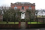 More images | [91] |
| North Lodge | Bishops Lydeard | Early 18th century | ST155303 51°03′58″N 3°12′23″W / 51.0661°N 3.2064°W / 51.0661; -3.2064 (North Lodge) | 1059222 | Upload Photo | [92] | |
| Nynehead Court (and adjoining wall) | Nynehead | Kitchen | Late Medieval | ST137227 50°59′51″N 3°13′51″W / 50.9976°N 3.2307°W / 50.9976; -3.2307 (Nynehead Court (and adjoining wall)) | 1307540 | 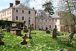 (and adjoining wall) More images | [93] |
| Old Court | Wellington | House | 16th century | ST137204 50°58′38″N 3°13′49″W / 50.9771°N 3.2302°W / 50.9771; -3.2302 (Old Court) | 1059899 | Upload Photo | [94] |
| Outbuilding with wall, Haydon House | Stoke St Mary | Wash house | Late 17th century | ST255235 51°00′24″N 3°03′45″W / 51.0067°N 3.0624°W / 51.0067; -3.0624 (Outbuilding with wall, Haydon House) | 1177118 | Upload Photo | [95] |
| Poundisford Lodge | Pitminster | Country house | 17th century | ST222207 50°58′52″N 3°06′32″W / 50.9811°N 3.1088°W / 50.9811; -3.1088 (Poundisford Lodge) | 1344592 |  More images | [96] |
| Priory Barn | Taunton | Augustinian monastery | 1220 | ST230249 51°01′08″N 3°05′56″W / 51.0189°N 3.0990°W / 51.0189; -3.0990 (Priory Barn) | 1344774 |  More images | [97] |
| Pyleigh Manor | Lydeard St Lawrence | Farmhouse | 16th century | ST128308 51°04′14″N 3°14′45″W / 51.0705°N 3.2458°W / 51.0705; -3.2458 (Pyleigh Manor) | 1344481 | Upload Photo | [98] |
| Pyrland Hall | Cheddon Fitzpaine | Country house | c. 1760 | ST227276 51°02′34″N 3°06′13″W / 51.0427°N 3.1037°W / 51.0427; -3.1037 (Pyrland Hall) | 1176079 | Upload Photo | [99] |
| Queens College | Comeytrowe | Further education college | 1874 | ST217231 51°00′08″N 3°07′02″W / 51.0023°N 3.1172°W / 51.0023; -3.1172 (Queens College) | 1276273 | 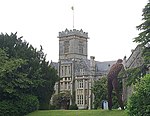 More images | [100] |
| Remains of Churchyard cross, Church of St George | Ruishton | Cross | Early 15th century | ST263250 51°01′14″N 3°03′04″W / 51.0205°N 3.0512°W / 51.0205; -3.0512 (Remains of Churchyard cross, Church of St George) | 1060396 | Upload Photo | [101] |
| Remains of Churchyard cross, Church of All Saints | Nynehead | Cross | 15th century | ST137227 50°59′51″N 3°13′48″W / 50.9975°N 3.2300°W / 50.9975; -3.2300 (Remains of Churchyard cross, Church of All Saints) | 1344597 | Upload Photo | [102] |
| Risdons | Bradford-on-Tone | Farmhouse | 16th century | ST173226 50°59′50″N 3°10′47″W / 50.9973°N 3.1798°W / 50.9973; -3.1798 (Risdons) | 1060337 | Upload Photo | [103] |
| Roman Catholic Church of St George | Taunton | Church | 1861 | ST230242 51°00′46″N 3°05′55″W / 51.0128°N 3.0985°W / 51.0128; -3.0985 (Roman Catholic Church of St George) | 1231201 |  More images | [104] |
| Sandhill Park Hospital | Bishops Lydeard | Country house | c. 1720 | ST156298 51°03′43″N 3°12′19″W / 51.0619°N 3.2054°W / 51.0619; -3.2054 (Sandhill Park Hospital) | 1295317 | 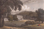 More images | [105] |
| Sherford House | Taunton | House | 1679 | ST226233 51°00′14″N 3°06′13″W / 51.0040°N 3.1035°W / 51.0040; -3.1035 (Sherford House) | 1233681 | Upload Photo | [106] |
| Slough Farmhouse | Stoke St Gregory | Double ended hall house | Late Medieval | ST347277 51°02′42″N 2°55′54″W / 51.0450°N 2.9317°W / 51.0450; -2.9317 (Slough Farmhouse) | 1344637 | Upload Photo | [107] |
| St Joseph's Convent | Taunton | House | Early 19th century | ST232241 51°00′41″N 3°05′44″W / 51.0115°N 3.0956°W / 51.0115; -3.0956 (St Joseph's Convent) | 1276422 |  More images | [108] |
| St Margaret's Leper Hospital | Taunton | Almshouse | Early 16th century | ST238248 51°01′03″N 3°05′14″W / 51.0176°N 3.0871°W / 51.0176; -3.0871 (St Margaret's Leper Hospital) | 1232831 |  More images | [109] |
| Summerhouse at Language Centre | Taunton | Summerhouse | Late 19th century | ST221251 51°01′12″N 3°06′41″W / 51.0201°N 3.1113°W / 51.0201; -3.1113 (Summerhouse at Language Centre) | 1059936 |  | [110] |
| Tetton House (and terrace to garden) | Kingston St Mary | Country house | c. 1790 | ST207304 51°04′04″N 3°07′54″W / 51.0679°N 3.1318°W / 51.0679; -3.1318 (Tetton House (and terrace to garden)) | 1307958 |  (and terrace to garden) More images | [111] |
| Temple, Hestercombe House | West Monkton | Garden temple | Late 18th century | ST243289 51°03′17″N 3°04′52″W / 51.0548°N 3.0811°W / 51.0548; -3.0811 (Temple, Hestercombe House) | 1390976 |  More images | [112] |
| The Manor House | Kingston St Mary | Cross passage house | c. 1560 | ST220297 51°03′42″N 3°06′47″W / 51.0618°N 3.1130°W / 51.0618; -3.1130 (The Manor House) | 1060501 | Upload Photo | [113] |
| The Old House | Milverton | House | Late 15th or early 16th century | ST122258 51°01′32″N 3°15′10″W / 51.0256°N 3.2529°W / 51.0256; -3.2529 (The Old House) | 1060552 | Upload Photo | [114] |
| The Old Manor House | Combe Florey | House | 17th century | ST153312 51°04′27″N 3°12′35″W / 51.0741°N 3.2098°W / 51.0741; -3.2098 (The Old Manor House) | 1059230 | Upload Photo | [115] |
| Tonedale Mills (East complex) | Wellington | Carpenters' workshop | Late 19th century | ST128213 50°59′05″N 3°14′36″W / 50.9848°N 3.2433°W / 50.9848; -3.2433 (Tonedale Mills (East complex)) | 1176514 | Upload Photo | [116] |
| Tonedale Mills (West complex) | Wellington | Industrial estate | Late 20th century | ST127213 50°59′04″N 3°14′42″W / 50.9845°N 3.2451°W / 50.9845; -3.2451 (Tonedale Mills (West complex)) | 1051987 |  (West complex) More images | [117] |
| Trowell Farmhouse | Chipstable | Farmhouse | 17th century | ST048260 51°01′33″N 3°21′30″W / 51.0259°N 3.3583°W / 51.0259; -3.3583 (Trowell Farmhouse) | 1177577 | Upload Photo | [118] |
| Unidentified chest tomb in Churchyard, Church of St Augustine | West Monkton | Chest Tomb | Late 17th century | ST263284 51°03′02″N 3°03′10″W / 51.0506°N 3.0528°W / 51.0506; -3.0528 (Unidentified chest tomb in Churchyard, Church of St Augustine) | 1307458 | Upload Photo | [119] |
| Unitarian chapel | Taunton | Unitarian Chapel | 1721 | ST227242 51°00′44″N 3°06′08″W / 51.0122°N 3.1022°W / 51.0122; -3.1022 (Unitarian chapel) | 1060009 | 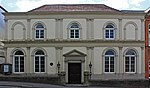 More images | [120] |
| Walford House | West Monkton | House | Late 18th century | ST272282 51°02′55″N 3°02′24″W / 51.0485°N 3.0399°W / 51.0485; -3.0399 (Walford House) | 1060421 |  More images | [121] |
| Washer's Farmhouse | Fitzhead | Farmhouse | Early 17th century | ST115286 51°03′01″N 3°15′48″W / 51.0504°N 3.2633°W / 51.0504; -3.2633 (Washer's Farmhouse) | 1059205 | Upload Photo | [122] |
| Wellington Monument | Wellington Without | Obelisk | 1817–18 | ST137172 50°56′53″N 3°13′45″W / 50.9480°N 3.2293°W / 50.9480; -3.2293 (Wellington Monument) | 1060281 |  More images | [123] |
| Wheatleigh House | Taunton | House | Early to mid 19th century | ST220237 51°00′29″N 3°06′43″W / 51.0081°N 3.1120°W / 51.0081; -3.1120 (Wheatleigh House) | 1039998 |  More images | [124] |
| Yarde Farmhouse | Staplegrove | Farmhouse | Early 17th century | ST201273 51°02′25″N 3°08′25″W / 51.0402°N 3.1403°W / 51.0402; -3.1403 (Yarde Farmhouse) | 1344515 | Upload Photo | [125] |
See also
Notes
- ^ The date given is the date used by Historic England as significant for the initial building or that of an important part in the structure's description.
- ^ Sometimes known as OSGB36, the grid reference is based on the British national grid reference system used by the Ordnance Survey.
- ^ The "List Entry Number" is a unique number assigned to each listed building and scheduled monument by Historic England.
References
- ^ "Listed Buildings". Historic England. Retrieved 23 August 2017.
- ^ "Planning (Listed Buildings and Conservation Areas) Act 1990 (c. 9)". Ministry of Justice. Archived from the original on 18 April 2010. Retrieved 17 December 2007.
- ^ a b "Demographics". Taunton Deane Borough Council. Archived from the original on 16 October 2007. Retrieved 25 April 2009.
- ^ "Area: Taunton Deane (Local Authority): Key Figures for Physical Environment". Neighbourhood Statistics. Office for National Statistics. Retrieved 25 April 2009.
- ^ Historic England. "St George's Church (1060018)". National Heritage List for England. Retrieved 25 August 2015.
- ^ Historic England. "St Margaret's Leper Hospital (1232831)". National Heritage List for England. Retrieved 25 August 2015.
- ^ "Somerset Historic Environment Record: Tonedale Mills, Tonedale, Wellington". Somerset County Council. 1986. Retrieved 16 July 2015.
- ^ Historic England. "1–6, Cheapside (1060078)". National Heritage List for England. Retrieved 25 August 2015.
- ^ Historic England. "1–5, The Crescent (1344699)". National Heritage List for England. Retrieved 25 August 2015.
- ^ Historic England. "4, Hammet Street (1276877)". National Heritage List for England. Retrieved 3 April 2015.
- ^ Historic England. "5 And 7, The Square (1307465)". National Heritage List for England. Retrieved 3 April 2015.
- ^ Historic England. "9–12, Hammet Street (1060037)". National Heritage List for England. Retrieved 3 April 2015.
- ^ Historic England. "12, Middle Street (1344725)". National Heritage List for England. Retrieved 3 April 2015.
- ^ Historic England. "13–17, Hammet Street (1344735)". National Heritage List for England. Retrieved 25 August 2015.
- ^ Historic England. "15, The Crescent (1060043)". National Heritage List for England. Retrieved 3 April 2015.
- ^ Historic England. "16–20, Park Street (1059993)". National Heritage List for England. Retrieved 25 August 2015.
- ^ Historic England. "18, Fore Street (1232670)". National Heritage List for England. Retrieved 3 April 2015.
- ^ Historic England. "24–28, Silver Street (1276486)". National Heritage List for England. Retrieved 25 August 2015.
- ^ Historic England. "48, East Street (1060057)". National Heritage List for England. Retrieved 3 April 2015.
- ^ Historic England. "115 And 117, Galmington Road (1276934)". National Heritage List for England. Retrieved 3 April 2015.
- ^ Historic England. "Almshouses (1060273)". National Heritage List for England. Retrieved 3 April 2015.
- ^ Historic England. "Bagborough House (1060526)". National Heritage List for England. Retrieved 3 April 2015.
- ^ Historic England. "Balgrove's Farmhouse and Adjoining Walls to North West and South West (1344563)". National Heritage List for England. Retrieved 7 July 2015.
- ^ Historic England. "Bradford Bridge At Ngr St 1719 2299 (1060375)". National Heritage List for England. Retrieved 3 April 2015.
- ^ Historic England. "Buckland Farmhouse (1180164)". National Heritage List for England. Retrieved 3 April 2015.
- ^ Historic England. "Bulford House (1059874)". National Heritage List for England. Retrieved 3 April 2015.
- ^ Historic England. "Chilliswood Farmhouse with horse-engine house and barn (1060445)". National Heritage List for England. Retrieved 3 April 2015.
- ^ Historic England. "Church Of All Saints (1344603)". National Heritage List for England. Retrieved 3 April 2015.
- ^ Historic England. "Church Of All Saints (1060468)". National Heritage List for England. Retrieved 3 April 2015.
- ^ Historic England. "Church Of St Andrew (1177072)". National Heritage List for England. Retrieved 3 April 2015.
- ^ Historic England. "Church Of St Bartholomew (1307395)". National Heritage List for England. Retrieved 3 April 2015.
- ^ Historic England. "St George's Church (1060018)". National Heritage List for England. Retrieved 7 July 2015.
- ^ Historic England. "Church Of St Giles (1060376)". National Heritage List for England. Retrieved 3 April 2015.
- ^ Historic England. "St James Church (1059956)". National Heritage List for England. Retrieved 3 April 2015.
- ^ Historic England. "Church of St James The Great (1175726)". National Heritage List for England. Retrieved 3 April 2015.
- ^ Historic England. "Church Of St John The Baptist (1059880)". National Heritage List for England. Retrieved 3 April 2015.
- ^ Historic England. "Church Of St Leonard (1344635)". National Heritage List for England. Retrieved 3 April 2015.
- ^ Historic England. "Church Of St Margaret (1180128)". National Heritage List for England. Retrieved 3 April 2015.
- ^ Historic England. "Church Of St Mary (1060508)". National Heritage List for England. Retrieved 3 April 2015.
- ^ Historic England. "Church Of St Mary (1177216)". National Heritage List for England. Retrieved 3 April 2015.
- ^ Historic England. "Church Of St Michael (1060391)". National Heritage List for England. Retrieved 3 April 2015.
- ^ Historic England. "Church Of St Michael (1177574)". National Heritage List for England. Retrieved 3 April 2015.
- ^ Historic England. "Church Of St Nicholas (1060345)". National Heritage List for England. Retrieved 3 April 2015.
- ^ Historic England. "Church Of St Nicholas (1176263)". National Heritage List for England. Retrieved 3 April 2015.
- ^ Historic England. "Church Of St Pancras (1344480)". National Heritage List for England. Retrieved 3 April 2015.
- ^ Historic England. "Church Of St Peter (1060352)". National Heritage List for England. Retrieved 3 April 2015.
- ^ Historic England. "Church Of St Peter And St Paul (1060537)". National Heritage List for England. Retrieved 3 April 2015.
- ^ Historic England. "Church Of The Holy Cross (1060326)". National Heritage List for England. Retrieved 3 April 2015.
- ^ Historic England. "Church Of The Holy Trinity (1344823)". National Heritage List for England. Retrieved 3 April 2015.
- ^ Historic England. "Churchyard Cross, Church Of St Andrew (1177103)". National Heritage List for England. Retrieved 3 April 2015.
- ^ Historic England. "Cross In Churchyard, Church Of St James The Great Cross In St James Churchyard (1059198)". National Heritage List for England. Retrieved 3 April 2015.
- ^ Historic England. "Churchyard Cross About 10 Metres South East Of Chancel, Church Of St John The Baptist (1307462)". National Heritage List for England. Retrieved 3 April 2015.
- ^ Historic England. "Cross In Churchyard, Church Of St Mary (1175069)". National Heritage List for England. Retrieved 3 April 2015.
- ^ Historic England. "Cross, 3 Metres South East Of Porch, Church Of St Peter And St Paul (1059225)". National Heritage List for England. Retrieved 3 April 2015.
- ^ Historic England. "Churchyard Cross In Churchyard About 80 Metres South Of Chancel Church Of St Peter And St Paul (1060411)". National Heritage List for England. Retrieved 3 April 2015.
- ^ Historic England. "Cloth Finishing Works At Tone Mills North Range Including Dyehouse And Reservoirs (1271246)". National Heritage List for England. Retrieved 3 April 2015.
- ^ Historic England. "Coalharbour (1344519)". National Heritage List for England. Retrieved 3 April 2015.
- ^ Historic England. "Conservative Club (1231461)". National Heritage List for England. Retrieved 3 April 2015.
- ^ "Nos 1 and 2 (Conservative Club) (formerly listed as No 1), Church Square (North side), Taunton". Somerset Historic Environment Record. Somerset County Council. Retrieved 16 July 2013.
- ^ Historic England. "Cothelstone Manor (1344838)". National Heritage List for England. Retrieved 3 April 2015.
- ^ Historic England. "County Hotel (1060016)". National Heritage List for England. Retrieved 3 April 2015.
- ^ Historic England. "Fairhouse Farmhouse (1177497)". National Heritage List for England. Retrieved 3 April 2015.
- ^ Historic England. "Fitzhead Court The Manor (1059202)". National Heritage List for England. Retrieved 3 April 2015.
- ^ Historic England. "Garden House, About 50 Metres West Of Poundisford Park (1344593)". National Heritage List for England. Retrieved 3 April 2015.
- ^ Historic England. "Gatehouse And Wall Linking Gatehouse To Manor On South East Side, Cothay Manor (1344803)". National Heritage List for England. Retrieved 3 April 2015.
- ^ Historic England. "Gatehouse at Combe Florey House (1059226)". National Heritage List for England. Retrieved 3 April 2015.
- ^ Historic England. "Gaulden Manor (1307623)". National Heritage List for England. Retrieved 3 April 2015.
- ^ Historic England. "Gazebo And Adjoining Walls, 50 Metres East North East Of Cothelstone Manor (1059193)". National Heritage List for England. Retrieved 3 April 2015.
- ^ Historic England. "Gerbestone Manor (1344582)". National Heritage List for England. Retrieved 3 April 2015.
- ^ Historic England. "Giffords Farmhouse And Barn (1060466)". National Heritage List for England. Retrieved 3 April 2015.
- ^ Historic England. "Hamwood Farmhouse And Wall Abutting North Corner With Gatepiers And Gate (1344504)". National Heritage List for England. Retrieved 3 April 2015.
- ^ Historic England. "Henlade House (1060397)". National Heritage List for England. Retrieved 3 April 2015.
- ^ Historic England. "Hestercombe House (1060513)". National Heritage List for England. Retrieved 3 April 2015.
- ^ Historic England. "Hill Farmhouse (1176991)". National Heritage List for England. Retrieved 3 April 2015.
- ^ Historic England. "Homedale, And Landing Linking Property To Flight Of Steps From Churchyard (1060553)". National Heritage List for England. Retrieved 3 April 2015.
- ^ Historic England. "Kittisford Barton (1307955)". National Heritage List for England. Retrieved 3 April 2015.
- ^ Historic England. "Langford Court (1060351)". National Heritage List for England. Retrieved 3 April 2015.
- ^ Historic England. "Little Court (1176957)". National Heritage List for England. Retrieved 3 April 2015.
- ^ Historic England. "Lodge Farmhouse (1060491)". National Heritage List for England. Retrieved 3 April 2015.
- ^ Historic England. "Lower Stoford Farmhouse, Wall, Gate-Piers And Boundary Wall Running North-South To The Refectory (1308046)". National Heritage List for England. Retrieved 3 April 2015.
- ^ Historic England. "Lower Terhill Farmhouse (1344853)". National Heritage List for England. Retrieved 3 April 2015.
- ^ Historic England. "Lydeard House, Attached Stables And Walls Abutting Entrance To The Latter (1295371)". National Heritage List for England. Retrieved 3 April 2015.
- ^ Historic England. "Manor Farmhouse (1176349)". National Heritage List for England. Retrieved 3 April 2015.
- ^ Historic England. "Manor Farmhouse (1176652)". National Heritage List for England. Retrieved 3 April 2015.
- ^ Historic England. "Manor House (1060535)". National Heritage List for England. Retrieved 3 April 2015.
- ^ Historic England. "The Market House (1059989)". National Heritage List for England. Retrieved 3 April 2015.
- ^ Historic England. "Masonic Hall (1060044)". National Heritage List for England. Retrieved 3 April 2015.
- ^ Historic England. "The Mausoleum In The Grounds Of Hestercombe House (1060461)". National Heritage List for England. Retrieved 3 April 2015.
- ^ Historic England. "Municipal Building (West End) Municipal Buildings (East End) (Incorporating The Old Grammar School) (1060041)". National Heritage List for England. Retrieved 3 April 2015.
- ^ Historic England. "Musgrave Farmhouse (1177045)". National Heritage List for England. Retrieved 3 April 2015.
- ^ Historic England. "Netherfield (1176748)". National Heritage List for England. Retrieved 3 April 2015.
- ^ Historic England. "North Lodge (1059222)". National Heritage List for England. Retrieved 3 April 2015.
- ^ Historic England. "Nynehead Court And Wall Adjoining On North Side Of Forecourt (1307540)". National Heritage List for England. Retrieved 3 April 2015.
- ^ Historic England. "Old Court (1059899)". National Heritage List for England. Retrieved 3 April 2015.
- ^ Historic England. "Outbuilding With Wall Adjoining South East Corner Of Haydon House (1177118)". National Heritage List for England. Retrieved 3 April 2015.
- ^ Historic England. "Poundisford Lodge (1344592)". National Heritage List for England. Retrieved 3 April 2015.
- ^ Historic England. "Poundisford Lodge (1344774)". National Heritage List for England. Retrieved 3 April 2015.
- ^ Historic England. "Pyleigh Manor (1344481)". National Heritage List for England. Retrieved 3 April 2015.
- ^ Historic England. "Pyrland Hall (1176079)". National Heritage List for England. Retrieved 3 April 2015.
- ^ Historic England. "Queens College (1276273)". National Heritage List for England. Retrieved 3 April 2015.
- ^ Historic England. "Remains Of Churchyard Cross In Churchyard About 7 Metres South Of Porch Church Of St George (1060396)". National Heritage List for England. Retrieved 3 April 2015.
- ^ Historic England. "Remains Of Churchyard Cross, About 2 Metres North Of Sandford Chapel, Church Of All Saints (1344597)". National Heritage List for England. Retrieved 3 April 2015.
- ^ Historic England. "Risdons (1060337)". National Heritage List for England. Retrieved 3 April 2015.
- ^ Historic England. "The Roman Catholic Church Of St George (1231201)". National Heritage List for England. Retrieved 3 April 2015.
- ^ Historic England. "Sandhill Park Hospital (1295317)". National Heritage List for England. Retrieved 3 April 2015.
- ^ Historic England. "Sherford House (1233681)". National Heritage List for England. Retrieved 3 April 2015.
- ^ Historic England. "Slough Farmhouse (1344637)". National Heritage List for England. Retrieved 3 April 2015.
- ^ Historic England. "St Joseph's Convent (1276422)". National Heritage List for England. Retrieved 7 July 2015.
- ^ Historic England. "St Margaret's Leper Hospital (1232831)". National Heritage List for England. Retrieved 7 July 2015.
- ^ Historic England. "Summerhouse At Language Centre (1059936)". National Heritage List for England. Retrieved 3 April 2015.
- ^ Historic England. "Tetton House And Terrace To Garden On South Front (1307958)". National Heritage List for England. Retrieved 3 April 2015.
- ^ Historic England. "The Temple North North East Of Hestercombe House (1390976)". National Heritage List for England. Retrieved 3 April 2015.
- ^ Historic England. "The Manor House (1060501)". National Heritage List for England. Retrieved 3 April 2015.
- ^ Historic England. "The Old House (1060552)". National Heritage List for England. Retrieved 3 April 2015.
- ^ Historic England. "The Old Manor House (1059230)". National Heritage List for England. Retrieved 3 April 2015.
- ^ Historic England. "Tonedale Mills (East Complex) (1176514)". National Heritage List for England. Retrieved 3 April 2015.
- ^ Historic England. "Tonedale Mills (West Complex) (1051987)". National Heritage List for England. Retrieved 3 April 2015.
- ^ Historic England. "Trowell Farmhouse (1177577)". National Heritage List for England. Retrieved 3 April 2015.
- ^ Historic England. "Unidentified Chest Tomb In Churchyard, About 3 Metres South Of Porch, Church Of St Auguistine (1307458)". National Heritage List for England. Retrieved 3 April 2015.
- ^ Historic England. "Unitarian Chapel (1060009)". National Heritage List for England. Retrieved 3 April 2015.
- ^ Historic England. "Walford House (1060421)". National Heritage List for England. Retrieved 3 April 2015.
- ^ Historic England. "Washer's Farmhouse (1059205)". National Heritage List for England. Retrieved 7 July 2015.
- ^ Historic England. "Wellington Monument (1060281)". National Heritage List for England. Retrieved 3 April 2015.
- ^ Historic England. "Wheatleigh House (1039998)". National Heritage List for England. Retrieved 3 April 2015.
- ^ Historic England. "Yarde Farmhouse (1344515)". National Heritage List for England. Retrieved 3 April 2015.
External links
- v
- t
- e


