Galliavola
Comune in Lombardy, Italy
Location of Galliavola

45°6′N 8°49′E / 45.100°N 8.817°E / 45.100; 8.817
(Dec. 2004)[2]
27034
Galliavola is a comune (municipality) in the Province of Pavia in the Italian region Lombardy, located about 50 km southwest of Milan and about 30 km southwest of Pavia. As of 31 December 2004, it had a population of 230 and an area of 8.5 km².[3]
Galliavola borders the following municipalities: Ferrera Erbognone, Lomello, Pieve del Cairo, Villa Biscossi.
Demographic evolution

Gallery
- Images of Galliavola
-
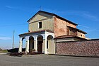
 Church San Lorenzo
 -
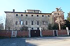 Castle Castello di Galliavola
 -
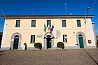 Town hall
 -
 Monumento ai Caduti
 -
 Church Beata Vergine Addolorata allo Zerbaiolo


References
- ^ "Superficie di Comuni Province e Regioni italiane al 9 ottobre 2011". Italian National Institute of Statistics. Retrieved 16 March 2019.
- ^ "Popolazione Residente al 1° Gennaio 2018". Italian National Institute of Statistics. Retrieved 16 March 2019.
- ^ All demographics and other statistics: Italian statistical institute Istat.
- v
- t
- e
- Alagna
- Albonese
- Albuzzano
- Arena Po
- Badia Pavese
- Bagnaria
- Barbianello
- Bascapè
- Bastida Pancarana
- Battuda
- Belgioioso
- Bereguardo
- Borgarello
- Borgo Priolo
- Borgo San Siro
- Borgoratto Mormorolo
- Bornasco
- Bosnasco
- Brallo di Pregola
- Breme
- Bressana Bottarone
- Broni
- Calvignano
- Campospinoso Albaredo
- Candia Lomellina
- Canneto Pavese
- Carbonara al Ticino
- Casanova Lonati
- Casatisma
- Casei Gerola
- Casorate Primo
- Cassolnovo
- Castana
- Casteggio
- Castelletto di Branduzzo
- Castello d'Agogna
- Castelnovetto
- Cava Manara
- Cecima
- Ceranova
- Ceretto Lomellina
- Cergnago
- Certosa di Pavia
- Cervesina
- Chignolo Po
- Cigognola
- Cilavegna
- Codevilla
- Colli Verdi
- Confienza
- Copiano
- Corana
- Cornale e Bastida
- Corteolona e Genzone
- Corvino San Quirico
- Costa de' Nobili
- Cozzo
- Cura Carpignano
- Dorno
- Ferrera Erbognone
- Filighera
- Fortunago
- Frascarolo
- Galliavola
- Gambarana
- Gambolò
- Garlasco
- Gerenzago
- Giussago
- Godiasco
- Golferenzo
- Gravellona Lomellina
- Gropello Cairoli
- Inverno e Monteleone
- Landriano
- Langosco
- Lardirago
- Linarolo
- Lirio
- Lomello
- Lungavilla
- Magherno
- Marcignago
- Marzano
- Mede
- Menconico
- Mezzana Bigli
- Mezzana Rabattone
- Mezzanino
- Miradolo Terme
- Montalto Pavese
- Montebello della Battaglia
- Montecalvo Versiggia
- Montescano
- Montesegale
- Monticelli Pavese
- Montù Beccaria
- Mornico Losana
- Mortara
- Nicorvo
- Olevano di Lomellina
- Oliva Gessi
- Ottobiano
- Palestro
- Pancarana
- Parona
- Pavia
- Pietra de' Giorgi
- Pieve Albignola
- Pieve Porto Morone
- Pieve del Cairo
- Pinarolo Po
- Pizzale
- Ponte Nizza
- Portalbera
- Rea
- Redavalle
- Retorbido
- Rivanazzano Terme
- Robbio
- Robecco Pavese
- Rocca Susella
- Rocca de' Giorgi
- Rognano
- Romagnese
- Roncaro
- Rosasco
- Rovescala
- San Cipriano Po
- San Damiano al Colle
- San Genesio ed Uniti
- San Giorgio di Lomellina
- San Martino Siccomario
- San Zenone al Po
- Sannazzaro de' Burgondi
- Sant'Alessio con Vialone
- Sant'Angelo Lomellina
- Santa Cristina e Bissone
- Santa Giuletta
- Santa Margherita di Staffora
- Santa Maria della Versa
- Sartirana Lomellina
- Scaldasole
- Semiana
- Silvano Pietra
- Siziano
- Sommo
- Spessa
- Stradella
- Suardi
- Torrazza Coste
- Torre Beretti e Castellaro
- Torre d'Arese
- Torre d'Isola
- Torre de' Negri
- Torrevecchia Pia
- Torricella Verzate
- Travacò Siccomario
- Trivolzio
- Tromello
- Trovo
- Val di Nizza
- Valeggio
- Valle Lomellina
- Valle Salimbene
- Varzi
- Velezzo Lomellina
- Vellezzo Bellini
- Verretto
- Verrua Po
- Vidigulfo
- Vigevano
- Villa Biscossi
- Villanova d'Ardenghi
- Villanterio
- Vistarino
- Voghera
- Volpara
- Zavattarello
- Zeccone
- Zeme
- Zenevredo
- Zerbo
- Zerbolò
- Zinasco
| Authority control databases |
|
|---|
 | This article on a location in the Province of Pavia is a stub. You can help Wikipedia by expanding it. |
- v
- t
- e


