Fort Shafter
United States Army Pacific headquarters in Honolulu, Hawaii, USA
21°20′42″N 157°53′02″W / 21.345°N 157.884°W / 21.345; -157.884
commander
commanders
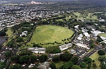
Fort Shafter is a census-designated place[1] located in the City and County of Honolulu, Hawai‘i. It is the headquarters of the United States Army Pacific, which commands most Army forces in the Asia-Pacific region with the exception of Korea. Geographically, Fort Shafter extends up the interfluve (ridgeline) between Kalihi and Moanalua valleys, as well as onto the coastal plain (as Shafter Flats) at Māpunapuna. A portion of the area is also known as the Palm Circle Historic District; it is listed on the National Register of Historic Places and has been further designated as a U.S. National Historic Landmark. It is also known as Palm Circle or 100 Area.
History
Fort Shafter is the oldest military base on Oahu and celebrated its 100th birthday on 22 June 2007.
Fort Shafter has been home to the senior Army headquarters in Hawaii for a century. Construction began in 1905 on the ahupua'a of Kahauiki, former Hawaiian crown lands that were ceded to the United States government after annexation. When the post opened in 1907, it was named for Major General William Rufus Shafter (1835–1906), who led the United States expedition to Cuba in 1898.
Palm Circle was laid out as a cantonment for an infantry battalion. The barracks and officers' quarters were arranged around a parade field ringed by royal palms. The first unit stationed at the new post was the 2d Battalion, 20th Infantry Regiment.
Fort Shafter gradually spread out from Palm Circle. Tripler General Hospital once stood where the highway intersection is today (the hospital moved to its present location in 1948). In 1914, a regimental-sized cantonment area was constructed (near Richardson Theater). The Hawaiian Ordnance Depot was built in 1917 as a separate post (near today's post exchange). In 1921, the Hawaiian Department moved to Fort Shafter from downtown Honolulu. Finally, a new area was constructed in 1940 for Signal Corps elements.
War came to Fort Shafter on 7 December 1941, where the Hawaiian Department commander, Lieutenant General Walter C. Short, occupied Quarters 5. One soldier, Corporal Arthur A. Favreau, 64th Coast Artillery (Anti-Aircraft), was killed on post by an errant Navy shell.[2] Fort Shafter became a busy headquarters and the barracks on Palm Circle were converted to offices. The major headquarters was named successively U.S. Army Forces, Central Pacific Area (1943–44); U.S. Army Forces, Pacific Ocean Areas (1944–45); and U.S. Army Forces, Middle Pacific (1945–47). In 1944, the Army Corps of Engineers erected the "Pineapple Pentagon" (buildings T-100, T-101, and T-102) in just 49 days. Two large fishponds were filled in to form Shafter Flats.
For most of the time since the Second World War, Fort Shafter has remained the senior Army headquarters for the Asia-Pacific region. In 1947, the headquarters was renamed U.S. Army, Pacific. The post continued to adapt to meet the Army's evolving requirements. In the early 1960s it was split in two by the new Moanalua Freeway. In 1974, when the headquarters was eliminated, Fort Shafter became home to U.S. Army Support Command, Hawaii, and the U.S. Army Corps of Engineers, Pacific Ocean Division (relocated from Fort Armstrong, (Hawaii)). In 1979, the Army established U.S. Army Western Command, which was renamed U.S. Army, Pacific in 1990. In 1983, the Army conveyed to the State of Hawaii 750 acres (3.0 km2) of undeveloped land on the northern end of post. Today Fort Shafter remains the focal point for command, control, and support of Army forces in the Asia-Pacific region; it includes an underground command center beneath Palm Circle.
References
- ^ "2010 CENSUS - CENSUS BLOCK MAP (INDEX): Urban Honolulu CDP, HI" (PDF). U.S. Census Bureau. Retrieved 11 October 2020. - Page 4
- ^ Parkman, E. Breck (2019). "A Hypothesis Regarding the Army's Incinerator at Fort McDowell, Marin County, California" (PDF). Articles of the SCA Proceedings. 33: 86. Retrieved 21 January 2020.
 This article incorporates public domain material from History of Fort Shafter, Hawaii. United States Army.
External links
Wikimedia Commons has media related to Fort Shafter.
- US Army Garrison - Hawaii
- United States Army Pacific
- Historic American Buildings Survey (HABS) No. HI-287-C, "Fort Shafter Military Reservation, Facilities No. 820-822, 824, 826-828, 840, 841, 844-846, Rice Street and Herian Place, Honolulu, Honolulu County, HI", 8 photos, 21 data pages, 2 photo caption pages
- HABS No. HI-287-D, "Fort Shafter Military Reservation, Facilities No. 823, 825, 842, Herian Place, Honolulu, Honolulu County, HI", 4 photos, 7 data pages, 2 photo caption pages
- Historic American Landscapes Survey (HALS) No. HI-9, "Fort Shafter Military Reservation, N.C.O. Housing Area, Honolulu, Honolulu County, HI", 9 photos, 27 data pages, 3 photo caption pages
- v
- t
- e
- Ala Moana Beach Park
- Ala Moana Center
- Aliʻiōlani Hale
- Bishop Museum
- Neal S. Blaisdell Center
- Diamond Head
- Federal Detention Center, Honolulu
- Fort Shafter
- Hawaii Convention Center
- Capitol Modern Museum
- Hawaii State Capitol
- Honolulu Hale
- Honolulu Museum of Art
- Honolulu Zoo
- ʻIolani Palace
- Japanese Consulate-General, Honolulu
- Kahala Mall
- Kapiolani Park
- Kewalo Basin
- No. 1 Capitol District Building
- Royal Hawaiian Hotel
- Tripler Army Medical Center
- Waikīkī Aquarium
| Public K–12 | |||||
|---|---|---|---|---|---|
| Private K–12 | |||||
| Tertiary |
| ||||
| Libraries | |||||
- Daniel K. Inouye International Airport
- TheBus
- Skyline
- Honolulu Star-Advertiser
- Honolulu (magazine)
- Cathedral Basilica of Our Lady of Peace
- Cathedral Church of Saint Andrew
- Co-Cathedral of Saint Theresa of the Child Jesus
- Our Lady of the Mount Catholic Church
- Sacred Heart Church-Punahou
- Saint Anthony Catholic Church
- Saint Augustine by the Sea Catholic Church
- Saint John the Baptist Church
- Saint Patrick Catholic Church
- Saints Peter and Paul Catholic Church
| ||||||||||||||||
|---|---|---|---|---|---|---|---|---|---|---|---|---|---|---|---|---|
| Army |
|  | ||||||||||||||
| Marine Corps |
| |||||||||||||||
| Navy |
| |||||||||||||||
| Air Force |
| |||||||||||||||
| Space Force |
| |||||||||||||||
| Coast Guard |
| |||||||||||||||


