Fort McDowell, Arizona
Unincorporated community in the state of Arizona, United States
Unincorporated community in Arizona, United States

Fort McDowell is an unincorporated community in Maricopa County, Arizona, United States. Fort McDowell is 23 miles northeast of Phoenix. Fort McDowell has a post office with ZIP code 85264.[2]
History
The location was named Camp McDowell, and later renamed Fort McDowell in 1867 when established by the California Volunteers on the Verde River in 1865. It was named for Major General Irvin McDowell. The fort was located within Indian country and built to be near the area's travel routes in an effort to protect them from the Apache who lived in the Gila River and Salt River valleys. The post office opened as McDowell in 1869 and changed to Fort McDowell in 1923.[1] Some Native Americans of the region chose to seek refuge in the surrounding mountains rather than conform to the constraints of reservation life. These displaced Indians often traveled in small groups to avoid detection. Their presence, however, caused fear and unrest for nervous settlers, and thus a military outpost (Camp Verde) was deemed necessary to protect trade routes within the region. In addition to the Salt and Verde rivers, Fort McDowell was in close proximity to a number of trails important to the Apache of central Arizona, and the installation conducted numerous military exercises against the Tonto Apache and others. Originally named Camp Verde, the fort was thought to be able to withstand an onslaught from these so-called 'renegades', but in fact, the structures failed to survive the heavy summer monsoon rains, washing away not long after being built. The Stoneman Military Trail served as a supply trail and connected Fort McDowell to Fort Whipple in Prescott, Arizona, during the years 1870–1890.
Climate
According to the Köppen Climate Classification system, Fort McDowell has a semi-arid climate, abbreviated "BSk" on climate maps.[3]
Historic Fort McDowell
Fort McDowell Ruins
-
 The remaining ruins of the Fort McDowell officers quarters located in Ba Hon Nah Road.
 -
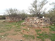 Fort McDowell ruins located in Fort Loop Road.
 -
 The ruins of one of the buildings which belonged to the original Fort McDowell.
 -
 Fort McDowell Church located in Fort Loop Road.
 -
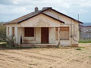 Abandoned house in the land of the Fort McDowell Yavapai Nation.
 -
-
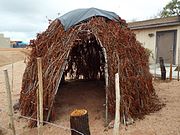
 Yavapai resting area.
 -
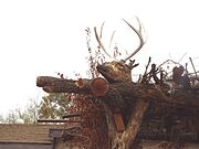 Deer Head on top of the Yavapai resting area.
 -
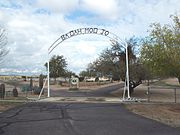 Entrance of the as "Ba Dah Mod Jo" Cemetery also known as the Fort McDowell Yavapai Nation Cemetery.
 -
 The grave of Carlos Montezuma or Wassaja in "Ba Dah Mod Jo" Cemetery. Montezuma was a Yavapai-Apache Native American, activist and a founding member of the Society of American Indians. His birth name Wassaja, means "Signaling" or "Beckoning" in his native tongue. He was the first Native American male to receive a medical degree.
 -
 The grave of Mike Burns, whose real name was Hoo-moo-thy-ah. He was the cousin of Carlos Montezuma. When he was a child he led the US Cavalry to Skeleton Cave where he witnessed the massacre of his people.
 -
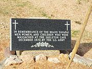 Grave dedicated to the men, women and children who were massacred by the soldiers of the US Army in Skeleton Cave.
 -
 Unidentified graves of the Yavapai who perished during the "Indian Wars”.
 -
 Dr. Carlos Montezuma plaque.
 -
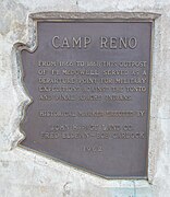 Marker which indicates where the historic Camp Reno was located.
 -
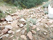 Camp Reno ruins. Camp Reno was a lookout post for Fort McDowell.


References
- ^ a b "Feature Detail Report for: Fort McDowell". Geographic Names Information System. United States Geological Survey, United States Department of the Interior.
- ^ ZIP Code Lookup
- ^ Climate Summary for Fort McDowell, Arizona
External links
- Fort McDowell Yavapai Nation – official site
Municipalities and communities of Maricopa County, Arizona, United States | ||
|---|---|---|
County seat: Phoenix | ||
| Cities |  | |
| Towns | ||
| CDPs | ||
| Populated places |
| |
| Indian reservations | ||
| Ghost towns/ former populated places | ||
| Footnotes | ‡This populated place also has portions in an adjacent county or counties | |
| ||
| Authority control databases |
|
|---|


